
Tropical Cyclone Seth strengthens, with pumping New Year's surf on the way
Tropical Cyclone Seth intensified and was named yesterday afternoon, confirming the prospect of an upcoming large easterly swell event to impact the southeast Queensland and northern NSW coastlines.
The tropical system that eventuated into the second named cyclone over Australian Waters this season had a long journey to its eventual faith. Initially a tropical low to the north of Darwin, it threatened to intensify to cyclonic strength on the Christmas weekend, but remained a low pressure system as it crossed into the Top End. Tracking east, it then crossed into the Gulf of Carpentaria, once again threatening intensification. It rapidly moved across the gulf and into northern parts of Queensland, leading to gusty thunderstorms and heavy rainfall. The tropical low then pushed into the Coral Sea, gradually tracking east and southeast into the warm waters where Tropical Cyclone Seth currently sits.

Image 1: Himawari-8 satellite imagery showing a mass of cloud over the Coral Sea associated with Category 2 Tropical Cyclone Seth on the morning of Saturday 1st.
Seth is currently a category 2 Tropical Cyclone and is about 700km east of Mackay and tracking southeast. It will remain well offshore, and maintain a track parallel to the Queensland coastline over the coming days. Heavy rain and strong winds will generally remain well away from the Australian mainland for the moment, with some more severe weather expected over Lord Howe Island with the system stalling to the north.
So, what will be the impact of Seth on Australia?
Swell. A significant period of heavy surf is expected across much of eastern Australia thanks to this system. While Tropical Cyclones by themselves can lead to relatively underwhelming swell events, a broad high pressure system over the Tasman Sea and New Zealand will cradle the spinning tropical cyclone (see image 2 below). This will enhance a significant area of easterly component winds over these waters, directing large surf to eastern Australia.
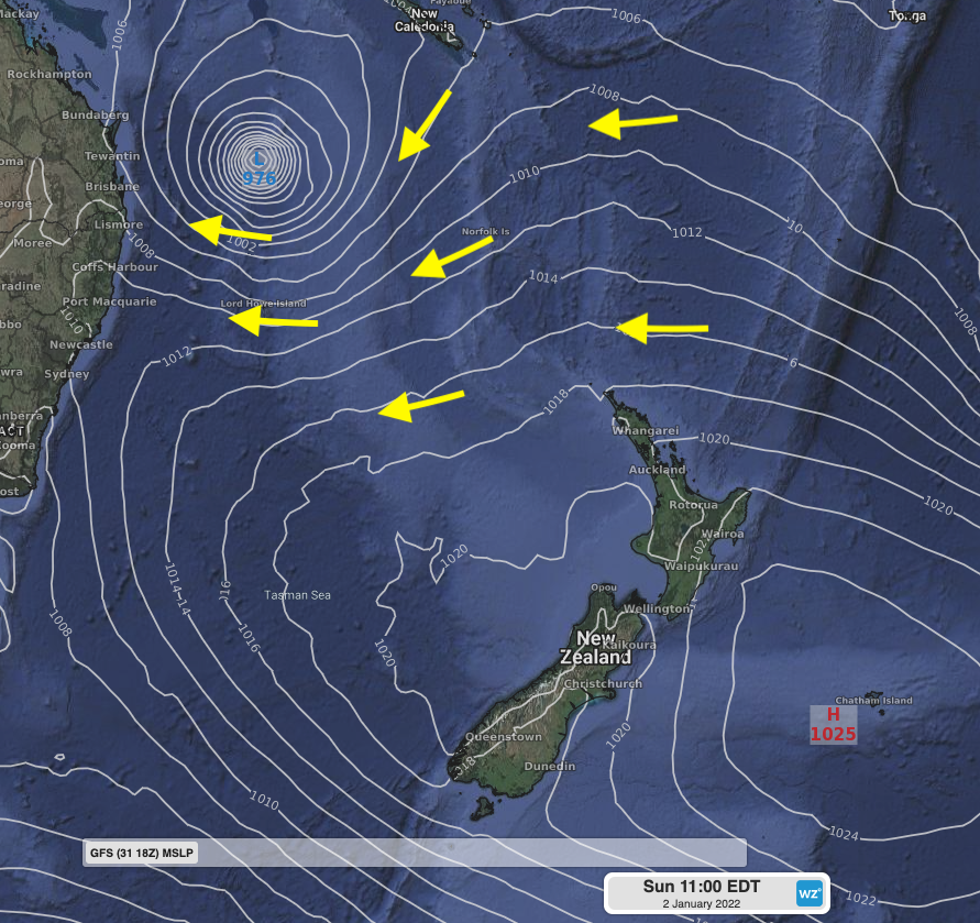
Image 2: MSLP GFS model output for Sunday 2nd morning showing Tropical Cyclone Seth over the lower Coral Sea, with a broad area of high pressure over the Tasman Sea and New Zealand leading to an extensive area of tighter isobars and thus winds directed towards eastern Australia.
Swell height will increase over the course of the weekend reaching into the 3.5-4m range across the Gold Coast and Northern Rivers area late on Sunday. Monday 3rd is the standout day of the week. The swell will ramp up overnight into the 4-5m range, with a significant peak wave period of 12 to 14 seconds, to end the long New Year's weekend. The easterly direction of this swell will mean that large surf will make its way into usually more sheltered bays and points. Combining this swell with a still southerly wind on the western flank of the system, conditions should be optimal for the many points of the region, with heavy surf making this only for experienced board riders – large set waves and lots of water moving about will make for treacherous conditions.
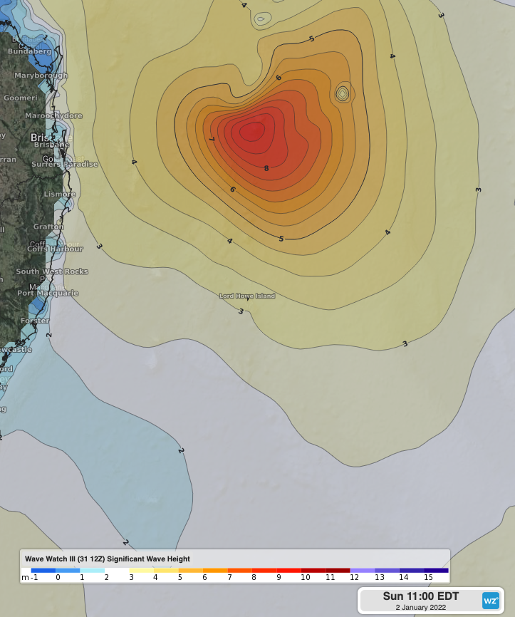
Image 3: Wave Watch III Significant Wave Height on Sunday 2nd morning showing core swell height near 10m, with a broad area of swell in the 3-5m range.
Onwards from Monday, the swell period and height will be set back a notch, but solid surf will be maintained well into the working week. Swell height is expected to remain in the 3-4.5m range until around Thursday, with generally favorable southerly component winds persisting as the low gradually weakens and tracks closer to the coast later in the week.
Hazardous Surf Warnings are currently in place for today and Sunday for the Fraser Island Coast and Sunshine Coast Waters. Sunday also sees these warnings extend south into Gold Coast Waters, and into NSW’s Byron and Coffs coasts. Hazardous Surf Warnings are likely to persist and extending into northern and possible central parts of NSW over the coming days. Severe Weather Warnings are also currently in place over these parts for abnormally high tides and damaging surf. The easterly direction, along with longer period will be particularly impactful in terms of coastal erosion across usually well sheltered bays and beaches. Erosion hotspots such as Byron Bay main beach may see significant beach loss to the ocean over the coming week. Keep tabs on all current warnings here.