
Tropical Cyclone Narelle’s eye is producing lightning – that’s bad news for northern Queensland
Severe Tropical Cyclone Narelle is gaining strength over the Coral Sea as it barrels towards northern Queensland, with clear signs that it could intensify further before making landfall on Thursday night or Friday morning.
At 10 am AEST on Thursday, March 19, Severe Tropical Cyclone Narelle was category 5 system located about 355 km to the northeast of Cooktown. Sustained wind speeds at that time were estimated to be around 205 km/h near Narelle’s core, with gusts reaching about 285 km/h.
Narelle is moving towards the west southwest at about 26 km/h, which is relatively fast for a tropical cyclone. The system is expected to continue on a westward track during the next 24 hours, which should cause it to make landfall over Qld’s Cape York Peninsula on Thursday night or Friday morning.
Lightning near Narelle’s eye
Satellite imagery shows that Severe Tropical Cyclone Narelle has a clear eye, which is characteristic of severe tropical cyclones (category 3 and above on the Australian scale).
Another notable feature of Narelle is prolific lightning near its eye on Wednesday night into Thursday morning.
Lightning near the core of a tropical cyclone is typically an indicator that it is gaining strength. This happens because warm and moisture-laden air rising in the cyclone’s eyewall creates thunderstorms.
Cloud top temperatures near the eye of Severe Tropical Cyclone Narelle were colder than -90°C on Thursday morning, confirming the presence of towering convective clouds that were extending high into atmosphere, producing lightning.
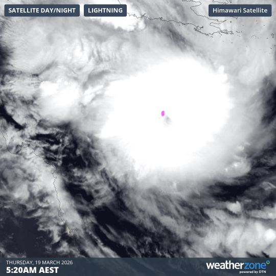
Image: Composite visible satellite images and lightning strike observations, showing lightning near the eye of Severe Tropical Cyclone Narelle on Thursday morning. Source: Weatherzone.
What to expect when Narelle hits Queensland
Current forecasts suggest that Severe Tropical Cyclone Narelle will continue to intensify as it approaches northern Qld on Thursday. At this stage, the system is expected to make landfall somewhere between Lockhart River and Cooktown on Thursday night or Friday morning. Narelle should be a category 4 or 5 tropical cyclone when it crosses the coast.
The impacts from Narelle are likely to include:
- Very destructive wind gusts in excess of 250 km/h near the eye of the tropical cyclone as it makes landfall. Destructive winds with gusts of up to 160 km/h are also likely between about Lockhart River and Cape Flattery, and may extend further south to Cooktown if Narelle takes a more southerly track.
- Heavy rainfall leading to flash flooding is likely between Cape Melville and Cape Tribulation, initially near the coast but also extending across the Cape York Peninsula after landfall. Heavy rain could also extend south along the coast towards Port Douglas, Cairns and Innisfail on Thursday and Friday.
- Abnormally high tides and large waves may cause coastal inundation near and to the south of Narelle’s eye as it approaches and crosses the coast, most likely between Coen and Cape Tribulation. Tides in Princess Charlotte Bay may rise significantly above the normal high tide to cause a dangerous storm tide.
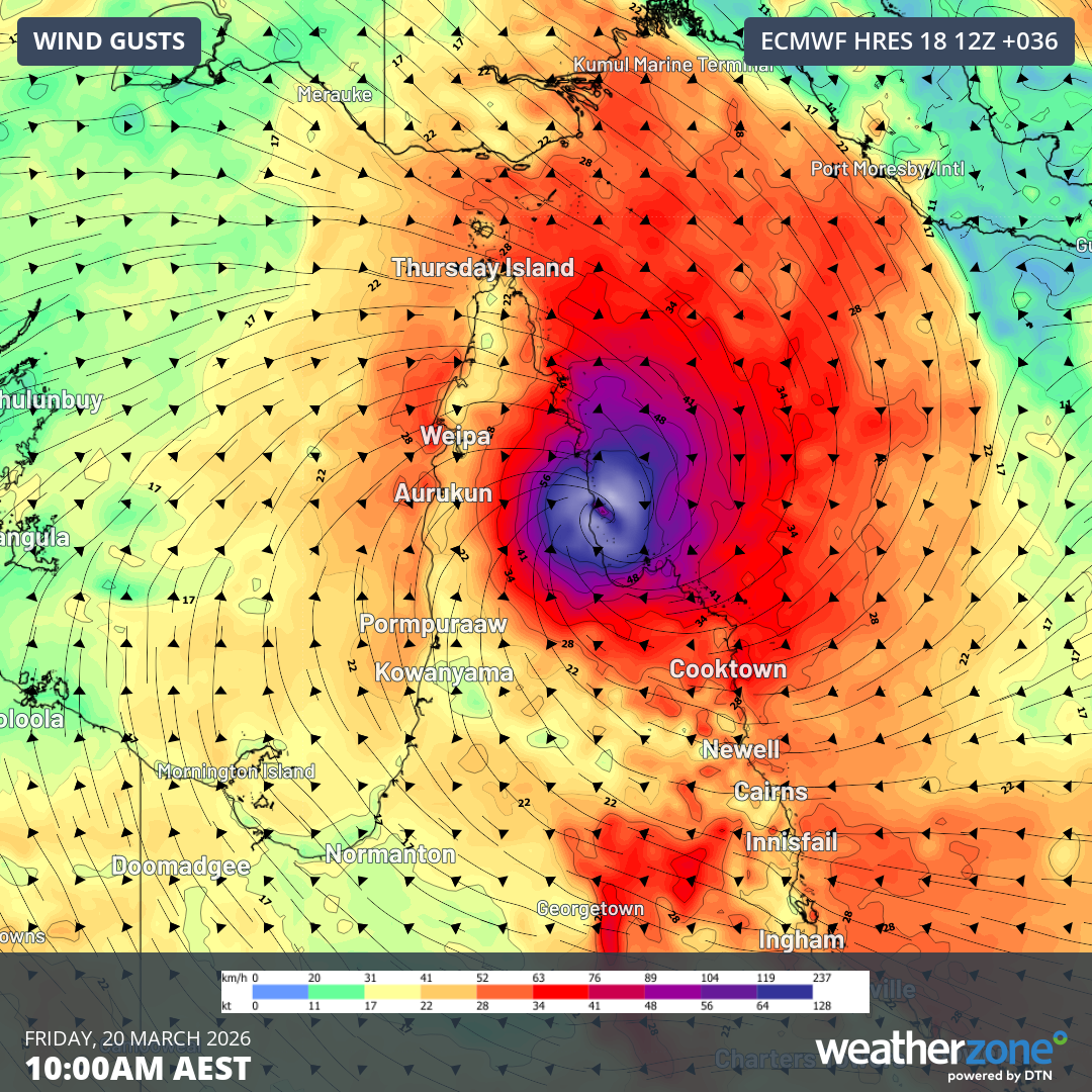
Image: Forecast wind gusts at 10am AEST on Friday, March 20, according to the ECMWF-HRES model. Source: Weatherzone.
Northern Territory next in line
Narelle is likely to weaken after it makes landfall and moves across the Cape York Peninsula on Friday. It will then continue on a westerly track and pass over the Gulf of Carpentaria on Friday night into Saturday.
Computer models suggest that Narelle will re-intensify over warm water in the Gulf before making a second landfall over the Northern Territory’s eastern Top End, possibly over Groote Eylandt, later on Saturday. At this stage, Narelle could be a category 3 severe tropical cyclone when it reaches Groote Eylandt.
Narelle will weaken again after making landfall in the NT, most likely dropping below tropical cyclone strength as it moves across the Top End and Western Australia's Kimberley district on Sunday and Monday. This could cause more heavy rain over flood-ravaged areas of the NT around Daly Waters and Katherine.
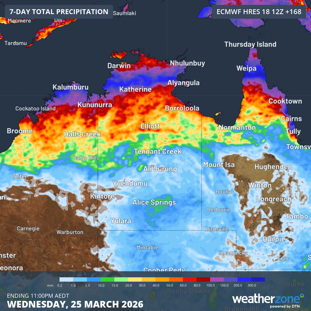
Image: Forecast accumulated rain during the next seven days. Source: Weatherzone.
Looking further ahead, most forecast models suggest that the system will emerge off the Kimberley coast early to mid-next week, where it could re-intensify into a tropical cyclone once again.