
Tropical Cyclone likely to form near WA coast this weekend
A tropical cyclone is expected to develop near Western Australia’s Pilbara coast this weekend, increasing the likelihood of heavy rain, flooding and damaging winds.
At 2am AWST on Friday, a tropical low was located over the western Kimberley district of WA, roughly 50 km northeast of Broome. While this low has been unable to become a tropical cyclone while over land, it has still caused heavy rain over the last few days.
A rain gauge at Curtin received 115 mm of rain during the 18 hours ending at 6am AWST on Friday. Broome also collected more than 50 mm of rain over this period.
Composite radar and satellite images show bands of rain wrapping around the centre of the tropical low as it moved over Broome at sunrise on Friday morning.
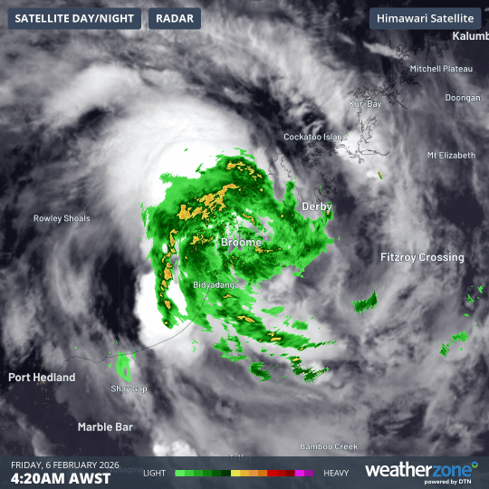
Image: Visible satellite and radar imagery showing cloud and rain associated with a tropical low over the western Kimberley on Friday morning. Source: Weatherzone.
Offshore track increasing tropical cyclone risk this weekend
The low will continue to move towards the west on Friday, allowing the system to move off the west Kimberley coast and start drawing additional energy from warm water to the north of WA. This should allow the system to gain strength as it tracks in a west southwest direction to the north of the Pilbara district over the weekend.
According to the Bureau of Meteorology, the tropical low is likely to become a tropical cyclone late on Saturday and intensify further into Sunday morning while moving towards the west southwest roughly parallel to the Pilbara coast. At this stage, the tropical cyclone is expected to weaken from late Sunday as it turns more towards the south and interacts with the west Pilbara and northern Gascoyne coasts.
Cyclone impacts to include flooding and damaging winds
If this system does become a tropical cyclone and remain close enough to land, parts of the Pilbara could see heavy rain, flooding and damaging winds.
Heavy rain should spread from the Kimberley along the Pilbara coast from Friday night into the weekend, possibly causing flash flooding in some areas. Large waves and abnormally high tides will exacerbate the flood risk in low-lying coastal areas, particularly between about Exmouth and Wickham over the weekend. Wind gusts of up to 120 km/h are also possible along the coast from about De Grey to Onslow on Saturday and early on Sunday.
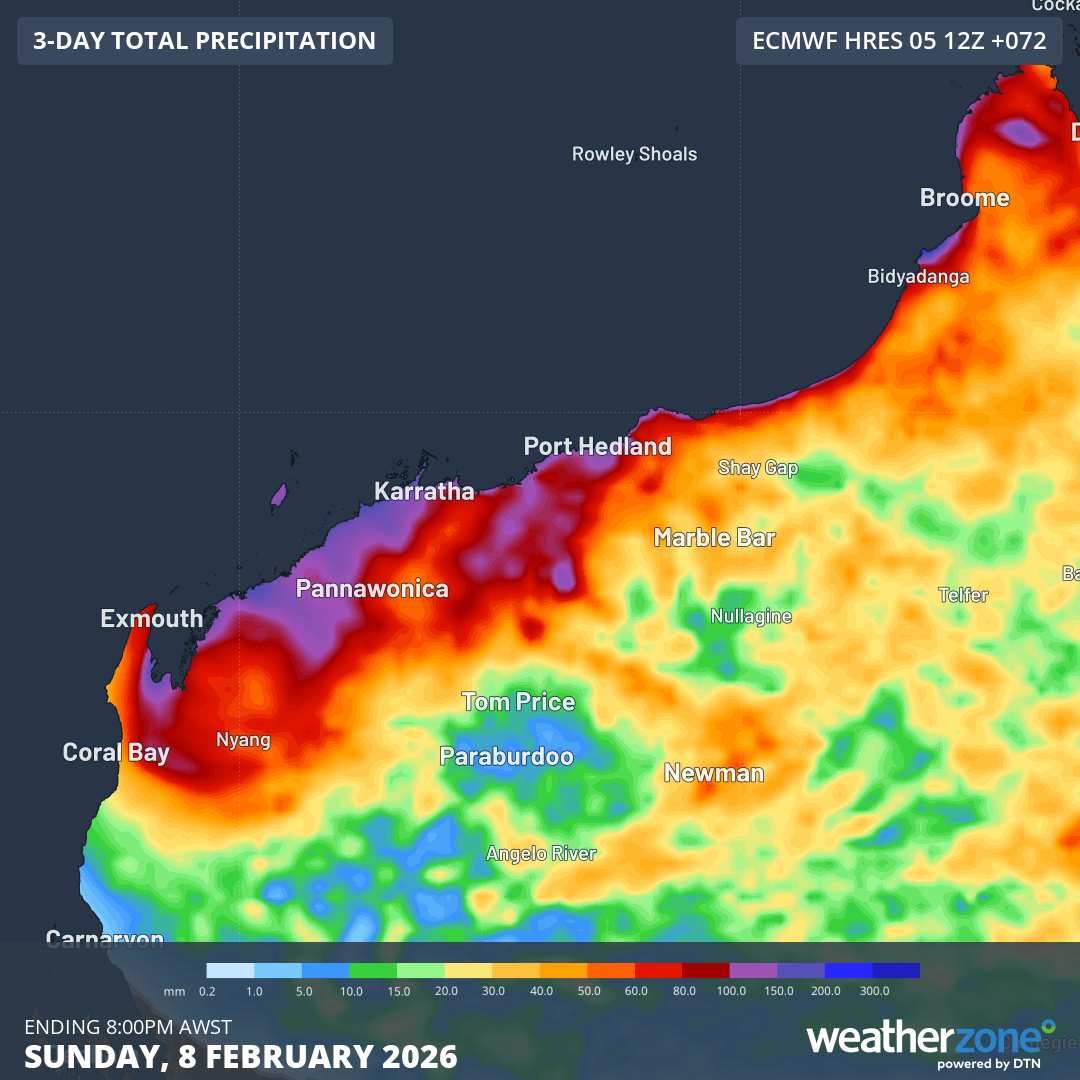
Image: Forecast accumulated rain during the next three days. Source: Weatherzone.
How to prepare for this severe weather event
The hazards associated with this system will depend on how strong it gets and how close it remains to the coast. At this stage, people between the western Kimberley and northern Gascoyne districts, including the Pilbara, should check the latest tropical cyclone advisories, severe weather warnings and flood advisories for the most up-to-date information.
The Department of Fire and Emergency Services (DFES) website has information about what to do before, during and after a tropical cyclone. This includes the following advice for staying safe during a tropical cyclone:
- If sheltering at home, fill sinks, buckets, containers and bath with clean water in case mains water supply is affected.
- When an Emergency Warning has been issued, you must stay inside. It is extremely dangerous to go outside during the cyclone as flying debris can cause injury.
- If you are sheltering at home, look for ways to keep yourself and your family safe. For example, moving to a room without windows, using mattresses and cushions for protection.
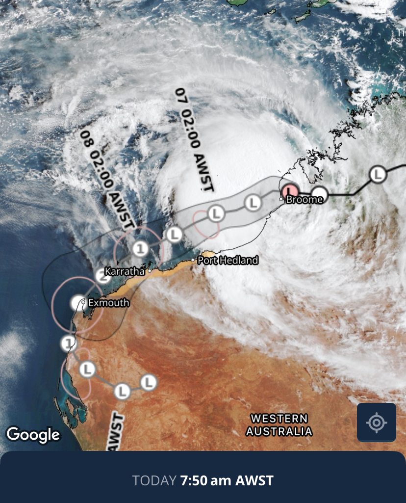
Image: Tropical cyclone forecast track on the Weatherzone app. Source: Weatherzone.
Tropical cyclone to be named Mitchell
There have already been seven tropical cyclones named inside the Australian area of responsibility so far this season, with another one moving into the region after being named near Indonesia.
If the system developing to the north of WA this week is the next tropical cyclone to form in the Australian region, it will be named Mitchell and become the 9th tropical cyclone in Australia’s area of responsibility so far this season. Impressively, this would equal the total number of tropical cyclones from the entire 2023-24 season and exceed the number seen during the 2022-23 season.