
Tropical Cyclone Koji on a collision course with the north Qld coast
Tropical Cyclone Koji (category 1) is approaching the north Queensland coastline on Sunday morning and is forecast to cross the coast between Ayr and Bowen later this morning.
At 4am (AEST) on Sunday, January 11, Koji was a category 1 tropical cyclone, with sustained winds near the centre around 85km/h and peak gusts around 120km/h. The system was located approximately 120km east-northeast of Townsville and 120km north-northwest of Bowen, tracking south at around 18km/h.
Forecast guidance indicates the strongest winds will occur near and south of the centre as Koji approaches the coast, with the Whitsunday Islands particularly exposed to damaging gusts prior to landfall.
Coastal warnings in place
A tropical cyclone warning remains current from Ayr to Mackay, including Bowen, Proserpine and the Whitsunday Islands. The watch zone has been cleared, while the warning for Townsville has been cancelled as Koji continues to track away from the city.
Although Koji is expected to weaken quickly after crossing the coast, its impacts will extend well beyond the immediate coastal zone.
Heavy rainfall and flooding risk
Rainfall is expected to become the dominant hazard as Koji moves inland. Heavy to locally intense rainfall is forecast between Ingham and Proserpine, extending south to Mackay later today.
With river catchments already saturated from recent rainfall, further rain will lead to rapid rises in creeks and rivers, increasing the risk of both flash and riverine flooding across several basins. Flood Watches and Flood Warnings remain current, along with a Severe Weather Warning for parts of the northeast and central Queensland coastline.
Tides are forecast to remain elevated between Cardwell and Mackay, although they are not expected to exceed the highest astronomical tide levels.
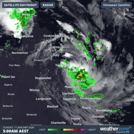
Image: Cloud and rain associated with Tropical Cyuclone Koji on the morning of Sunday, January 11, 2026.
Wind impacts near the coast
Damaging winds with gusts up to 120km/h have already buffeted parts of the Whitsunday Islands. Gusts approaching 100km/h may briefly extend into coastal and nearby inland areas between Ayr and Mackay as Koji nears the coast.
Winds are expected to ease steadily once the cyclone moves inland and weakens during Sunday.
After landfall
After crossing the coast, Koji is forecast to weaken into a tropical low while continuing westward across northern Queensland. Despite losing cyclone strength, the system will remain capable of producing heavy rainfall and localised flooding for the next 24 to 48 hours.
First Coral Sea cyclone in an active Australian season
Koji is the seventh tropical cyclone to form within Australia’s area of responsibility so far in the 2025–26 season, highlighting an unusually active start to the cyclone season.
Earlier systems including Fina, Bakung, Grant, Hayley, Iggy and Jenna, formed over, or moved into, Australia’s western region. Koji now represents the first Coral Sea tropical cyclone this season to directly impact the Queensland coastline.
Staying informed
As Koji crosses the coast, residents are urged to monitor the latest warnings, forecasts and advice from local emergency authorities.
Avoid unnecessary travel during periods of heavy rainfall and never attempt to drive through floodwaters. Secure loose items around your property and follow directions from emergency services to reduce the risk of injury or damage as impacts continue.