
Thunderstorms closing in on southwest WA

A low-pressure system, accompanied by a front and troughs, is currently impacting southwestern parts of Western Australia, bringing rain, wind, and storms.
The low should deepen into this evening and tomorrow, spreading cloud into the southwest and producing some significant weather, before weakening and moving further south and east by Tuesday.
A band of thunderstorms was looming ominously offshore on Sunday morning and made landfall in the late morning. As a result, a severe thunderstorm warning for heavy rainfall has been issued for the South West.
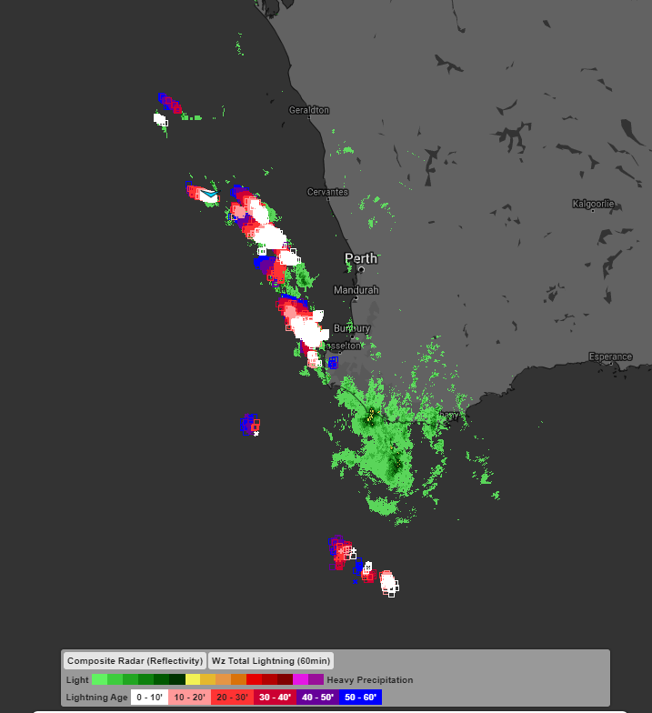
Image: Satellite Image showing lightning and radar for southwest WA on Sunday morning
There should be some significant rainfall totals in the southwest, especially near slow moving thunderstorms, increasing the risk of flash flooding. By the end of today, some of these areas may have received over 30mm of rain, with totals potentially reaching above 50mm by Tuesday. Chapman Hill Road and Vasse have already observed 24mm and 19mm of rain respectively in the hour to 10am this morning.
Winds are less likely to be the main feature of this system but strong gusts are certainly possible near thunderstorms. The strongest winds look likely tomorrow on the capes and exposed coasts of southwestern WA, where gusts above 90km/h are possible.
The system should be clear of the region by Tuesday, although a weak front is expected around Wednesday and Thursday. High pressure building quickly after this front will mean that a few chilly nights could be on the cards for parts of WA.