
Thunderstorms, and an early April soaking on the cards for southeast Australia
Dust off the umbrellas, the rain is on the way for southeastern states early next week!
The Easter weekend is looking picturesque across southeast Australia, but the next big weather system is on its way, bringing some welcome rain to the parched landscapes of Victoria and Tasmania.
As we wrote here earlier this week, a trough developing over the interior is set to move south, linking up with a cold front that will sweep across the region on Easter Monday and Tuesday. The influx of tropical moisture, combining with the cold air coming up behind the front should bring ample instability, providing a good environment for thunderstorms to develop across central and southeast Australia in the coming days.
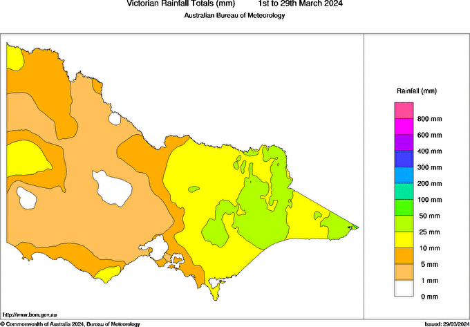
Image: parts of Vic, including Melbourne, will likely record less than 10mm in March 2024. Source: BoM
Through the weekend, thunderstorms will develop across inland parts of SA, the NT, and western NSW. On Easter Monday, the trough will move through southeastern Australia, allowing thunderstorms to develop in the afternoon across Vic, SA, NSW, and possibly even parts of Tas. These thunderstorms could dump as much as 50mm of rain across western and central Vic, including for Melbourne which is on the cusp of their driest March on record. In addition, storms over western and central Vic could bring damaging winds on Monday afternoon.
The heaviest rain should fall over central Vic overnight Monday into Tuesday morning, as a low develops over the Bass Strait, and streaks away to the southeast. The low should also dump heavy rain over Tas as it crosses the state, making it a very soggy Easter Tuesday for our southernmost state.
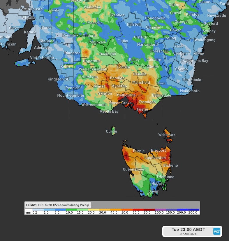
Image: Accumulated rainfall to 11pm EDT Tue 2nd April. It looks like a wet start to the month after a dry February and March across the southeast
Overall, it looks like the end of a prolonged spell with very little rain, that goes back more than 2 months in some areas (Melbourne’s dry March is coming off the back of only 6.2mm recorded in February). Accumulated rainfall totals approaching 100mm are possible across some areas from Sunday until Tuesday night, with showers likely to top up the rain gauges across southern Vic until at least the middle of next week.