
Thunderstorm outbreak to affect every Australian state later this week
Widespread rain and thunderstorms will develop across Australia in the coming days, possibly causing flooding in areas of the country that were baking in 50°C heat just last week.
The water vapour satellite images below highlight copious moisture in the middle and upper atmosphere over northern and central Australia on Thursday. This tropical moisture will interact with a broad area of low pressure over Australia during the next few days, causing wet and stormy weather to extend further south and east across the country.
Image: Enhanced water vapour satellite images captured on Thursday, February 5, 2026. Source: Weatherzone.
Storms in every state and territory
Rain and thunderstorms are possible over part of every Australian state and territory between now and this Sunday and will likely remain widespread across the country throughout next week. This outbreak of storms is likely to feature severe thunderstorms and flooding in multiple states.
The map below shows how much rain one computer model is predicting during the next seven days. Weekly rainfall accumulations could exceed 100 mm in parts of central and northern Australia, with some areas in the north possibly seeing several hundred millimetres.
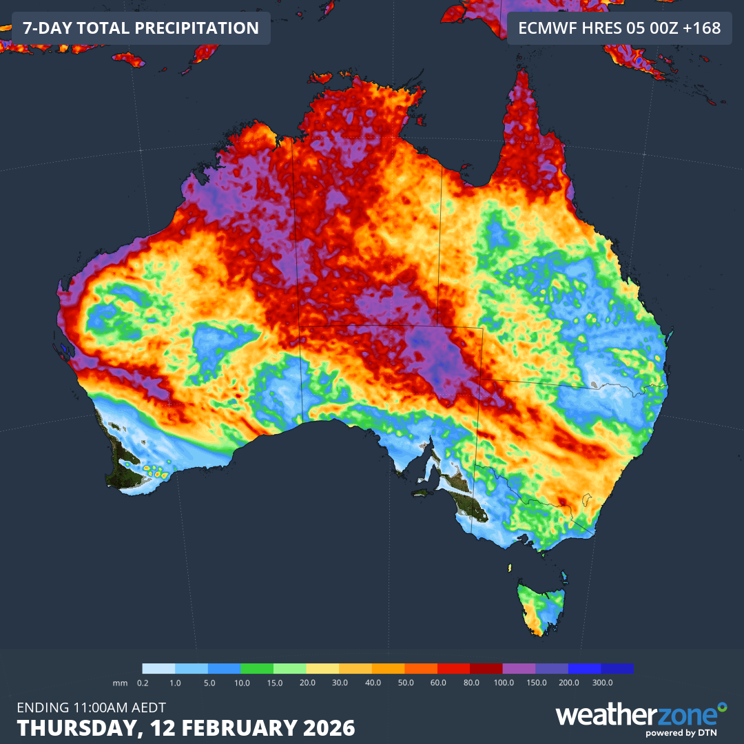
Image: Forecast accumulated rain during the seven days ending on Thursday, February 12, 2026. Source: Weatherzone.
From 50°C to flooding in central Australia
One area that could see several days of heavy rain and storms in the coming week is the north of South Australia and the south of the Northern Territory. Remarkably, it has only been a matter of days since temperatures in this region reached around 50°C.
Marree in SA, which registered a maximum temperature of 49.8°C on Thursday last week, could see 50 to 100 mm by the end of this week. This rain would be enough to cause flooding and may cut off some roads in central Australia. Some of this rain could also be falling straight into Lake Eyre and onto Uluru.
Tropical cyclone potential in Western Australia
Another area likely to see heavy rain and an increased risk of flooding over the coming week is northern WA, where a tropical low pressure system has potential to become a tropical cyclone.
The low, which has already been causing heavy rain over parts of the NT and WA over the last few days, is expected to move off the Kimberley coast on Friday. Once offshore, the system is expected to intensify during the weekend as it tracks towards the west, roughly parallel to WA’s north coast. The Bureau of Meteorology currently gives this system a high chance of becoming a tropical cyclone off the Pilbara coast on the weekend.
This developing low pressure system is likely to cause areas of heavy rain over northern WA in the coming days, although where and how much rain falls will depend on the systems track and strength during the weekend and early next week.
Anyone living in northern WA should keep a close eye on the latest tropical cyclone advisories and weather warnings from this weekend into next week.