
Thousands without electricity as storms smash SA today. Storms to hammer eastern AUS tomorrow.
Widespread severe thunderstorms are smashing SA and damaging the power network with lightning strikes and damaging winds within storms. So far (to around 3pm AEDT), this has disrupted the electricity of around 16,000 residents during the day. Severe storms are ongoing and continue to pose danger to life and property.
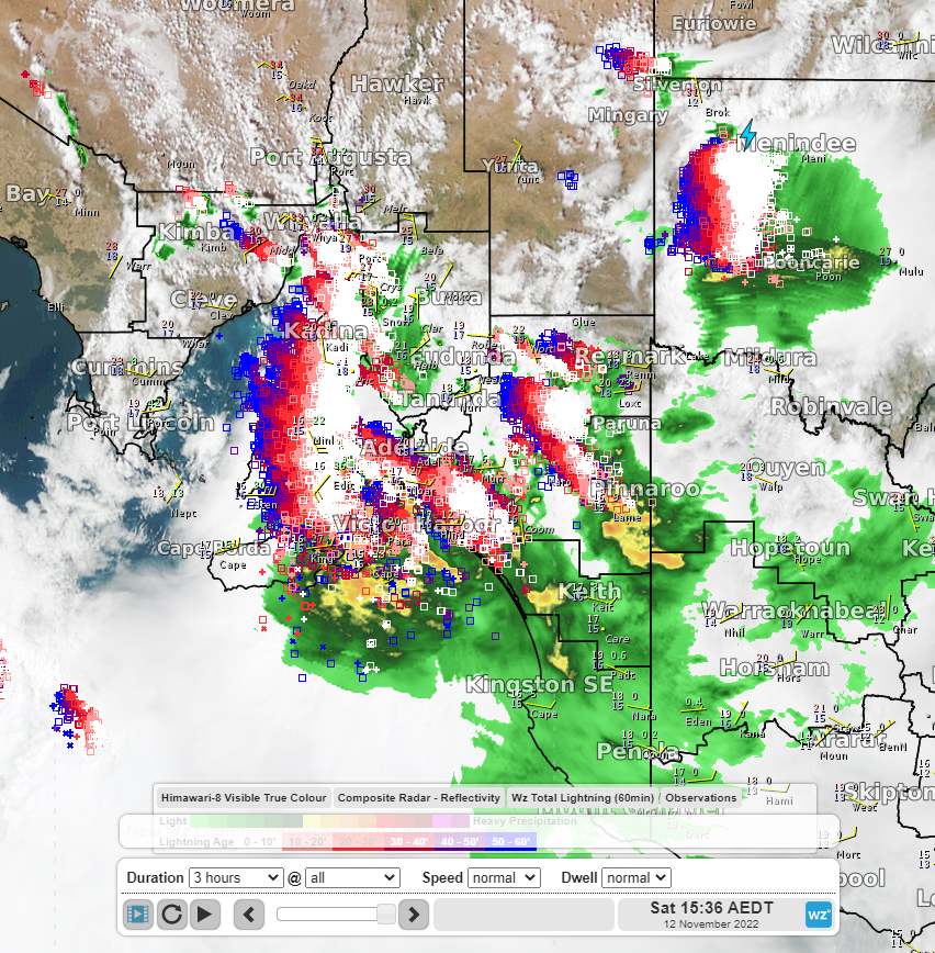
Image: Visible Satellite imagery, radar and lightning strikes at 15:36pm AEDT
The Bureau of Meteorology have issued severe thunderstorm warnings for parts of SA including the Adelaide region for thunderstorms capable of producing damaging winds, large hail and heavy rainfall leading to flash flooding. There was a heavy downpour at Port Lincoln which recorded 35mm in the 2 hours to midday. So far today, there has been over 125,000 lightning strikes within 300km of Adelaide. There is also a warning for severe thunderstorms for parts of NSW today.
Storms are developing in an unstable atmosphere with abundant water vapour and low pressure, and they are becoming severe with support from the strong winds of the Jetstream. The following satellite imagery shows the large amounts of water vapour over southeast AUS in dark blue shading and the dry air in brown shading to the west. The boundaries between the moist air and dry air reveals a wave pattern of the Jetstream which is helping the air to rise and produce rain and storms.
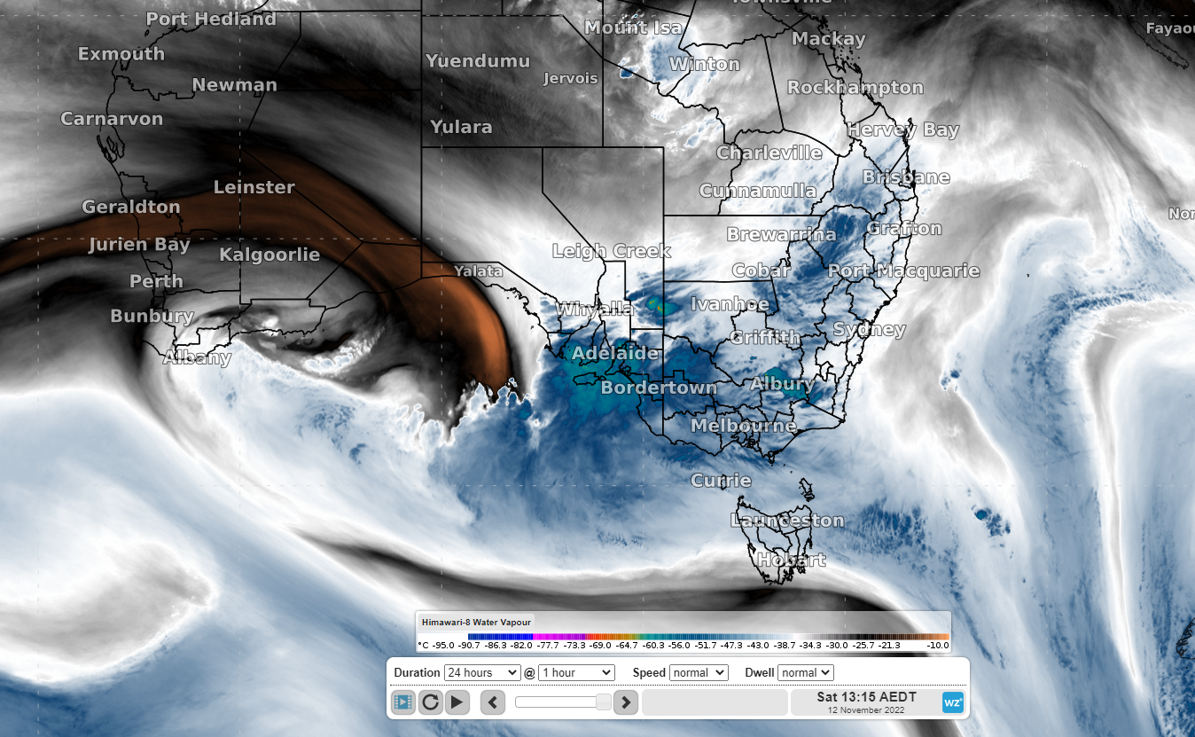
Image: Water Vapour Satellite Imagery at 1:15pm AEDT
As the system moves eastward into tomorrow, heavy rain will develop over VIC and NSW and severe thunderstorms will hammer parts of NSW, QLD, the ACT, VIC, northeast SA, and the NT, possibly including Melbourne, Canberra, and Sydney. The Bureau of Meteorology have issued severe weather warnings for heavy rainfall for tomorrow and will monitor for the development of severe thunderstorms during tomorrow. Some storms will be capable of producing large hail and possibly giant hail, damaging, and destructive wind gusts and heavy rainfall leading to flash flooding.
The following map shows the Severe Weather Threat Index for tomorrow afternoon (5pm AEDT) showing a large area of potential for severe thunderstorms in the orange shading.
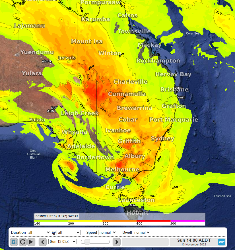
Image: Severe Weather Threat Index (ECMWF model) for Sunday 2pm AEDT 13th November
It is important to follow the advice of emergency services and stay up to date with the latest weather warnings and thunderstorm warning at: