
There's a strong polar vortex over Antarctica - here's what that means for Australia
The air high above Antarctica is currently at record cold levels for this time of year, and this could affect the weather in Australia this summer.
-- Weather under pressure --
The day-to-day weather that we experience in Australia comes from interactions between areas of high and low pressure near Earth's surface.
Put simply, air flows from areas of high pressure towards regions of low pressure. As air converges on these low pressure systems, this is where we typically see clouds and rain.
Of course, there is more to it than that, but the position and strength of high and low pressure systems near Australia play a big role in determining our daily weather.
-- Climate drivers influence weather --
Broad-scale climate drivers – such as La Niña, El Niño, the Indian Ocean Dipole (IOD) and the Southern Annular Mode (SAM) – can all change the way these weather-producing high and low pressure systems interact near Australia.
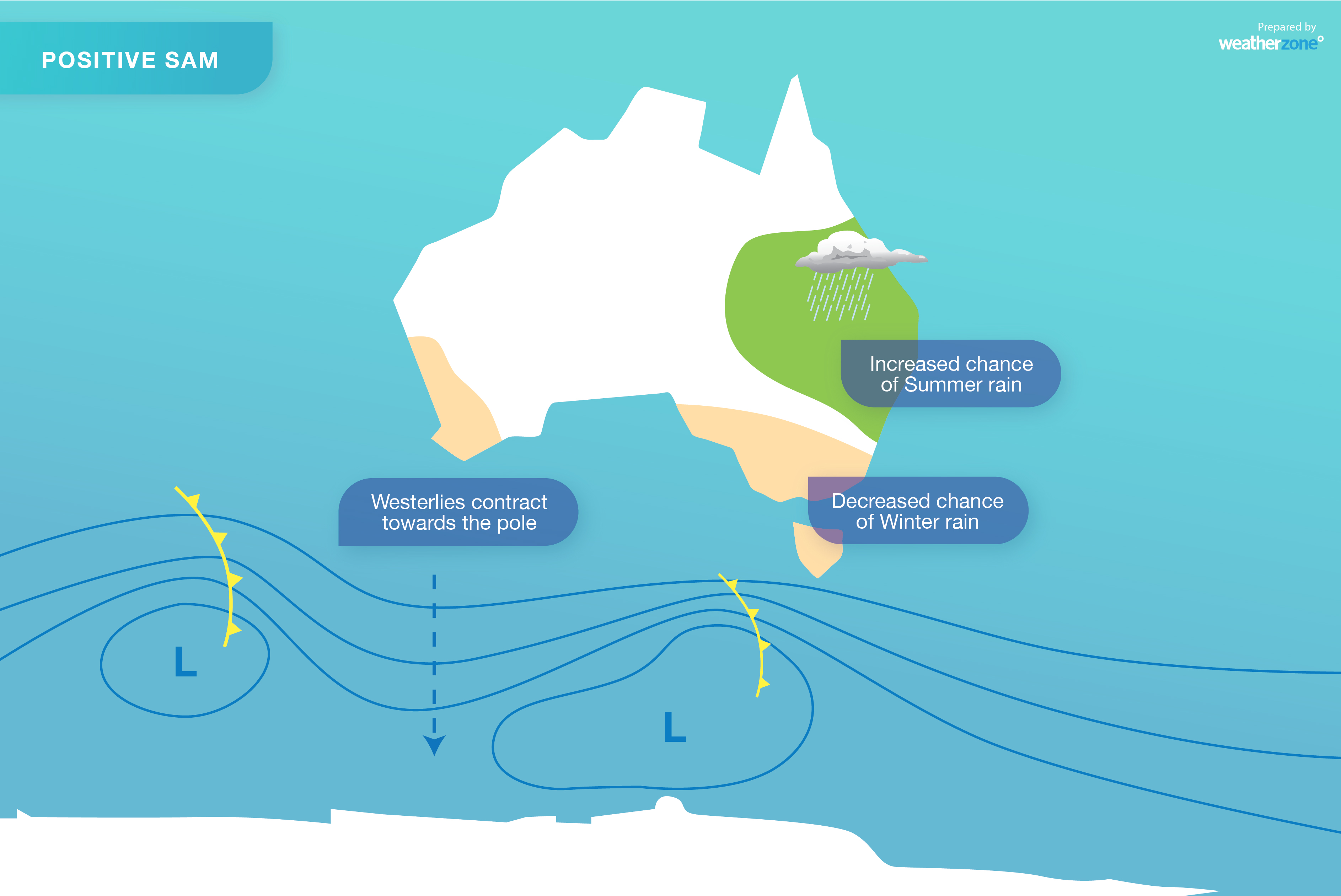
For example, the SAM is an index that measures the north-south displacement of the rain-bearing westerly winds that flow between Australia and Antarctica. During a positive phase of the SAM, these westerlies shift further south.
In winter, this southward displacement causes abnormally high pressure over southern Australia, which can reduce winter-time rainfall over some of our southern states. But if a positive SAM happens in late spring or summer, we can see an increase in onshore winds along the east coast, leading to more rainfall and less extreme heat over large areas of eastern and southeastern Australia.
Similarly, La Niña events typically cause higher-than-normal sea level pressure to the south of Australia and east of New Zealand, and lower air pressure over Australia and the Coral Sea, in summer. These anomalies promote the flow of moisture-laden air over Australia from the east, which can enhance rainfall and reduce temperatures in eastern Australia.
-- Current state of play --
With the connection between broad-scale climate drivers and local weather patterns in mind, it's worth noting that something unusual is happening high above Antarctica at the moment. Something that could affect Australia's weather as we head into summer.
Each winter, months of darkness over the south pole cause a large mass of very cold air to develop about 30-50 kilometres above Antarctica. This cold air is surrounded by a strong ring of westerly winds, which form something called the southern hemisphere's 'stratospheric polar vortex', more commonly referred to as just the 'polar vortex'.
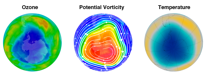
Image: An example of the polar vortex in August 2011, depicted using ozone (left) potential vorticity (centre) and potential temperture at 50 hPa (right). Source: NASA
In a typical year, the polar vortex peaks in winter and breaks down in spring as sunlight returns to the south pole and the air in the stratosphere warms up. However this year, the vortex has persisted well into November at an unprecedented strength.
Dr. Amy Butler, an Atmospheric Scientist at the NOAA's Earth System Research Laboratory, tweeted that polar vortex temperatures have never been recorded this low, this late in spring.
Never before seen minimum temperatures in the Southern Hemisphere #polarvortex... with temperatures cold enough for PSC Type II formation a full month longer than average. pic.twitter.com/5UXkuypXc8
— Amy H Butler (@DrAHButler) November 11, 2020
-- What this means for Australia --
There is a well-documented link between the stratospheric polar vortex and weather patterns closer to the ground in the southern hemisphere.
Over the last fortnight, the abnormally cold air over Antarctica has produced a strong positive phase of the SAM.
Remember that during late spring and early summer, a positive SAM typically causes above-average rain and below average temperature over eastern and southeastern Australia.
Unsurprisingly, maximum temperatures have been below average over a broad swathe of southeastern Australia during the last couple of weeks. There was a particularly cool spell last Thursday, which produced Sydney's coldest November day in 26 years. While rain hasn't been exceptional everywhere, some places in eastern NSW have already exceeded their average November rain, only one third of the way through the month.
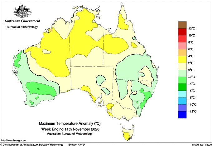
Image: Observed maximum temperature anomalies during the week ending on November 11. Source: Bureau of Meteorology
If the unusually strong polar vortex continues to influence the SAM as we head into summer, which is possible, it would increase the likelihood of above average rain and fewer heat extremes over eastern and southeastern Australia. The likelihood of this occurring is also compounded by the current La Niña conditions.
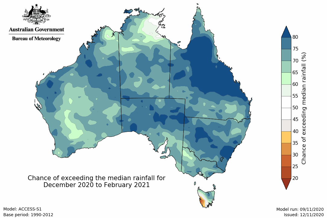
Image: Summer rainfall outlook for Australia. Source: Bureau of Meteorology
The state of climate drivers heading into this summer are a stark contrast to last year. In 2019, an unusually weak polar vortex and associated negative SAM helped send large areas of eastern Australia deeper into drought. This dry and hot end to the year also caused a devastating bushfire season in eastern and southeastern Australia.
This summer, a strong vortex and positive SAM, in addition to La Niña, could help suppress the fire season and cause an increase in drought-relieving rain.