
The return of the polar vortex
Every autumn the Stratospheric Polar Vortex redevelops around the North Pole and every winter, its behavior can influence weather patterns across the United States and other parts of the northern hemisphere.
Development of the Stratospheric Polar Vortex
During the boreal autumn, temperatures towards the north pole start to decrease, with a more rapid cooling than in the mid-latitudes and towards the tropics. As a result, the ‘temperature gradient’ from north to south steepens, and this sets up a broad low pressure area and anti-clockwise flow of winds around the polar region. This is the Stratospheric Polar Vortex (SPV).
When it develops normally, the SPV is more-or-less circular and even. It extends from the stratosphere to the lower parts of the atmosphere, but the topography of the surface causes more erratic and wavy flows closer to the surface, typified by the course of the polar jet stream. However, when the SPV is especially strong, the jet stream can be stronger and smoother with fewer kinks.
A weaker or disrupted SPV can – as long as its effects translate downwards – cause the the polar jet stream to weaken and buckle, with more exaggerated northward and southward loops. These disruptions can start with a surge of warmer air towards the pole, causing a Sudden Stratospheric Warming (SSW) event.
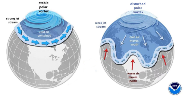
Image: Comparison between and stable (left) and disrupted (right) polar vortex structure. Source: NOAA
Within those southward ‘lobes’, parts of the northern hemisphere can see cold and snowy Arctic outbreaks. So, it’s important to monitor the state of the SPV as we venture towards winter, and even to try to predict its likely state.
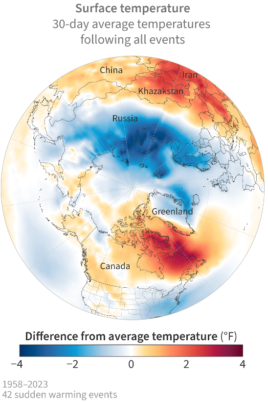
Image: Average changes in surface temperature for the 30 days after 42 observed major sudden stratospheric warmings from 1958-2023. Source: NOAA / Climate.gov
Current state of the SPV
The first signs of Arctic cooling came in August, and a rapid transition is going to set in through September and October. The stratosphere normally reaches its coolest stage later November and during December, when the SPV is usually at its strongest.
This year, as graph below shows, the stratospheric circumpolar winds have steadily risen, with westerly winds (positive phase) up to about 10 m/s by mid-September. There are a couple of things to notice: firstly, the black line, showing the climate mean, showing the usual strengthening through autumn and weakening during spring as the pole starts to warm and the SPV weakens; secondly, the plummeting wind in March last year (blue line) when we had a SSW event and disrupted SPV.
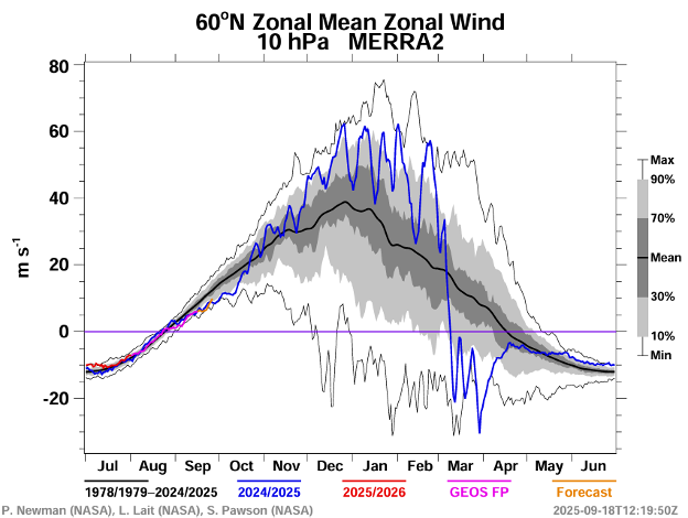
Image: Zonal mean wind (average east-west wind component) at the 10 hPa pressure level at 60 degrees North latitude. Source: NASA Ozone Watch
As well as the temperature, the pressure is starting to fall over the pole, and the more it does so the stronger the circumpolar winds will become, meaning a strengthening vortex, locking the coldest air up in the Arctic.
What might happen this winter?
Although a steady strengthening of the polar vortex will continue through the next couple of months, there are outside influences that are likely to have an impact during the winter.
Firstly, a weak La Niña is developing as the waters of the equatorial Pacific cool, and this, via global teleconnections, can cause some weakening of the SPV.
Secondly, there is a phenomenon called the Quasi-Biennial Oscillation (QBO), which measures lower stratospheric winds at the equator. It flips between westerly and easterly phases approximately every 28 months, so it’s relatively predictable. This winter it’s going to be in a strong easterly phase, which often has more of a disruptive effect on the polar vortex.
In addition, Arctic sea-ice is at very low levels, especially in the Barents Sea and Kara Sea, and this can allow more transport of warmer air northwards, also leading to disruption.
As ever, though, the exact nature of any Polar Vortex disruption will dictate which part of the northern hemisphere ends up most susceptible to Arctic outbreaks.