
The EPO, MJO, SPV and Arctic Outbreaks
There are many large-scale patterns in the atmosphere and oceans that connect weather phenomena around the world. These are called teleconnections, and early recognition of changes in these patterns can help meteorologists spot possible weather outcomes at longer ranges.
La Niña
This winter, for example, the expectation of La Niña gave us an early heads-up on the likely overall recurring background shape of circulations across North America through the season as a whole.
La Niña’s typical pattern places a high pressure ridge across Alaska or the Gulf of Alaska, with a commensurate trough downstream across the North-Central Plains and the Great Lakes or Ohio Valley areas. This leads to chances of cold Arctic outbreaks across the North-Central US / Midwest, warmer and drier conditions overall in the Southeast and Southern Tier, and above-average rainfall and snow for the West Coast, especially from the Pacific Northwest to northern California.
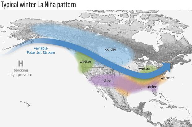
Image: Idealized La Niña patterns in winter. Source: climate.gov
Sub-seasonal climate drivers
However, there are always variations within this at the sub-seasonal range (around 2-4 weeks). For example, during wintertime you will often hear talk of the Stratospheric Polar Vortex getting disrupted, weakened and displaced or split. Its effects do not always propagate downwards into the troposphere, but when they do the result can be ‘blocked’ weather patterns, with high pressure building at high latitudes. Large scale atmospheric planetary waves (known as ‘Rossby waves’) become more amplified and sluggish, and the jet stream takes more extravagant loops northward and southward.
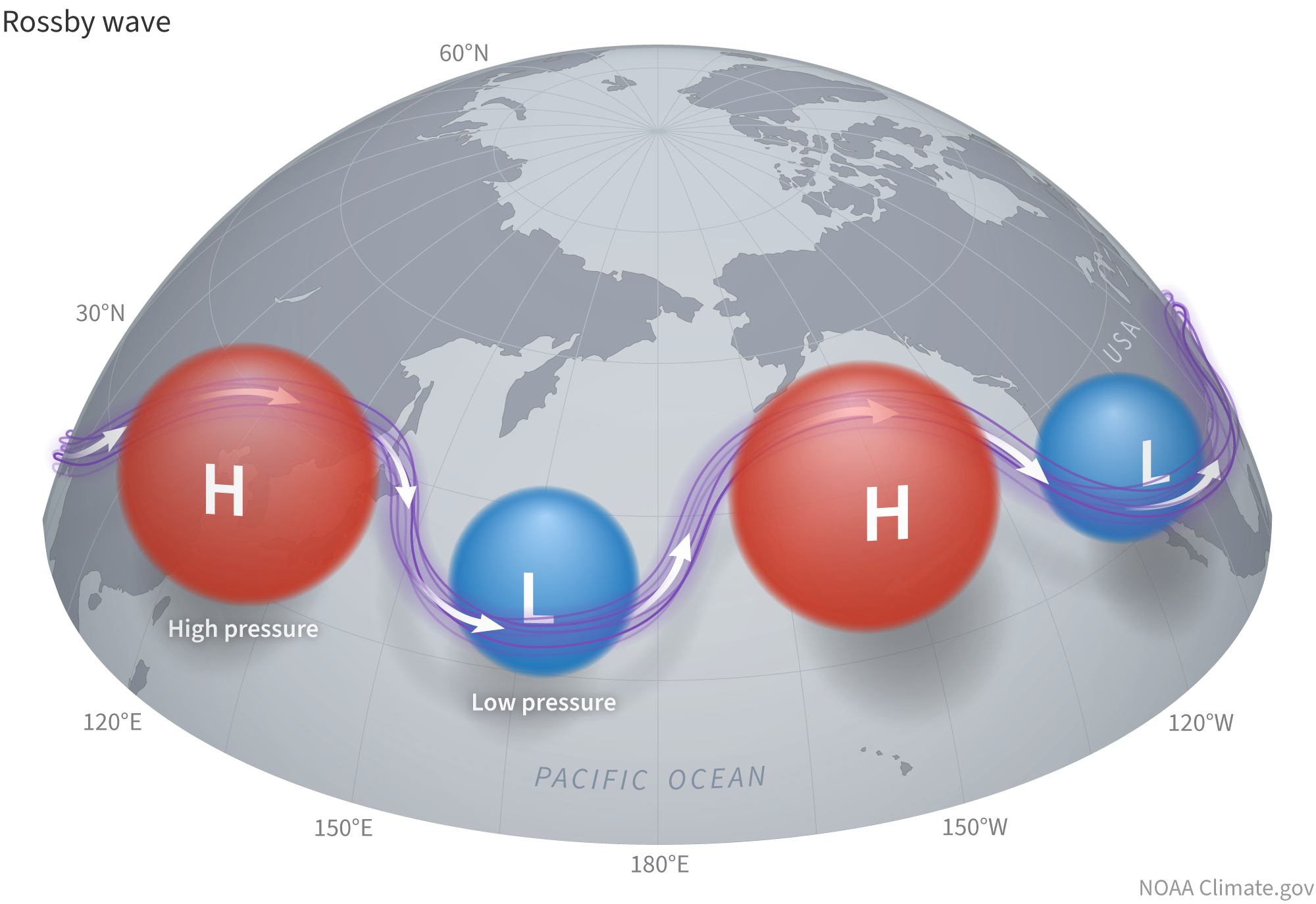
Image: Idealized Rossby waves. Source: climate.gov
This results in warmer-than-usual air pushing north towards the crests of these waves while cold air plunges southwards into the troughs. For an example, we only have to look back to late November and December 2025, when the SPV was strongly disrupted during a sudden stratospheric warming event. The SPV was weakened and displaced again by mid-January.
The EPO
Stratospheric disruptions can impact one of the most important winter teleconnections, which is the East Pacific Oscillation (or EPO). This is a pattern that describes changes in pressure across the northeastern Pacific and Alaska. As it did last December, and is occurring again in January, a disturbed or split SPV can result in blocked circulations that include anomalously high pressure over Alaska and the Gulf of Alaska, which induces troughing downstream and allows Arctic air to pour across Canada and into large parts of the US.
This pressure rise near Alaksa is the negative phase of the EPO, which reinforces the broad underlying seasonal La Niña pattern. If it can be recognized well in advance, then chances are reasonably good that it will give a long-range heads-up on the possibility of a cold outbreak. Negative EPO patterns tend to direct the coldest air tp areas between the Rockies and the Great Lakes.
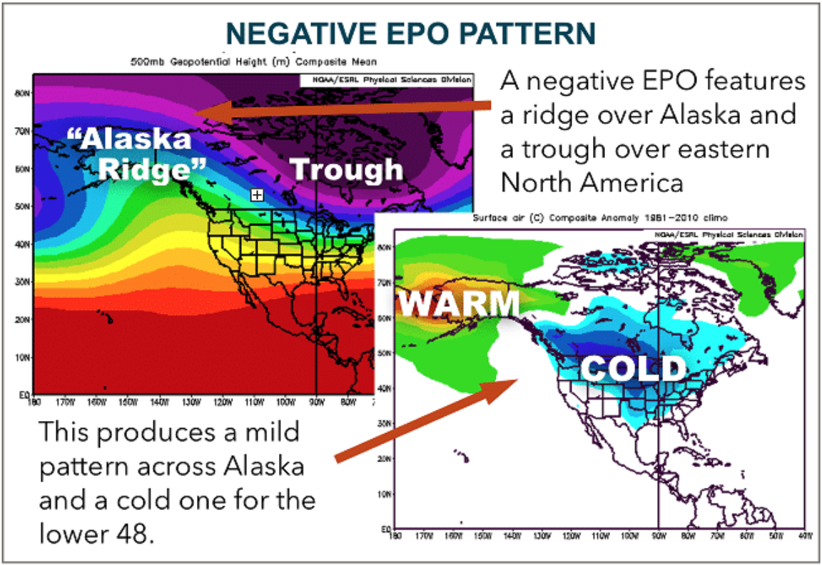
Image: Negative EPO pattern. Source: DTN.
Another Arctic Outbreak
A positive phase of the EPO developed earlier in January, with a low pressure anomaly across Alaska and extending southwards near the West Coast. This promoted a strong ridge across the eastern US, and allowed mild or even warm Pacific-sourced air to wash across, with some near-record temperatures for parts of the East and Central US. However, we have already flipped back to a negative EPO regime, which will strengthen, resulting in deep troughing downstream and a major Arctic outbreak through the rest of January.
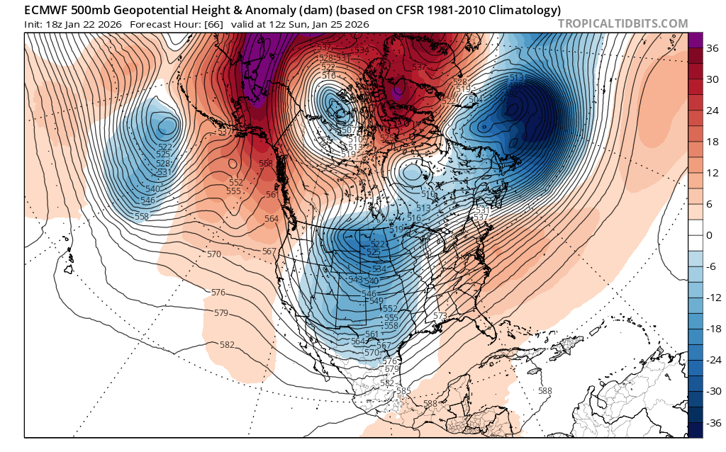
Image: ECMWF model – 500hPa geopotential height anomaly forecast for 12:00 UTC, Sunday January 25th, showing strong high pressure over Alaska and consequent downstream troughing through the Central US. Source: tropicaltidbits.com
A period of heavy snow will occur from Oklahoma through the southern Ohio Valley to the northern Mid-Atlantic and southern New England as this starts to set in. Meanwhile, a major ice storm will threaten parts of the Arklatex region, the Tennessee Valley and the Carolinas, making travel difficult or impossible and potentially knocking out power for days.
The MJO
More support for this development came from the Madden-Julian Oscillation (MJO). This is a cluster of equatorial convection that traverses the globe, the impacts of which can extend far beyond the tropics. It has been strengthening while making slow eastward progress across the West Pacific. Analogues and past experience show that this has a tendency to force the strong development of high pressure in and around Alaska.
So, there were several strands of evidence that pointed towards the likelihood of this Arctic surge 2-3 weeks ahead, giving relevant authorities and companies at least a heads-up to prepare. Details on the exact depth and extent of the cold have been refined daily as the event has drawn closer.