
Tasman Sea 'warm blob' to fuel heavy rain in NSW, Vic this week
A complex low pressure system interacting with a pool of abnormally warm Tasman Sea water is about to cause heavy rain and thunderstorms in southeast NSW and eastern Vic, with flooding likely in some areas from Wednesday.
A tongue of exceptionally warm water has moved down the NSW coast over the past month, driven by the East Australia Current and an associated large eddy in the Tasman Sea.
According to satellite data, sea surface temperatures off the east coast of Tasmania, Vic and southern NSW are currently sitting in the highest 10 percent of historical records for this time of year.
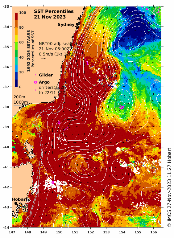
Image: Sea surface temperature percentiles on November 21, 2023. The darkest red shading shows areas where temperatures are in the highest 10 percent of historical records relative to 1992-2016. Source: IMOS
This injection of warmth has produced a pool of water to the east of Bass Strait where sea surface temperatures are a whopping 6ºC warmer than usual for this time of year, according to data collected by an Argo Float last week. This abnormal warmth also extends more than one kilometre below the surface.
This pool of unusually warm water is about to play a role in producing heavy rain and thunderstorms in southeastern Australia over the next few days.
A broad low pressure system located over the southern inland of NSW on Tuesday morning will drift towards the southeast over the coming days. This low is going to produce widespread rain and thunderstorms over NSW, Vic and the ACT.
A second low pressure centre is expected to develop somewhere off the southern coastline of NSW by Wednesday morning, causing a stream of moisture-laden winds to flow over southeast NSW and eastern Vic. This onshore flow will be drawing moisture from the ‘warm blob’ to the east of Bass Strait, which is likely to enhance rainfall.
Rain should increase on Tuesday night into Wednesday morning as the low develops and showers will persist into Thursday for some areas. Six-hour rain rates could reach 50 to 150mm on Wednesday morning and accumulated totals may exceed 200 mm by the end of Thursday.
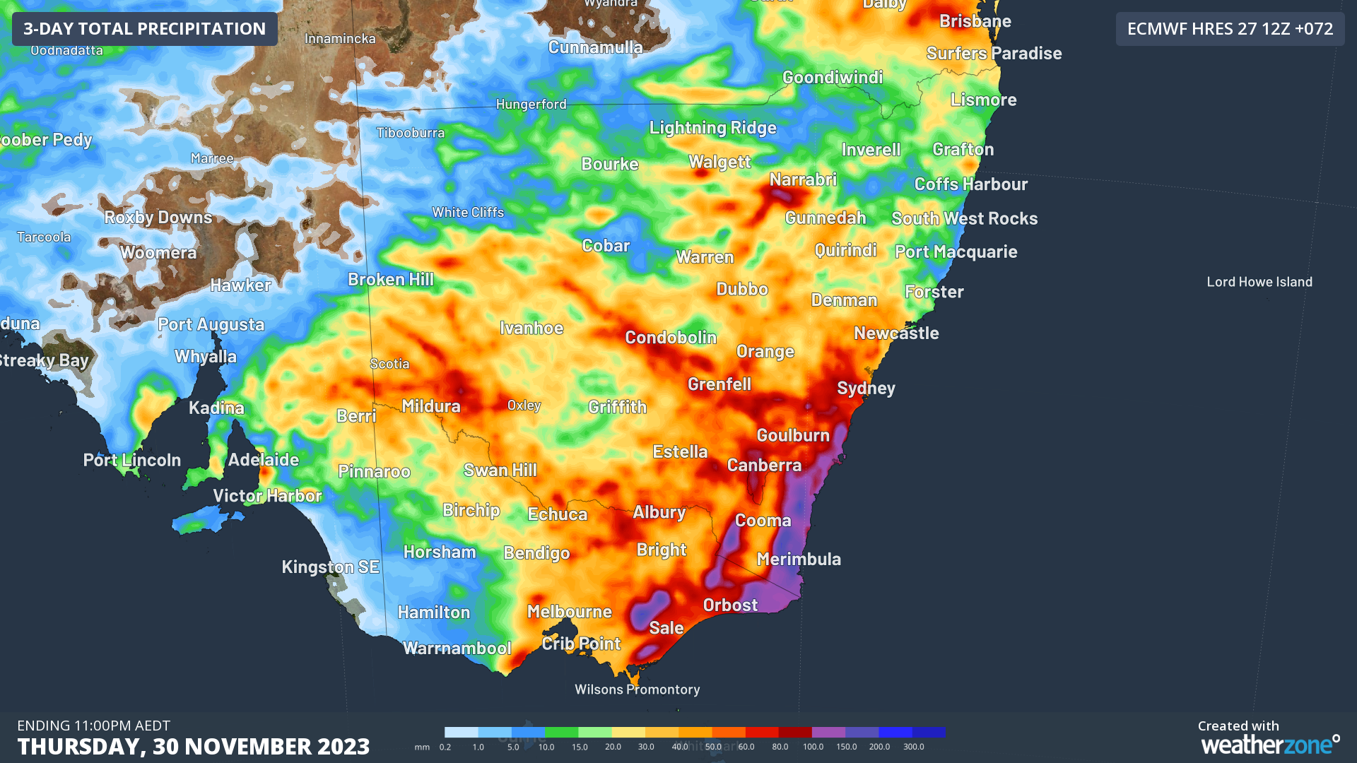
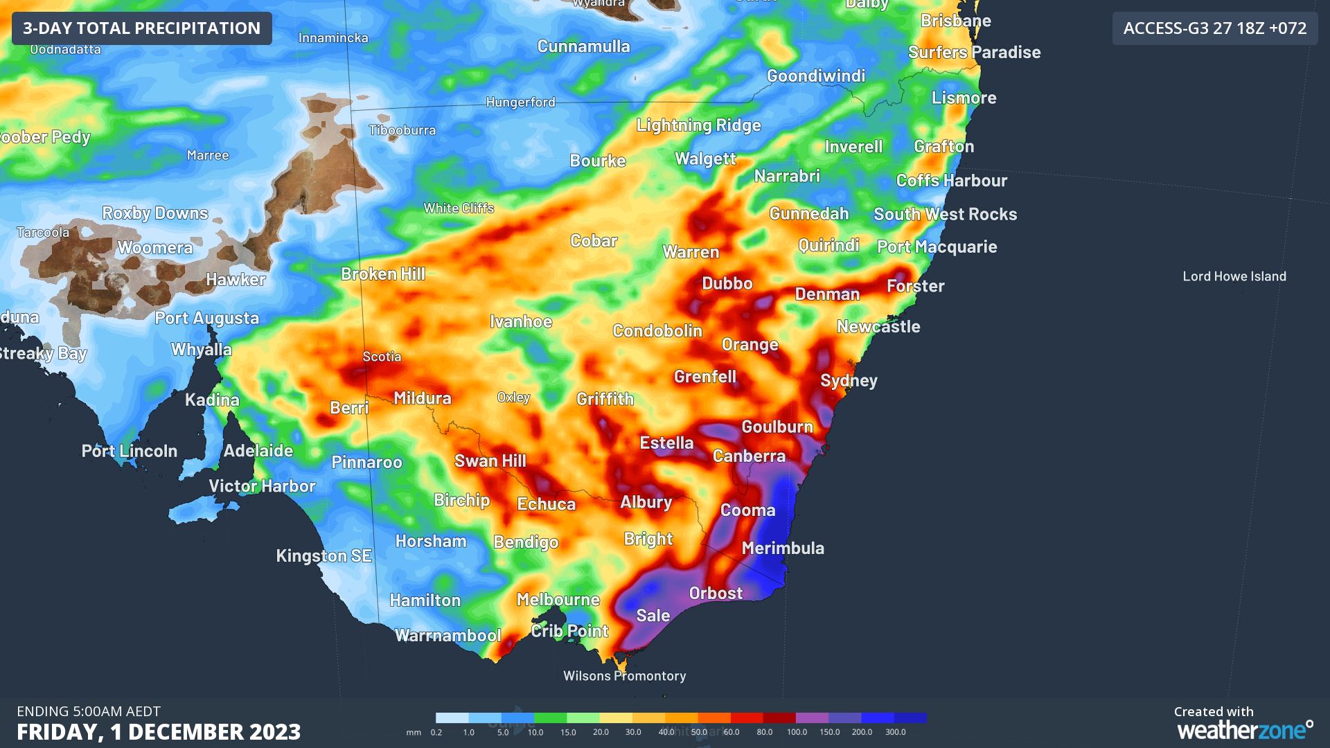
Images: Forecast accumulated rain between Tuesday morning and Thursday night, according to the ECMWF-HRES (top) and ACCESS-G (bottom) models.
At 12:30 pm AEDT on Tuesday, a severe weather warning was in place for heavy rain, flash flooding and damaging winds for the NSW coast and adjacent inland south of St Georges Basin. Flood watches were also in place for parts of the Illawarra Coast, South Coast Rivers, Inland Central West Rivers and South West Rivers in NSW, and in Gippsland and parts of North East and South West districts in Victoria.
Be sure to check the latest warnings for the most up-to-date information as this event unfolds.