
Sydney's wettest winter in 18 years
An exceptionally wet August caused Sydney to register its wettest winter in almost two decades, with the city nearly doubling its average rainfall for the season.
While winter started out with a drier-than-average June, rain started picking up in July and became torrential in August. The city’s monthly rainfall totals for winter 2025 were:
- June: 18.6 mm (long-term average: 132.5 mm)
- July: 159.0 mm (long-term average: 97.7 mm)
- August: 389.6 mm (long-term average: 79.9 mm)
Sydney’s seasonal total came in at 567.2 mm, which is well above the city’s long-term winter average of 310.1 mm. This made it Sydney’s wettest winter since 2007 and its 14th wettest winter in 167 years of records.
Last month’s 389.6 mm was also Sydney’s 3rd wettest August on record, beaten only by 470.6 mm in 1986 and 482.6 mm in 1998.
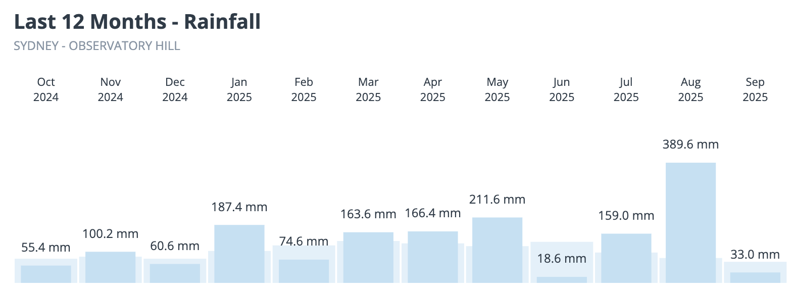
Image: Sydney’s monthly rainfall over the past 12 months, as of 9am AEST on September 2.
It’s no surprise that Warragamba Dam had to spill water towards the end of winter to release some of the water that had built up in Lake Burragorang, Sydney’s main water supply reservoir. At the start of spring, Warragamba Dam was sitting at 99% capacity.
Sydney also had a cool winter by modern standards. Despite a seasonal mean temperature that was close to 1°C above the long-term average, Sydney experienced its coolest winter in 10 years.
Most other areas in eastern NSW also had a wetter-than-average winter, while rainfall west of the Great Dividing Range was more hit and miss throughout the season.
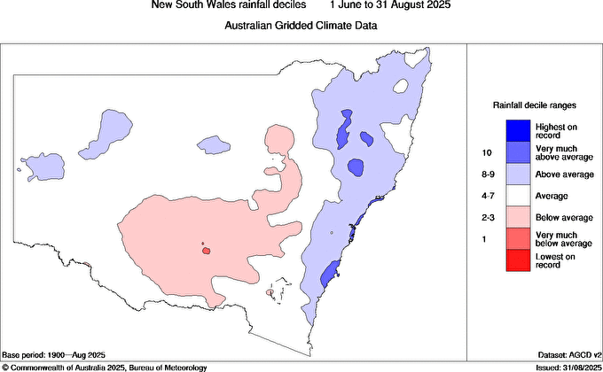
Image: Observed rainfall deciles in NSW during winter 2025. Source: Bureau of Meteorology.
Looking ahead, forecast models predict above average rainfall over most of NSW during spring, partially in response to a developing negative Indian Ocean Dipole (IOD). This increased rain and cloud cover may also suppress daytime temperatures over parts of the state, increasing the likelihood of near to below-average temperatures this spring.