
Sydney's muggiest day on record
Sydneysiders are sweating like a marathon runner in Marble Bar today as humid air from the Tasman Sea creates Darwin-like mugginess across the city.
Evaporated moisture from a tongue of abnormally warm water flowing near the NSW coastline is being carried into the Sydney Basin by onshore winds. This airborne moisture is making it harder for people’s bodies to lose heat through the evaporation of sweat, causing an oppressive muggy feeling that’s more common in tropical cities like Darwin or Cairns.
Meteorologists monitor atmospheric moisture by measuring the dew point, which is the temperature the air must cool to for condensation to occur. The more moisture in the air, the higher the dew point and the harder it becomes for our bodies to cool by sweating.
A typical 9am dew point in Sydney during January would be about 17ºC. On Thursday morning, Sydney’s dew point was hovering around 24 to 26ºC and reached 26.7ºC at 12:40pm, which is exceptionally high for any time of year.
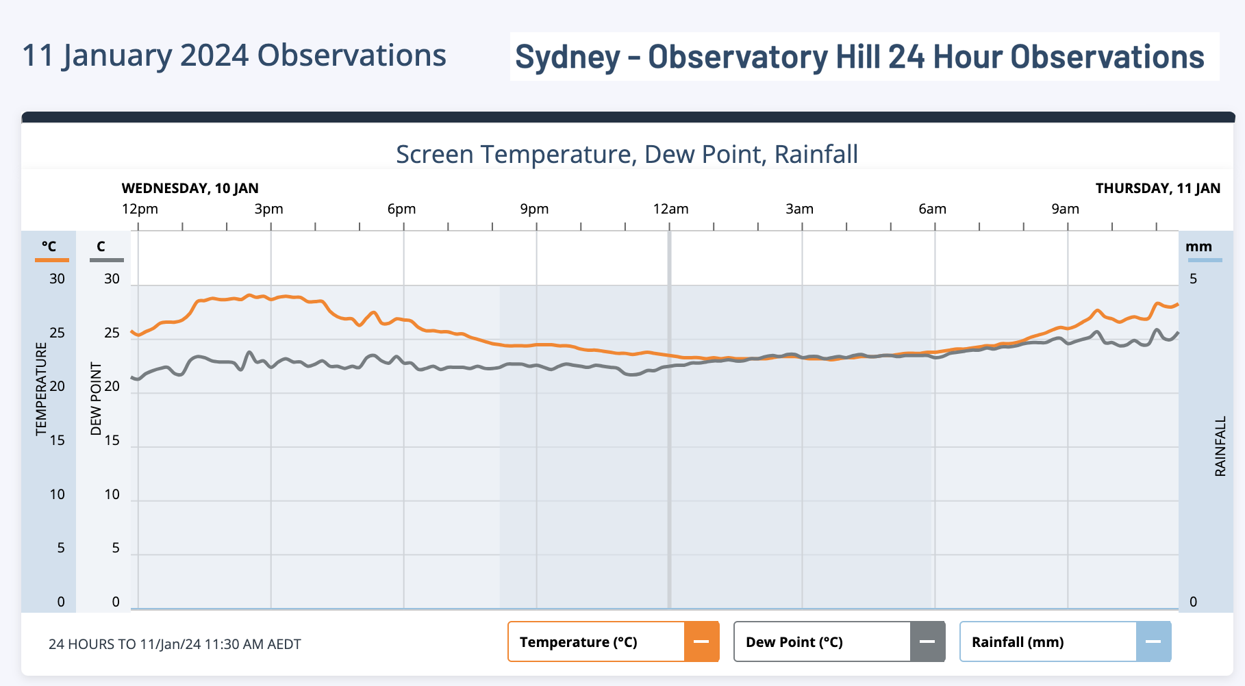
Image: Sydney's air temperature and dew point observations during the 24 hours ending at 11:30am AEDT on Thursday, January 11, 2024.
Sydney’s dew point of 24.6ºC at 9am AEDT was the city’s highest 9am dew point in 13 years, making this its muggiest morning since 2011. In the past 15 years, the highest 9am dew point in Sydney was 25.9C on November 14, 2011.
According to hourly historical observations from the Bureau of Meteorology, Sydney's dew point of 25.9ºC at 11am on Thursday was the city's highest hourly dew point on record. However, an analysis of extreme high dew points at Observatory Hill's weather station shows that the current site, which opened in 2017, is prone to higher dew point extremes than the old site. This may be due to the new site having more parkland in immediate proximity.
Thursday’s high dew points are making it feel 4 to 5ºC warmer than it is, with air temperatures in the mid to high twenties feeling more like the low thirties throughout the morning.
Today’s abundant atmospheric moisture and heat could give rise to localised showers and thunderstorms over Sydney. Unlike most storms that move into Sydney from the west or south, these storms could form seemingly out of nowhere directly above the Sydney Basin, or drift in from the east.
Keep an eye on the Sydney radar during the rest of the day to see if any storms are forming nearby.