
Sydney on verge of third wettest August on record
A week of relentless rain has put Sydney on the brink of having its third wettest August in 168 years of records.
Persistent onshore winds feeding into a series of low pressure troughs have caused persistent rain over eastern NSW this week. This stagnant weather pattern not only cause a string of wet days, but it also produced an entire month’s worth of rain in less than 24 hours for some places, including Sydney.
The Sydney Observatory Hill weather station, located next to the Harbour Bridge, registered 153.2 mm of rain between 9am on Monday and 9am on Friday. This is close to two months' worth of rain at this time of year.
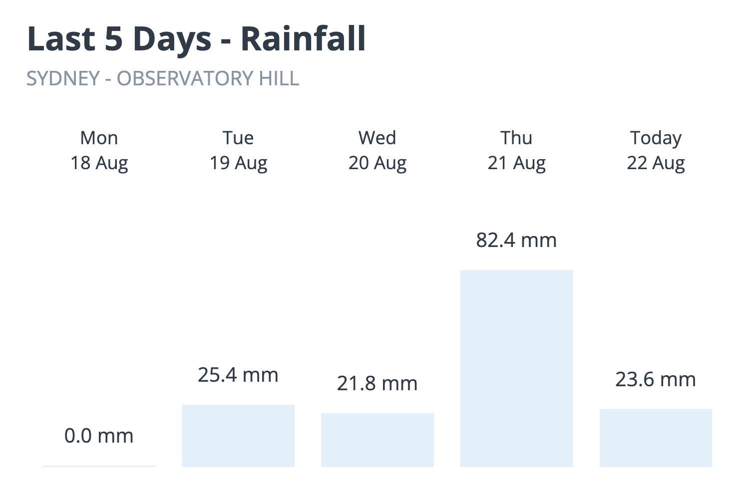
Image: Sydney’s rainfall observations over the last five days.
This week’s deluge brought Sydney’s running monthly total up to 368.8 mm as of 9am on Friday, making this the city’s fourth wettest August in records dating back to 1858. Here are Sydney’s top five wettest Augusts as of 9am on Friday, August 22, 2025:
- 482.6 mm in 1998
- 470.6 mm in 1986
- 378.3 mm in 1899
- 368.8 mm in 2025
- 303.2 mm in 1952
As you can see in the list above, another 9.6 mm of rain after 9am on Friday will be enough to make this Sydney’s third wettest August on record.
Warm seas and positive SAM to blame for all the rain
This week’s prolific rain has been the result of a unique combination of abnormal atmospheric and oceanic conditions near NSW.
Firstly, the belt of high pressure that typically sits over NSW at this time of year has been located further south than usual this week. This southward displacement of high pressure – which is called a positive Southern Annular Mode (SAM) - has resulted in persistent onshore easterly winds flowing over eastern NSW throughout week, instead of the offshore westerly winds that commonly occur in August.
Secondly, the onshore winds have been carrying more moisture than usual thanks to abnormally warm water in the Tasman Sea. Warmer seas cause more evaporation, which provides extra airborne fuel for rainfall. Sea surface temperatures are hovering around 20°C off the central NSW coast this week, which is 1 to 3°C warmer than average for this time of year.
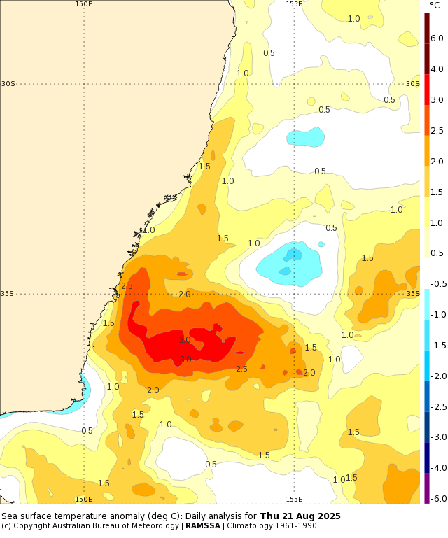
Image: Sea surface temperature anomalies off the NSW coast on Thursday, August 21. Source: Bureau of Meteorology.
Rain easing, flooding remains a risk
Unsurprisingly, this week’s unrelenting wet weather has resulted in flooding over parts of eastern and northern NSW, with a number of minor to moderate flood warnings in place on Friday afternoon. Inflows into Lake Burragorang also caused Warragamba Dam to start spilling in the early afternoon on Friday.
Rain will ease on the weekend and eastern NSW is expected to stay dry into the start of next week. This drying trend will allow floodwaters to gradually recede, but they will still pose a threat in some areas even after the rain has cleared. It can take days or event weeks for water to drain from inundated landscapes.
Be sure to check the latest flood warnings and road closures before heading out over the next few days and never enter floodwaters.