
Sydney hits one metre of rain four months ahead of schedule
The first half of 2024 has been remarkably wet in Sydney, with the city already amassing one metre of accumulated rain since the start of the year.
A combination of regular onshore winds, frequent rain-bearing weather systems and above average sea surface temperatures in the Tasman Sea have caused lots of rain in Sydney over the last five to six months.
The city has received above average rainfall in four out of the last five months and despite only being a few days into June, it has also already exceeded its June monthly average after a bout of torrential rain on the weekend.
This latest deluge, which included Sydney’s second wettest June day on record, tipped the city’s running annual total rainfall for 2024 above the one-metre mark.
As of 9am local time on June 4, Sydney’s running annual total was up to about 1020mm*. This is only the 14th time in 166 years of records that Sydney has seen more than one metre of rain by this point in the year.
In an average year, Sydney would usually reach 1,000mm of accumulated rainfall in October and pick up a little over 1,200mm in the entire year. In 2024, the city has amassed one metre of annual rain around four months ahead of schedule.
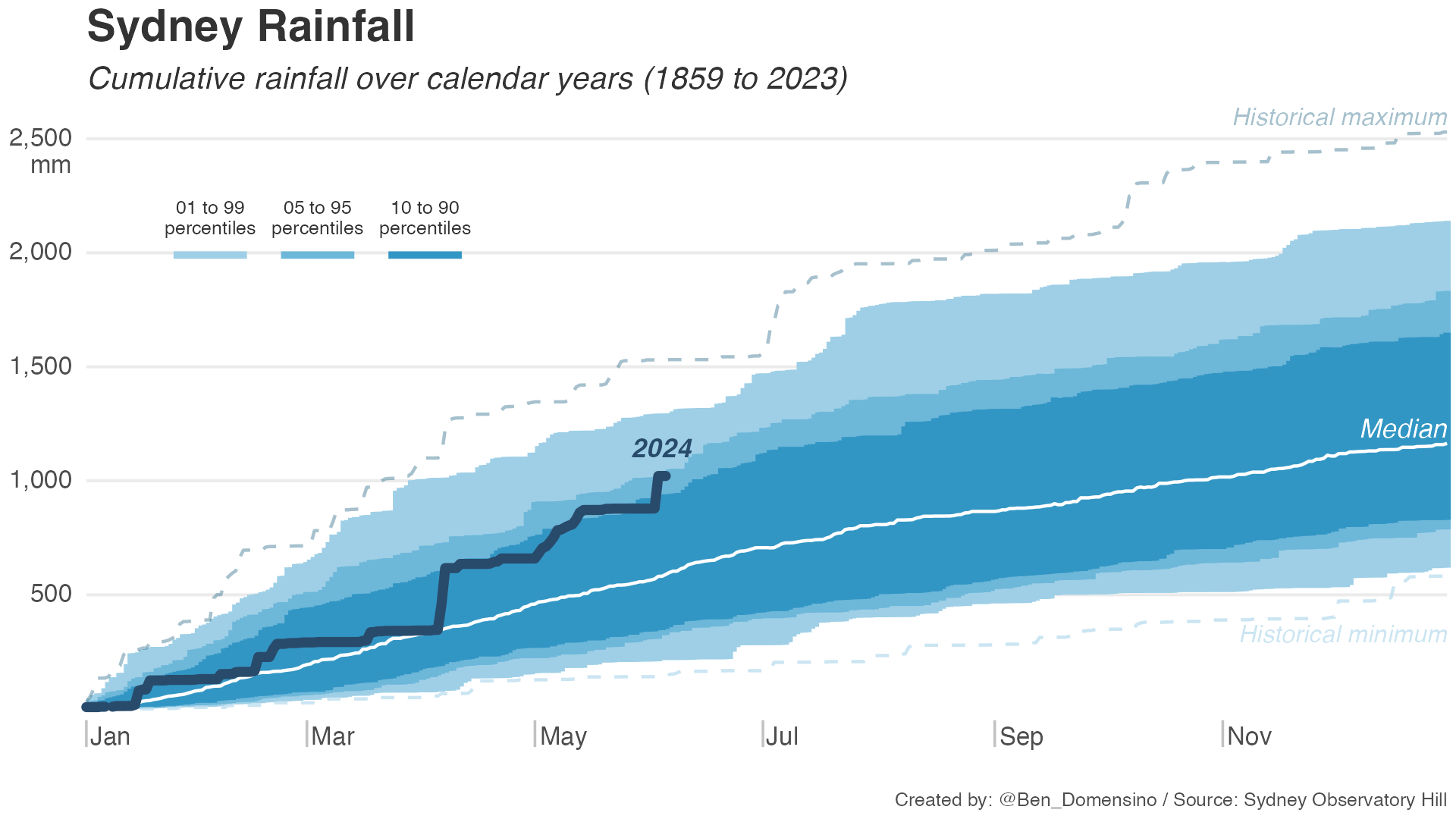
Image: Sydney’s cumulative year-to-date rainfall compared to all other years since 1859. Note that this graph uses estimated observations sourced from the Bureau of Meteorology for daily rainfall on February 20th and April 6th as data is missing on these days due to instrument failure.
This year’s running total of around 1020mm puts it in the top 2% of historical records up to this point in the year. However, it is far from unprecedented. In 2022, it only took three months for Sydney to exceed one metre of rain and by the end of May, the city had received more than 1.5 metres of rainfall.
The graph above shows that there have been a few bursts of heavy rain, most notably in April and June when more than 140mm fell in a single day. It is common for Sydney’s cumulative rainfall to increase in big steps like this, especially when low pressure systems or troughs cause persistent and heavy rain over the city.
Despite the hefty amount of rain Sydney has seen this year, the number of wet days hasn’t been remarkable. Sydney’s Observatory Hill weather station received measurable rain on about 65 out of 151 days between January and May, which is right on the long-term average.
*Some of the rainfall observations used to calculate Sydney’s year-to-date rainfall in this article were estimates from the Bureau of Meteorology. These estimates were to account for missing observations due to instrument failure at the Sydney Observatory Hill Automatic Weather Station. The following rainfall estimates were used:
- 160 mm in the 24 hours ending at 9am on April 6
- 35 mm in the 24 hours ending at 9am on February 20