
Sydney flash flooding after 100 mm in under three hours
Heavy rain and thunderstorms inundated parts of Sydney, the Illawarra and the Central Coast over the last 24 hours, with locally intense falls causing flash flooding in some areas.
A steady stream of moisture-laden easterly winds feeding into a slow-moving low pressure trough caused heavy and persistent rain along the central coastline of NSW on Thursday into Friday morning.
The heavy falls started in the Illawarra on Thursday before spreading north into Sydney from the afternoon and then extending further north to the Central Coast overnight into Friday morning.
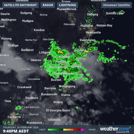
Image: Composite satellite, radar and lightning strikes over the Sydney region on Thursday night into Friday morning. Source: Weatherzone.
Some of the standout rainfall totals in the 24 hours to 9am on Friday included:
- 131 mm at Mount Pleasant near Wollongong
- 122 mm at Lidcombe in Sydney, including 105 mm in three hours and 73 mm in just one hour
- 122 mm at Darkes Forest
- 115 mm at Shanes Park in Western Sydney, including 74 mm in six hours and 45 mm in one hour
- 103 mm at Avalon
- 101 mm at Monda Vale
- 97 mm at Wamberal
The intense rain caused flash flooding in some areas. The NSW State Emergency Service responded to around 500 calls for assistance in the Sydney Metropolitan area during the 24 hours to 6am on Friday. In Fairfield, around a dozen properties were evacuated due to floodwater inundating homes.
While rain eased for most of central eastern NSW on Friday morning, further showers and thunderstorms are likely during the day as the trough lingers near the coast. Warnings will be issued if any falls become intense enough to cause further flooding, so be sure to keep up to date with the latest warnings in your area.