
Sydney cruising through warmest winter to date on record
Brett Dutschke
Despite a relatively chilly start to August, Sydney is having its warmest winter to date on record.
Sydney’s warmest winter to date on record
In June, July, and the first week of August, combining days and nights, the city has been running 2.3 degrees warmer than the long-term average spanning 167 years.
This winter so far, temperatures have been averaging 10.8 degrees for minimums, 19.5 degrees for maximums. Combining the city's overnight minimums and daytime maximums gives an average of 15.1 degrees so far. This is 0.6 degrees warmer than the previous record to August 8th, set in 2013.
Being warmer than average by as much as 2.3 degrees may seem like quite a lot. However, so far this century, all winters have been warmer than the long-term average. It's been quite a while since winter has been colder than the long-term norm. Most of us wouldn't remember it, 48 years ago, in 1978.
The city failed to cool below six degrees last winter and is on track to do the same this winter. Since temperatures have been recorded in 1859, the city has cooled below six degrees an average of 8 or 9 times each winter.
The heat-island effect (from heat-absorbing concrete) is one of the main factors why big cities don't cool as much as when they were smaller, or as much as their surrounding area.
Notably warm winter extending to western suburbs and much of NSW
In Sydney's far southwest, Camden, typically several degrees colder than the city on a winter night, is also experiencing a notably mild winter. Camden has only chilled below zero degrees once, on July 24th. This is the longest it has taken to dip below freezing in 30 years. The first frost of the season is typically in June.
It's been a similar story for much of New South Wales, even much of eastern and northern Australia.
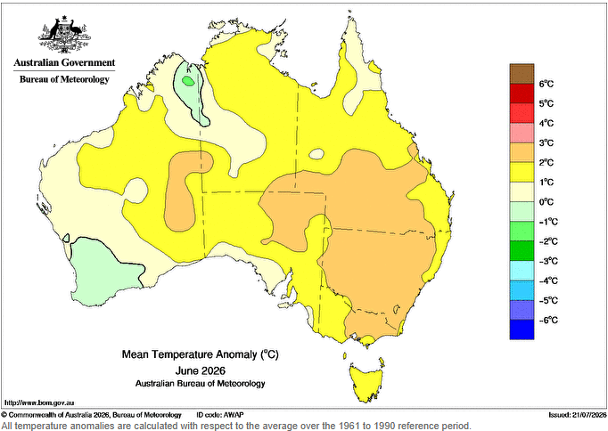
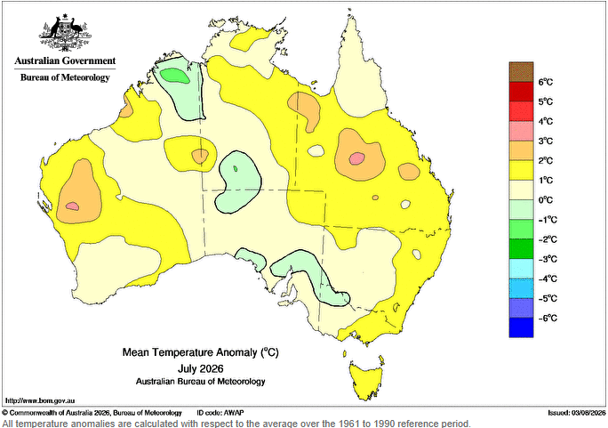
Images: Mean temperature anomaly for June and July 2026. Source: Bureau of Meteorology
An early look at the remainder of winter
Looking ahead, a few wintry cold fronts in the next week will keep Sydney fairly chilly and breezy, most likely causing the running seasonal-average temperature to drop a little. By mid-August, fronts should become weaker and less frequent, allowing for a few warmer spells to develop in between.
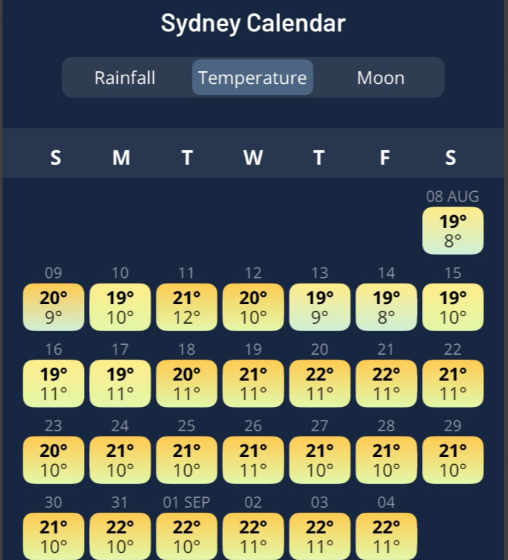
Image: Sydney's next 30-day temperature forecast on the Weatherzone app.
By the end of this month, Sydney and other parts of eastern and northern Australia are a fair chance to have achieved their warmest winter on record.
Note to media: You are welcome to republish text from the above news article as direct quotes from Weatherzone. When doing so, please reference www.weatherzone.com.au in the credit.