
Sweet relief for Perth after hottest early-March heat in decades
Hot conditions have gripped Perth during the first week of March, although a cooler southerly change on Monday should finally bring relief.
At Perth Airport, every day since Tuesday has exceeded 36 °C, culminating in 41.5 °C on Saturday – about 11.7 °C warmer than the long‑term March average of 29.8 °C, and the airport’s hottest day this late in the season in more than two decades (eclipsing its previous late‑season benchmark from 23 March 2005). Perth Metro also sizzled – Saturday’s 40.3 °C was 10.6 °C above average, making it the hottest day this late in the season since 2012. Both sites also recorded four consecutive days above 36 °C, reflecting a notable run of hot days for this time of year.
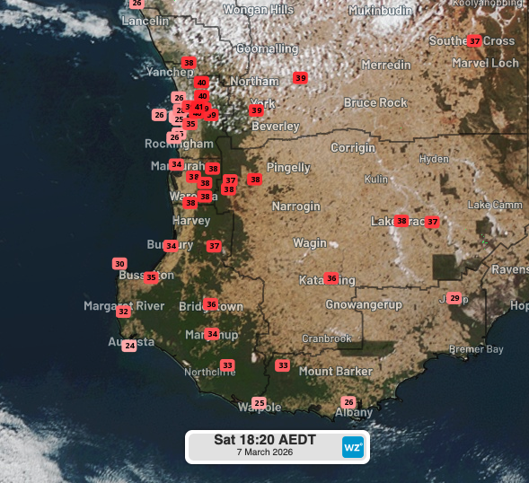
Image: Observed maximum temperatures at 3:20pm AWST across parts of southwest WA on Saturday, March 7, 2026. Weatherzone.
The heatwave was driven by a high in the Bight directing north to northeasterly winds into a west coast trough. This circulation drew hot desert air towards the west coast and delayed/suppressed the cooling sea breeze, allowing temperatures to soar. The hot airmass also affected large parts of WA. On Saturday, temperatures exceeded 40 °C at several inland stations, including Dalwallinu (40.8 °C), Badgingarra Research Station (40.5 °C) and Cunderdin Airport (40.9 °C). These readings are the warmest this late in the season since the early 2000s for many of those sites. Other northern towns such as Paraburdoo (43 °C), Newman Airport (41.3 °C), Telfer (41.1 °C), Marble Bar (40.7 °C) and Mardie (40 °C) registered their highest March maxima in at least 24 years.
Relief on the way, but more heat could follow
A change is on the horizon. The trough near the west coast is forecast to shift east on Monday as a cold front clips the southwest, bringing a gusty southerly and cooler air through the afternoon. A strong ridge of high pressure will then build over southwest WA, causing fresh to strong winds and much milder temperatures early to mid-next week. Maximums in Perth should drop into the mid‑to‑high 20s during this period. By Thursday, however, as the high moves into the Southern Ocean, easterly winds are likely to return and a new west coast trough may redevelop, potentially bringing another burst of heat with temperatures above 30 °C by next weekend and into early to mid‑next week.