
'Super El Niño' values possible this summer, fall
Sea-surface temperatures in the tropical Pacific Ocean are rising rapidly as an El Niño signal emerges, with forecasts suggesting that that this year’s El Niño could become one of the strongest on record.
Sea-surface temperatures in the tropical Pacific Ocean have been rising since the start of 2026. The current trajectory and forecasts have an El Niño taking shape over the next few weeks, and later in the year possibly becoming one of the strongest El Niño events on record.
The Climate Prediction Center (CPC) has issued an El Nino Watch as they expect ocean conditions to transition from neutral (neither El Niño nor La Niña) into an El Niño state over the next month. El Niño is the positive side of the El Niño Southern Oscillation (ENSO), when sea-surface temperatures are significantly higher than normal in the tropical Pacific Ocean.
Last winter’s brief La Niña, which peaked between November and January, has been weakening in recent months and we are now heading into El Niño territory.
Forecast models suggest that the upcoming El Niño may become a very strong or ‘Super’ El Niño, meaning sea surface temperatures in the central tropical Pacific Ocean are at least 2.0°C warmer than average. The most recent model forecasts have ocean temperatures peaking around October and November, before a seasonal drop in temperatures heading into 2027.
Based on current forecasts, the El Niño of 2026 may become one of the strongest El Niño events in our short, recorded history since 1950. However, it is too early to know exactly how strong it will become.
Current ocean temperatures below the surface tend to mirror some of the strongest El Niño events like 2015 and 1997. Temperatures deep below the ocean surface are already 5°C above normal at a depth between 100 and 150 meters, which has been spreading towards the surface over the last several months. Large-scale ocean churning processes are likely to bring that water to the surface over the next several months, producing the super El Niño.
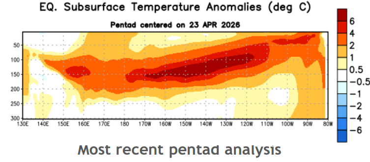
Image: Temperatures below the surface in the tropical Pacific Ocean are extremely warm, with anomalies more than 5°C above normal. Source: CPC.
Another way of measuring ENSO is by using the Southern Oscillation Index (SOI), a measure of the difference in pressure between Tahiti and Darwin, Australia. Sometimes, these atmospheric influences precede or follow changes in sea-surface temperature, and can signal whether the atmosphere is responding to the changes in sea-surface temperature. Indeed, monthly SOI values have fallen near and below a -8 (the threshold for El Nino) since April 12. Thus, the atmosphere has already started to respond to the changing sea-surface temperatures.
Those across the Americas have probably noticed the change with a cooler and stormier weather pattern in North America, and the early dissipation of wet-season thunderstorms in central Brazil. Not all of this is the result of the building El Niño, but will be reinforced by it over the next several months.
History shows us that developing Super El Nino events favor a milder, stormier pattern east of the Rockies in the U.S. Previous strong to very strong El Nino years (e.g. 2023, 2015 and 1997) featured a milder summer with above-normal precipitation across a lot of the country. However, not all of these years were the same, with very cool temperatures and more widespread and average precipitation in 1997, a colder pocket centered on Midwest with heavy rainfall in 2015, and more fragmented temperatures and precipitation that favored some areas and avoided others in 2023.
Impacts are also starting to be felt in other areas of the globe and will expand as the months go by. Dryness and increasing drought concerns are forming in Australia and are forecast for Argentina over the next few months.
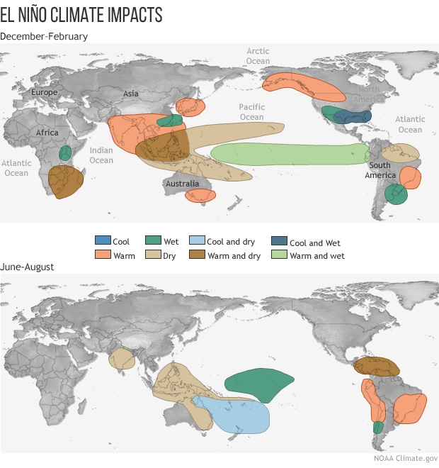
Image: Weather effects due to El Niño are global and different depending on the time of year. Source: NOAA.
The effects will increase during the Northern Hemisphere late fall and winter, including a wetter southern tier and overall warmer winter in the U.S., warmer temperatures in Japan and India, hotter and drier conditions for South Africa and Australia, and an eventual turn to wetter conditions for Argentina during their summer.