
Summer is coming

The clouds have broken over the southeast of the country and the coming week will see more summer-like conditions develop in all the southeast capitals.
Adelaide, Melbourne, Canberra and non-coastal Sydney will all top 30 degrees today, Sunday 10th. Adelaide has already racked up a couple of above 30 degree days since Friday but this will be the first time Melbourne and Canberra have surpassed the temperature since December 27th/28th last year. Coastal Sydney won’t be as warm - as is typical - but it will still reach the high twenties.
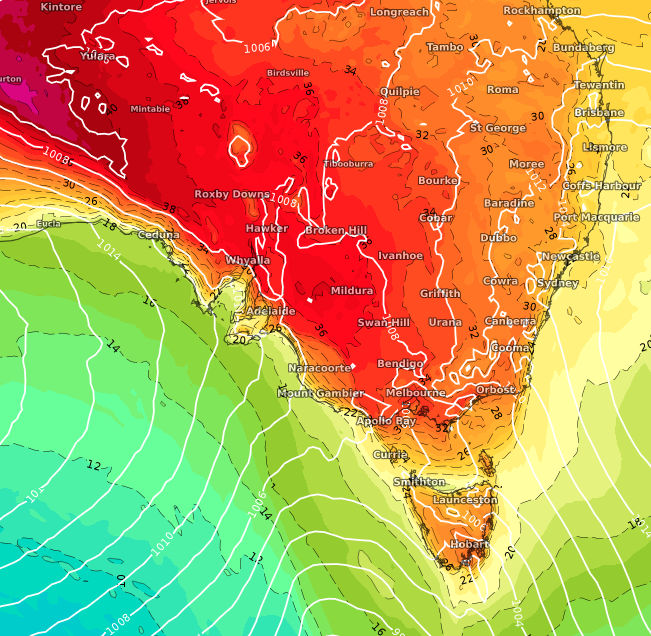
Image: Mean sea level pressure in hPa (white) and temperature in degrees Celsius (coloured) at 1000 hPa showing the warm tongue of air stretching over southeast Australia, according the the ECMWF model at 0600Z Monday 11th January, 2021.
This warm turn follows a remarkable string of cooler weather in December and early January, particularly for the latter half of December in Melbourne, where all days except three - the 17th, 26th and 27th - were multiple degrees below average. Averaged over the whole month, it was the coolest December (based on daily maximum temperatures) since 2001 for the city. For western Sydney and Canberra, it was the coolest December since 2011; for Adelaide and coastal Sydney, since 2014.
Following the heat today, Canberra and western Sydney will remain hot — with temperatures in the thirties — until Saturday 16th, while Adelaide and Melbourne will be more variable.
A cool change will arrive in Adelaide late on Monday 11th, before progressing onto Melbourne, though temperatures will bounce back quickly before a more substantial change arrives late Wednesday to end the spell of heat in the two cities.
Wednesday and Thursday will see the heat peak further east over Canberra and Sydney, when temperatures exceeding 35 degrees are likely away from the coast. The likely stormy change will then cross during Thursday and Friday, bringing a couple of warm, humid and sometimes showery days before a cooler period leading into the weekend and early next week.
This will mark the most significant spell of warm temperatures for the southeast since at least mid-December.