
Strong, cold, snowy system to chill the southeast
The coldest outbreak of what has been a relatively mild autumn is heading to southeastern Australia from midweek, with the strong likelihood of widespread showers, small hail, strong winds, and snowfalls at higher elevations.
The cold front will sweep across the southeast on Wednesday and Thursday, and will be the second punch of a two-pronged weather system which has already left its mark, with record May rainfall totals recorded at several locations in the 24 hours to 9am Monday.
Let's break down this major weather system into its two distinct phases.
Phase 1: Heavy inland rain ahead of weak cold front
Over the weekend and into Monday morning, significant rainfall totals were recorded in numerous locations across Victoria, New South Wales, and northern Tasmania, as a series of rainbands arrived from the north, driven by a low pressure system centred over waters just south of the SA/Vic border.
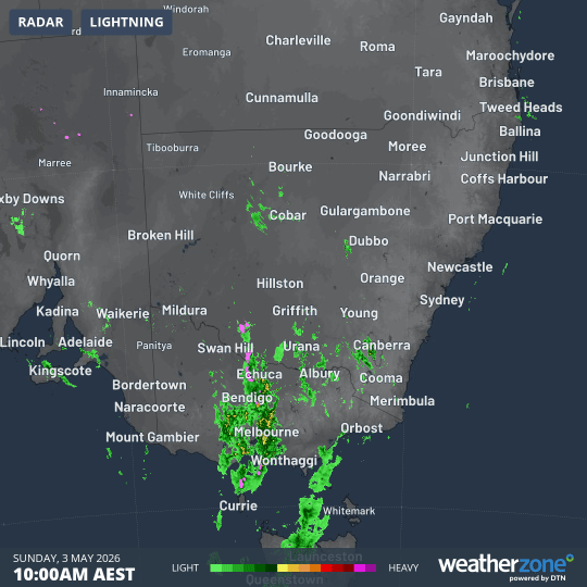
Image: Rain radar across SE Australia in the 12 hours to 10pm on Sunday, May 3, 2026. Source: Weatherzone.
Notable rainfall totals in the 24 hours to 9am Monday included:
NSW
- 106mm at Thredbo Top Station, which was its wettest May day on record (records since 1970).
- 61mm at Cabramurra, the wettest day in any month since 2024 for this reliably damp Snowy Mountains site (records since 1997).
- 48mm at Forbes Airport, the site's wettest day in any month in more than two years (records since 1996).
VICTORIA
- 81.8mm at Mt Hotham, with 66.2mm at Harrietville at the foot of the road to Hotham (where totals are often much less than half than what’s received at the top of the mountain).
- 78mm at Mt Buffalo Chalet.
It’s also worth noting that numerous towns in central and western Victoria registered healthy falls around 20mm in the 24 hours to 9am Sunday, with several locations registering their highest daily rainfall totals for May in six years or longer.
Eastern NSW is now receiving rain from a rainband stretching from the northwest of the state to the southeast, with a few showers falling in Sydney.
Later this Monday, slightly chillier air will pass through the southeast. Melbourne has topped 20°C on 13 of the last 14 days, and could again reach a mild 20°C this Monday ahead of a cooler maximum of 18°C on Tuesday.
But much colder weather lies ahead.
Phase 2: Showers, wind, snow with a much stronger cold front

Image: Predicted mean sea level pressure and precipitable water according to the ECMWF model for SE Australia at 4am on Friday, May 8, 2026. Source: Weatherzone.
The weak front passing through the southeast this Monday will establish a westerly stream, which will allow polar air to push northwards with the second, much stronger cold front due later this week.
The coldest air arrives over the mainland alpine region on Thursday, with snow projected to fall as low as about 900 metres. Snow could also fall on the tablelands below the mountains in parts of Vic, NSW and the ACT.
At this stage, around 20cm of snow is projected to accumulate in the Victorian and NSW ski resorts. This will almost certainly melt before the traditional season opening in early June (June 6 this year). Generally speaking, May snowfalls do not contribute to the season’s snowpack unless they arrive in the last few days of the month.
Is this the first major snow event of autumn 2026?
Tasmania has already seen several significant snowfalls already this autumn, while the mainland saw an unseasonable snowfall in late March, but this will be the strongest system yet for the mainland in the 2026 autumn.
Melbourne will feel the chill on Thursday with a maximum of just 12°C expected. Cool maximums will then persist right through to at least Sunday.
Hobart can expect a top of just 13°C on Thursday, while Canberra is forecast to reach just 10°C, with snow likely on the nearby ranges and a frosty weekend to follow.