
Southeastern Australia's driest January in 17 years
In news that won’t surprise residents of Melbourne, Adelaide or plenty of other places in Australia's most heavily populated corner, southeastern Australia just had its driest January since 2009.
It was also the region's second-driest start to the year since 1965, with January rainfall down by 23.14mm on the long-term mean, when averaged across all official weather stations in the region.
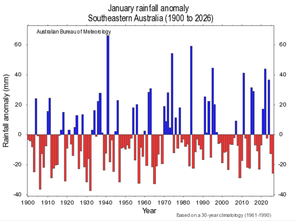
Image: January rainfall anomalies across southeastern Australia dating back to 1900. Source: BoM.
How dry has it been?
The chart below shows rainfall deciles across Australia for January 2026. As you can see, the largest area of red (denoting very much below average rainfall) is located in the southeast of the country.
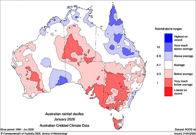
Image: Australian rainfall deciles in January, 2026. Source: BoM.
The dry January came after much of the southeast also endured below-average December rainfall, making for significant rainfall deficiencies in the first two months of the 2025/26 summer. For example:
- Adelaide (SA) had just 2.8mm of rainfall in December (average 25.9mm) and absolutely no rain in January (average 29.1mm).
- Melbourne (VIC) had 27.8mm in December (average 58.4mm) and just 1.6mm in January (average 48.0mm).
- Wagga Wagga (southern NSW) had 24.8mm in December (average 46.4mm) and just 2.0mm in January (average 43.5mm).
- Launceston (northern TAS) had 17.4mm in December (average 47.3mm) and just 3.2mm in January (average 44.5mm).
There were, of course, some areas, that had above-average or even exceptionally heavy January rainfall, such as the NSW South Coast and a small patch of the southwest Victorian coastline along the Great Ocean Road where cars were swept away in flash flooding on January 15.
But the overall picture was dry, and the outlook remains that way for the immediate forecast period. Both Adelaide and Melbourne can expect no rainfall for the rest of this week, give or take the chance of a brief light shower in Melbourne.
The short-term forecast is also dry for inland parts of the southeast, although there are signs of instability as the week progresses as tropical air pushes south.
At this stage, the potential for rainfall associated with thunderstorms looks more likely for inland NSW than further south and west in SA and Vic.