
Snowy Canberra chilling through its coldest day in four years

Canberra has been experiencing its coldest day in four years, struggling to a high of just 7.5 degrees after spending the middle of the day at about three degrees when rain turned to snow in the city.
Brisk wind which has occasionally gusted in excess of 50km/h has made it feel below freezing at times.
Even with the city warming a bit during the afternoon during glimpses of dry sunshine, a maximum temperature as high as 8.3 degrees would still make it the coldest day since July 2016.
The weather system responsible for this cold is an intense pool of cold air that has reared up from Antarctica way, spun across southeastern Australia. It has been bringing widespread wintry showers, small hail and lowland snow to Tasmania, Victoria, NSW and the ACT.
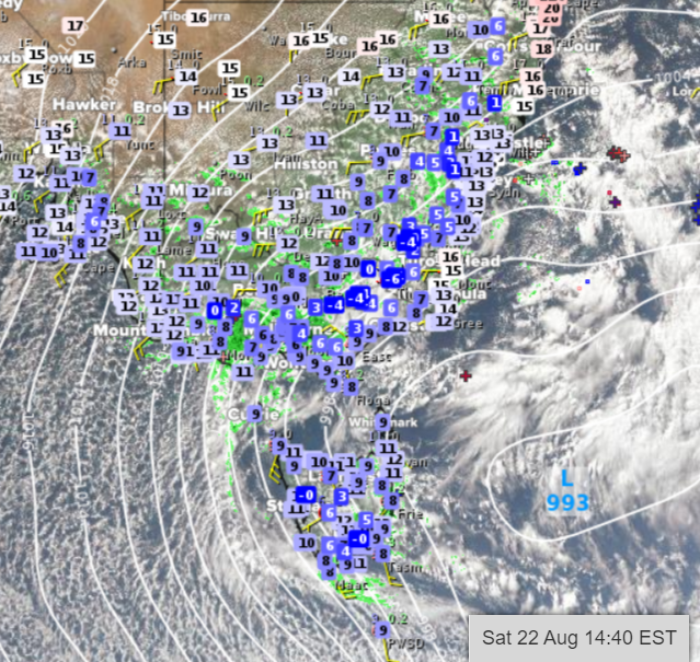
Observed temperatures, visible satellite image, radar, lightning strikes, GFS isobars for Saturday afternoon
Snow has fallen lower than 500 metres above sea level in Tasmania, Victoria and southern NSW, as low as about 600 metres in central NSW and about 1000 metres in northern NSW. Snow depths at the ski fields have reached new season highs
It has also so far been the coldest day in 12 years in Eildon (3.6-degree maximum) and four years in Hunters Hill (0.7-degree maximum), Tuggeranong (8.0-degree maximum), Braidwood (7.7-degree maximum) and Perisher Valley (-3.3-degree maximum). These temperatures are four-to-eight degrees colder than average.