
Snow-vember!
Heavy snow has fallen in Tasmania, Victoria, New South Wales, and the ACT – with even a light dusting in SA – as the coldest air of the November polar blast surged through southeastern Australia overnight.
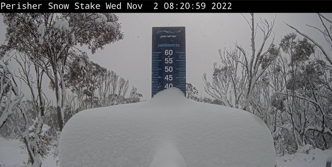
Up to 35 cm was reported in the NSW Snowy Mountains, and when you look at the date-stamped snow stake at Perisher ski resort this morning, that seems about right.
Heavy snow also fell in the Victorian Alps, with similar depths to NSW while snow is coating the mountains around Canberra.
We wrote earlier this week about this front, and mentioned how Antarctic airmasses can sneak their way onto Tassie and southern mainland Australia in any month of the year.
But we also said that the strength of this particular late spring cold front is quite remarkable, and so it has proven, with snow falling in places at lowish altitudes well beyond the high country.
Yesterday, snow was reported around Ballarat in central Victoria.
Snow in Barkstead near Ballarat earlier!
— Victorian Storm Chasers (@VicStormChasers) November 1, 2022
🎥 Janet L#StormHour #weather #snow #SevereWeather
Licensing available via @SevereWeatherAU pic.twitter.com/3EWZ3zEQbD
And this morning, snow has been reported around Orange, on the NSW Central Tablelands.
Feels like -7.8 and light snow in Orange. Adorable! pic.twitter.com/DWdVqSWMcf
— Steph Gardiner (@steph_gardiner) November 1, 2022
These are the sorts of places that expect a light dusting at least once or twice each winter, but unlike the mountain regions, snow at this time of year is extremely unusual.
As you’d expect with such a cold weather system, temperatures plummeted well below zero overnight last night as the airmass began to dry out. The lowest recorded temp in the four states mentioned was:
NSW: -6.1°C at Thredbo Top Station
VIC: -5°C at Falls Creek
ACT: -5°C at Mt Ginini
TAS: -3.4°C at kunanyi/Mt Wellington
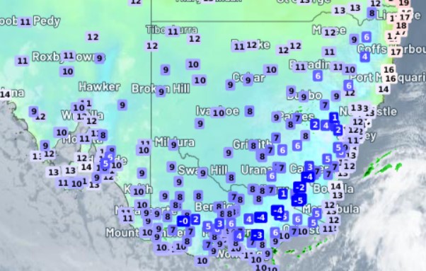
As you can see below, it was chilly pretty much everywhere for November. These were the temps at 7:30am on Wednesday across the southeast mainland. Not warm, and another cold night can be expected tonight.
For the record, last night was the coldest November night in 16 years in Sydney and five years in Melbourne, while yesterday was Melbourne's coldest November day in 16 years
But there is good news on the horizon for those seeking warmer weather.
A spell of fine weather should set in for the next week or so for much of the country, especially in the areas that were most severely impacted by this week's unseasonable cold spell, as winds swing around to a northerly aspect.
Melbourne and Adelaide in particular can look forward to some lovely weather early next week, with tops in the mid-to-high 20s in Melbourne, while temps should reach the low 30s in Adelaide for the first time this spring.
That'll make a nice change from yesterday, where temps were in single digits in the mid-afternoon in both cities as the heaviest showers passed through.