
Snow, storms and severe fire danger on Thursday

Snow will fall in southeastern Australia today while hot and windy weather causes severe fire danger ratings in four states and territories.
Spring is a time of contrasting weather in Australia, when cold and warm air clash over our continent and temperatures can vary wildly from state to state.
Today will be a prime example of this, as a pulse of cold air will sweeps over the nation's southeast and a large mass of hot air spreads across parts of northern and eastern Australia.
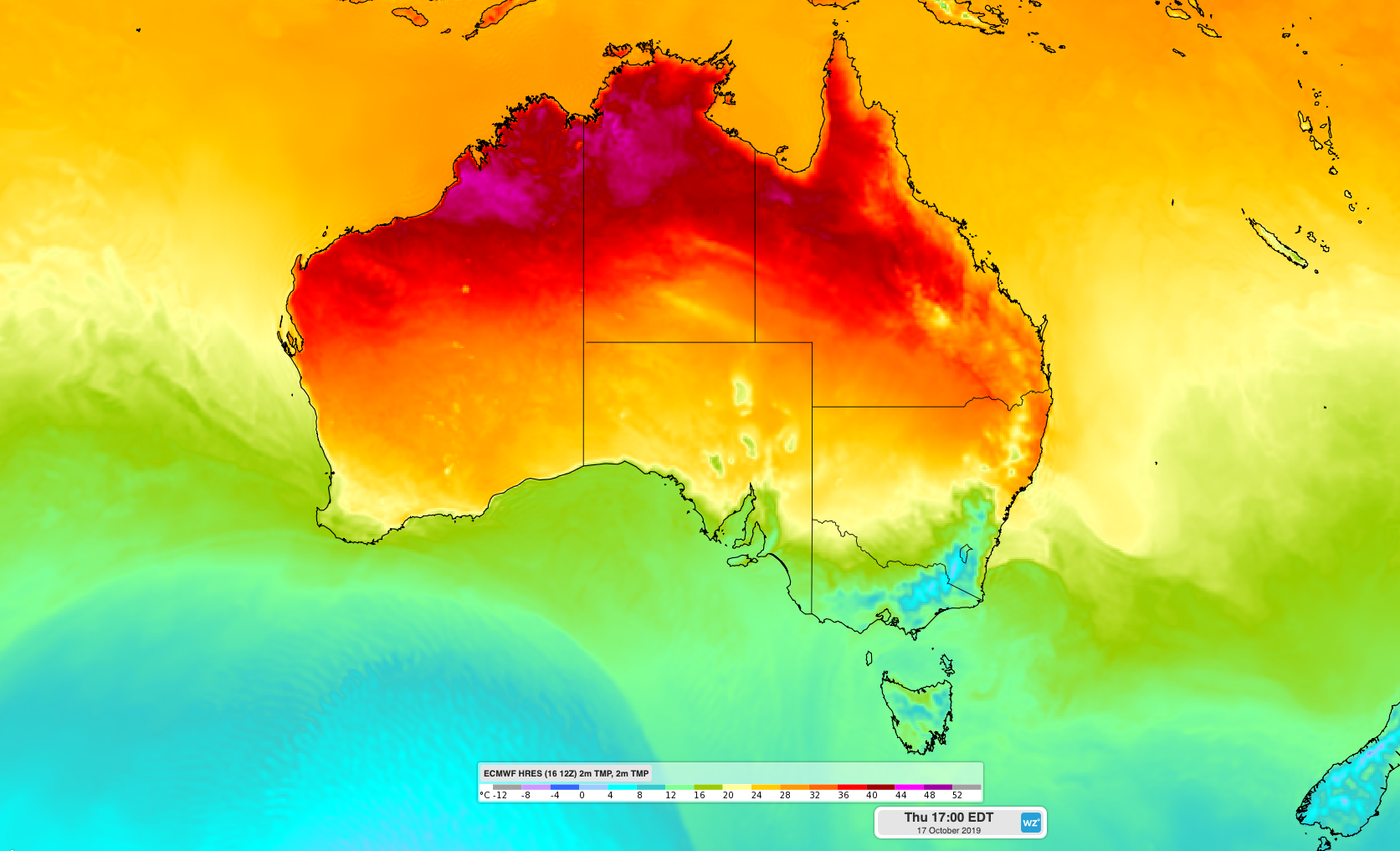
Image: Forecast surface temperature on Thursday afternoon, showing hot air over northern and eastern Australia and colder air over the nation's southeast.
Snow is forecast to reach down to about 800 metres elevation in Victoria this morning, with flakes already settling at Mount Buller shortly after sunrise. Snow will also fall across parts of the alps in NSW and possibly some of the higher peaks in the ACT later today.
But while it's feeling wintry in the nation's southeast, temperatures are forecast to reach the high thirties and low forties in parts of northern and eastern Australia on Thursday. Grafton and Goondiwindi are both forecast to reach 36 degrees during the afternoon.
Very High to Severe fire danger ratings are forecast for much of eastern and northeast NSW and parts of southeast, central and northern Queensland on Thursday.
Total fire bans have been issued for six districts of northeast NSW, where a number of large fires have already occurred this season. According to the NSW Rural Fire Service, 64 homes were destroyed last week by bushfires in northern NSW.
Temperatures will be even higher in northern Australia on Thursday, with the mercury tipped to reach 40 degrees at Adelaide River, to the south of Darwin. Across the border, parts of Western Australia's Kimberley and Pilbara Districts are forecast to reach 41 to 43 degrees.
Very High to Severe fire danger ratings have been forecast across a broad area of northern WA and northern parts of the NT on Thursday.
The interaction of these hot and cold air masses over Australia will also result in thunderstorms over parts of Queensland and NSW this afternoon. Severe thunderstorms are possible in central and southeast Queensland and far northeast NSW.
Visit https://www.weatherzone.com.au/warnings.jsp for the latest warnings.