
Severe thunderstorms strike WA’s southwest ahead of subpolar air mass
A significant trough and cold front impacting southwestern WA today, Sunday 27th July, sparked a burst of severe thunderstorms earlier this morning, bringing heavy rainfall and damaging wind gusts to parts of the southwest. Trailing the front, a surge of subpolar air is expected to spread across the area, making Monday 28th a standout cold day this winter.
This event is one of many in a notably active weather pattern observed in recent weeks, characterised by frequent strong cold fronts and severe thunderstorm outbreaks across the region. Among the most significant was the tornadic thunderstorm that impacted Perth on Wednesday 23rd July.
As of 10:00 am WST, severe weather warnings for damaging winds and heavy rainfall with thunderstorms were in place for parts of the Lower West and Southwest districts, including Perth. The warnings were cancelled at 10:36 am WST as thunderstorm activity temporarily eased. Satellite and radar imagery from early this morning depicts heavy rain and thunderstorm activity across the southwest corner of the state, associated with embedded thunderstorm cells within the pre-frontal environment
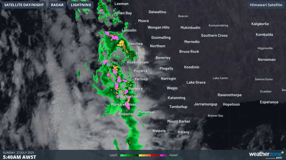
Image: Visible satellite showing the convective activity over southwest WA on the morning of Sunday, 27th July, 2025.
Several weather stations recorded substantial rainfall accumulations associated with the pre-frontal trough this morning including:
- 75 mm in the 6 hours to 06:10 WST at Wilyabrup
- 64.6 mm in the 6 hours to 05:40 WST at Harman South Road
- 33 mm at Margaret River – highest daily July total since last year
- 29 mm at Cape Leeuwin – highest daily July total since last year
- 28 mm at Busselton Airport
- 26 mm at Cape Naturaliste
- 12 mm at Swanbourne in 2.5 hours to 9am WST
- 10.4 mm in Perth in the 1 hour 40 minutes to 09:00 WST
Wind gusts have also exceeded damaging thresholds in exposed coastal areas ahead of the front, with a peak gust of 98 km/h recorded at Cape Naturaliste just after 5am WST Sunday, which was the strongest gust for the location since last August. Other notable gusts include 74 km/h at Rottnest Island and 67 km/h at Busselton Jetty, both occurring before dawn.
Following the frontal passage this weekend, a vigorous southerly airstream is forecast to transport cold maritime air from subpolar latitudes into southern WA. Backward trajectory analysis using NOAA’s HYSPLIT model indicates the origin of this airmass lies south of 50°S, within the Southern Ocean.
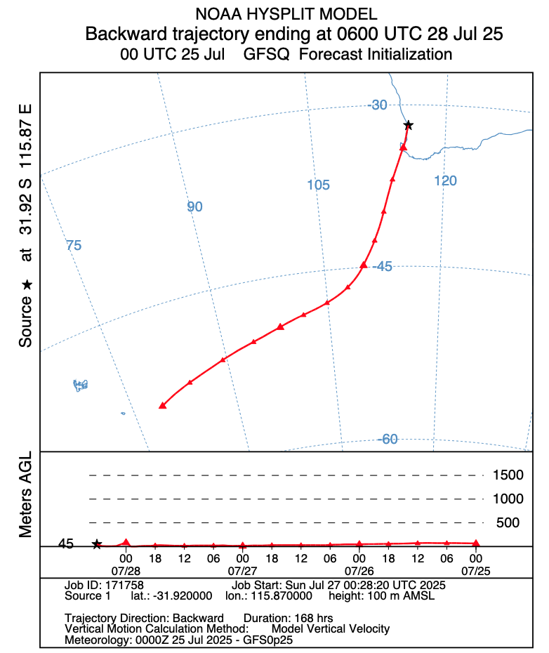
Image: NOAA HYSPLIT 7-day backward trajectory showing subpolar air origin affecting Perth on Monday, 28th July, 2025.
This synoptic setup closely resembles the previous event on Thursday 24th July, when Perth recorded its coldest maximum temperature in three years (14°C), and numerous stations across southern WA reported their lowest maximums in 2 to 7 years.
Maximum temperatures in Perth on Monday 28th July may struggle to exceed 14°C, potentially ranking as the city’s second coldest day of July 2025. Many locations across the Southwest Land Division and adjacent southern districts along the Bight coast are also expected to record well below-average daytime temperatures, particularly under post-frontal cloud cover and a persistent, very strong southerly flow.
What's next for the system?
The low pressure system associated with the cold front and trough will move closer to the Esperance coast on Monday, driving increasingly strong winds across southern WA. Damaging gusts, potentially exceeding 100 km/h, are possible across southern districts—particularly along the South Coastal and South East Coastal districts—during Monday and into early Tuesday. These conditions will be accompanied by periods of heavy showers and isolated thunderstorms. A high pressure ridge is forecast to build mid-week, leading to a gradual easing of winds and shower activity.
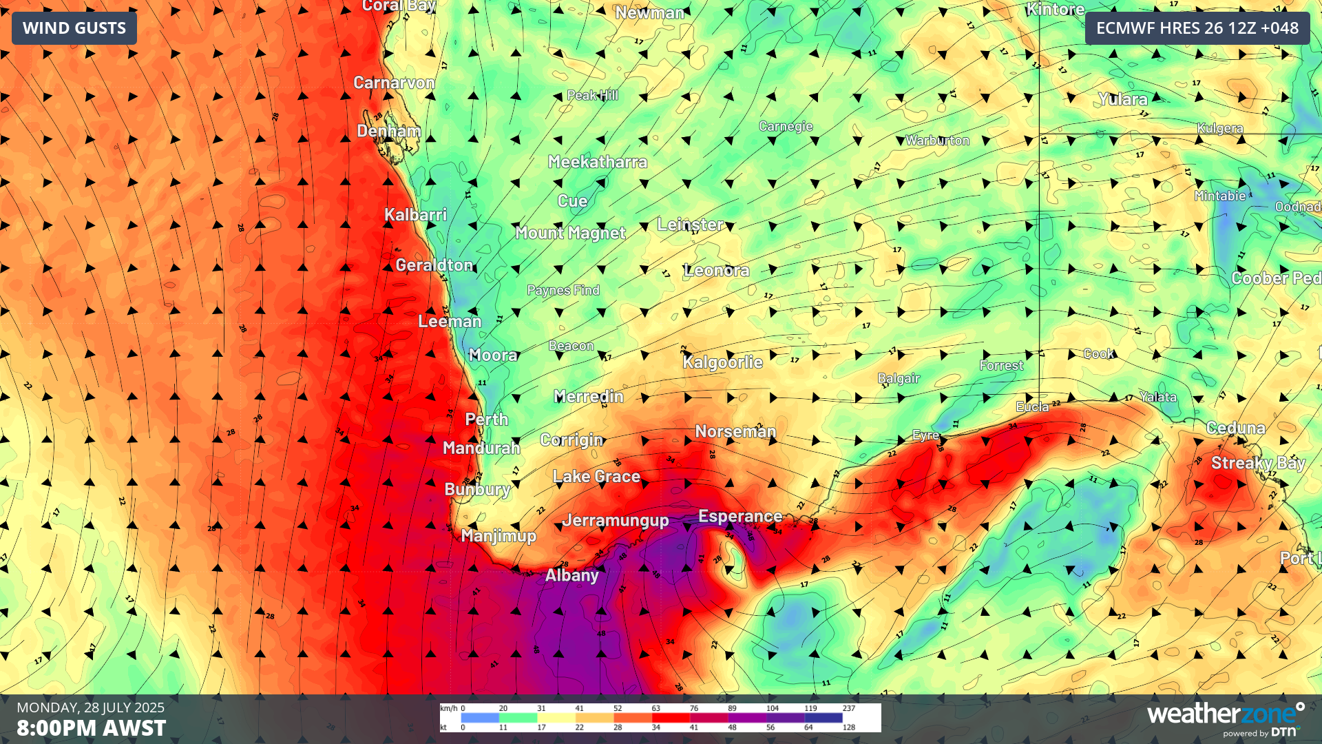
Image: Modelled wind gusts at 8pm WST on Monday, 28th July, 2025.