
Severe storms, ice and snow to impact United States this week
An active weather pattern will cause severe storms and wintry hazards across parts of the United States this week as three separate storm systems move across the country.
First of three storms caused showers and storms on Tuesday
One of this week’s systems has already brought scattered showers and thunderstorms across parts of the Midwest and Central Plains on Tuesday, March 31. This was caused by a low pressure system moving eastward across the Midwest and an associated front extending back into the Central Plains.
Though some of these storms prompted the National Weather Service to issue severe thunderstorm warnings and flash flood warnings, this will be the weakest of the three systems impacting the U.S. this week.
Second storm system bringing heavy snow and ice to northern states Wednesday and Thursday
A second storm system will move into the West on Tuesday, before moving over the Plains on Wednesday, April 1, and then the Midwest on Thursday, April 2. This storm system will be much stronger than the first and bring more widespread precipitation.
Severe weather is likely across the Central and Southern Plains on Wednesday and across the Midwest on Thursday. Both days should feature thunderstorms that produce heavy precipitation, which may lead to localized flooding, while there is also a chance of tornadoes in the Plains on Wednesday.
In addition to the threat of severe weather and heavy rain, temperatures across the Northern Plains and Upper Midwest will be cold enough to support frozen precipitation. However, that is likely to come as a wintry mix of snow, sleet, and freezing rain. The Dakotas and northern Minnesota are expected to see the most snow out of the system, with 6-10 inches of snow possible where the snow sets up. The most likely area for the heaviest snow is from central South Dakota through the arrowhead of Minnesota.
Just south of this band of snow, temperatures at the surface will be cold while temperatures aloft will support rain. The result should be a mix of freezing rain and sleet from southeastern South Dakota through southern Minnesota and the northern halves of Wisconsin and Michigan. There could be significant icing over a quarter of an inch in these areas.
Fortunately, winds will not be particularly strong where the snow and ice are forecast. Breezy winds of 20-30 mph are possible but would not cause blizzard conditions and are unlikely to cause much damage to infrastructure where ice occurs. But despite that, there will be significant travel implications for the region.
Winds on the warm side of the system may reach in the 30- to 40-mph range. That may still be enough to cause issues for the Plains, where wildfires have been frequent and costly lately.
Third storm system on Friday and Saturday
The third storm in the series for this week will come right on the heels of the second and follow a similar path with similar impacts for Friday, April 3 and Saturday, April 4. The system will move through the Plains on Friday and the Midwest on Saturday, causing travel issues again for northern areas for the Easter holiday weekend.
Snow from this third system should be more widespread than the second system. Snow will start out in Montana and Wyoming, spreading across the Dakotas and northern Minnesota on Friday into Saturday. Another round of 6-10 inches appears likely in this region and may overlap parts of the previous system, leading to some significant snowfall totals.
Like the second storm system, the third one may also bring freezing rain, with models currently targeting southeastern South Dakota and northern Wisconsin and Michigan with the greatest risks of freezing rain.
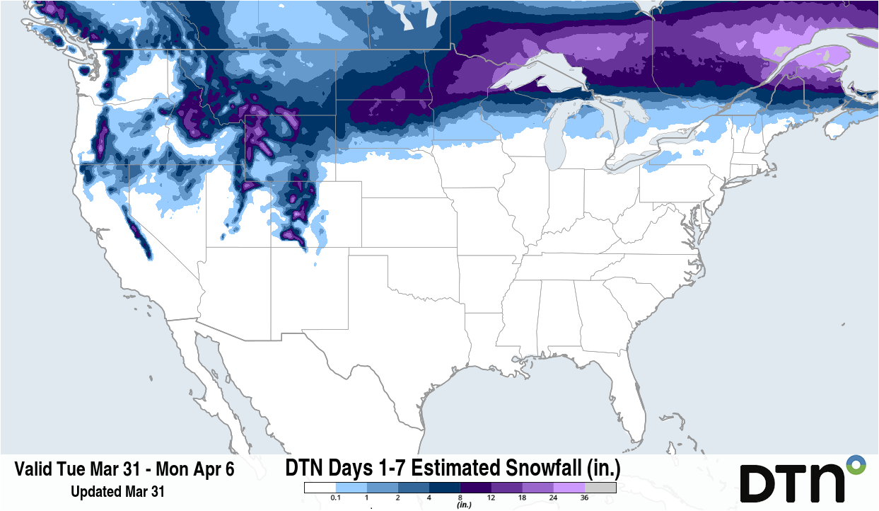
Image: Forecast accumulated snow between Monday, March 31 and Monday, April 6. Source: DTN.
Winds are forecast to be relatively calm during this event again as well, leading to lower issues for infrastructure, but coming at a bad time for travelers.
In the warmer part of the system, we should again find potential for severe weather. A band of strong-to-severe storms is forecast to develop from central Texas to Iowa on Friday. This severe weather threat will then spread from eastern Texas to Michigan and Ohio for Saturday.
As a sharp cold front pushes through the rest of the country on Sunday, it will be pulling down colder air from the northern US and Canada. Temperature changes will be quite significant; a drop of at least 20 degrees Fahrenheit is likely across southern zones. While not extremely cold by April standards, the sharp drop will be noticeable.
With so much going on, it is best to stay up-to-date with the latest forecasts in your area, as changes to primary impacts will certainly develop throughout the week.