
Severe storms hit northern NSW, southeast QLD
Intense thunderstorms are causing heavy rain in parts of northeast New South Wales and southeast Queensland on Friday, with Byron Bay copping 75 mm of rain in just one hour.
Slow-moving showers and thunderstorm associated with a coastal trough moved over the Northern Rivers district in NSW on Friday morning and early afternoon.
Some of the morning storms dumped hefty rain totals along the coast, with Ballina received 86 mm in the three hours up to 12:15pm AEDT.
Further north, rain gauges at Coopers Shoot and Belongil Creek near Byron Bay both registered more than 100 mm in three hours during the morning’s storms. The gauge at Belongil Creek also registered 75 mm in one hour.
This intense rain was enough to cause flash flooding in some areas, including Byron Bay. The Bureau of Meteorology issued a severe thunderstorm warning for heavy rainfall, which was still in place at 2:30pm AEDT.
Heavy showers and thunderstorms also spread into southeast Qld on Friday, with Upper Springbrook collecting 29 mm in one hour around lunchtime. A severe thunderstorm warning was also issued for parts of southeast Qld shortly after 1pm AEST.
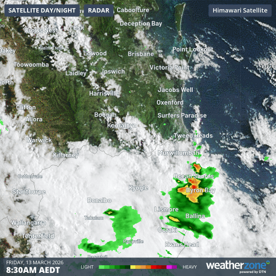
Image: Composite satellite and radar showing showers and thunderstorms moving over northeast NSW and southeast Qld on Friday, March 13, 2026. Source: Weatherzone.
The most intense rain and thunderstorm activity will focus on southeast Qld on Friday afternoon and night, allowing conditions to ease in northeast NSW.
Drier weather will return to southeast Qld and northeast NSW from the weekend as the rain and storms move further north with the low pressure trough.
Further severe thunderstorm warnings may be issued on Friday afternoon and night, so be sure to check the latest warnings in your area of the most up to date information.
Emergency services advise people to:
- Park your car undercover away from trees.
- Close doors and windows.
- Keep asthma medications close by. Storms and wind can trigger asthma attacks.
- Charge mobile phones and power banks in case the power goes out.
- Put your pets somewhere safe and make sure they can be identified in case they get lost.
- Do not drive now unless you have to because conditions are dangerous.
- Tell friends, family and neighbours in the area.
- Go inside a strong building now. Stay inside until the storm has passed.