
Seroja and Odette dancing dangerously close to Australia
Two tropical cyclones are entangled in a dangerous dance that will bring severe weather to parts of Western Australia from this weekend.
At 8am WST on Friday, Tropical Cyclone Seroja was a category one system located about 540km to the northwest of Exmouth, producing average wind speeds of 75km/h near its core. This is the same system that caused deadly flooding in Indonesia last weekend.
Meanwhile, a former tropical low to the northwest of Seroja strengthened into Tropical Cyclone Odette on Friday morning. At 8am WST, Odette was located about 1100 km northwest of Exmouth, which is roughly 500 km northwest of Seroja.
Odette is the seventh tropical cyclone to be named in the Australian region so far this season.
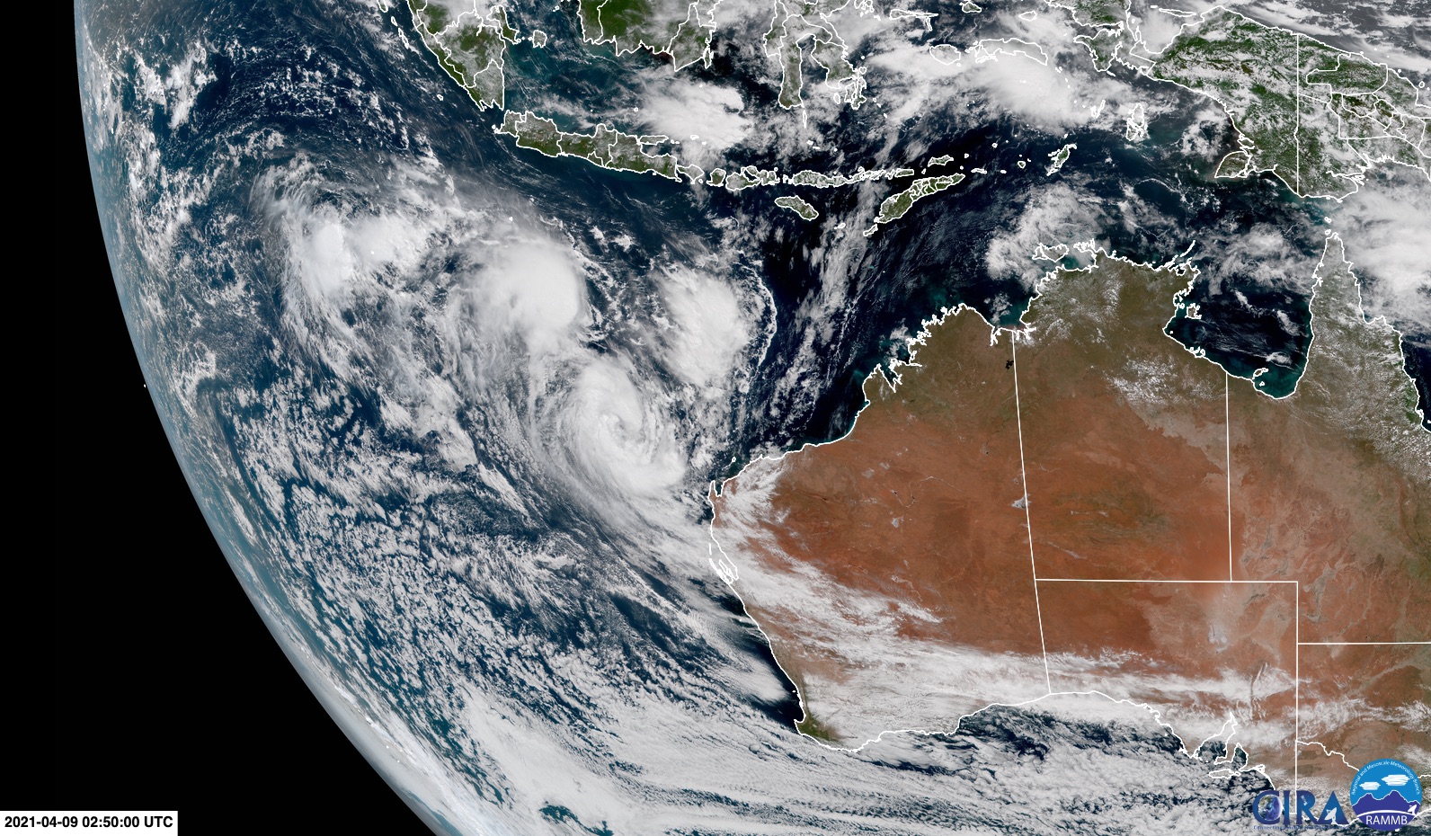
Image: Tropical Cyclones Seroja and Odette spinning in close proximity to the northwest of Australia on Friday. Source: RAMMB/CIRA
These two category one tropical cyclones are now influencing each other's movement, which has sent them into a rare and dangerous spin that could impact Western Australia.
Seroja and Odette are orbiting each other in a clockwise direction, which should cause Odette to swing around and pass close to the northwest corner of Western Australia on Saturday.
While Odette will be weakening as it swings past the state, it should pack enough energy to cause a brief period of rain and dangerous wind on Saturday. A severe weather warning has been issued for damaging winds between Exmouth and Coral Bay on Saturday afternoon and evening.
Following this brush with the remnants of Odette, Western Australia will be bracing for the arrival of Seroja.
The latest forecast models suggest that Tropical Cyclone Seroja should gain strength on the weekend, possibly become a category three severe tropical cyclone while still well offshore late Saturday or early Sunday.
The system is then expected to weaken a bit as it rapidly approaches the west coast of Western Australia on Sunday.
Based on current model guidance, Seroja could make landfall as a category one or two tropical cyclone somewhere between Carnarvon and Jurien Bay.
The Bureau of Meteorology points out that this is "an area not accustomed to tropical cyclones making impacts more significant".
Tropical Cyclone Seroja could cause damaging to destructive winds, heavy rain, flooding, large waves and abnormally high tides as it approaches and crosses the coast. Some of this severe weather may also extend inland after the system has crossed the coast.
There is still some uncertainty regarding the future development and movement of these two systems due to their close proximity and resulting influence on each other. Check the latest tropical cyclone advisories regularly for the most up-to-date information.