
Season's first super typhoon: Nando to batter Philippines, Taiwan, Hong Kong
Typhoon Nando (international name Ragasa) has undergone explosive strengthening over the Philippine Sea and is on track to become the season’s first super typhoon with significant impacts on land. The system is forecast to unleash destructive winds, torrential rain and life-threatening storm surges as it rages over northern Philippines and southern Taiwan early in the week, before continuing towards southern China and Hong Kong as a typhoon by midweek.

Image: Satellite loop of Nando from 7 a.m. to 10 a.m. on Sunday, 21 September 2025.
At 5 a.m. (Philippine time) on 21 September, PAGASA (Philippine Atmospheric, Geophysical and Astronomical Services Administration) reported that Nando’s eye was centred about 610 km east of Tuguegarao City, packing 10-minute sustained winds of 175 km/h and gusts up to 215 km/h. The storm was moving northwest at 15 km/h over very warm waters, an environment primed to fuel further intensification. Forecast tracks show Nando heading northwest through Sunday, then curving west-northwest towards the Luzon Strait. Its violent core may cross the Batanes group or skim just north of it late Monday, before exiting the Philippine Area of Responsibility early Tuesday.
PAGASA has warned that winds of 220–240 km/h are possible across northern Luzon, the Babuyan Islands, Batanes and southern Taiwan from late Monday into Wednesday.
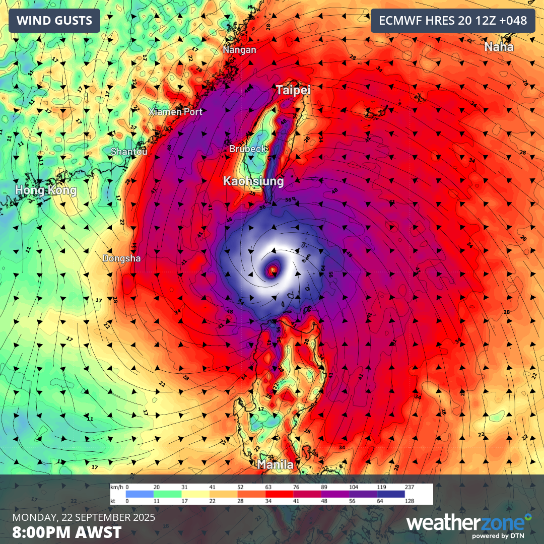
Image: Wind gust forecast from the ECMWF model for 8:00 p.m. Philippine Time on Monday, 22 September 2025, showing Typhoon Nando (international name Ragasa) bearing down on southern Taiwan and northern Philippines.
Rainfall totals of around 300 mm are likely, with localised deluges in excess of 700 mm set to trigger flash flooding and landslides. Life-threatening storm surges exceeding 3.0 m are expected to inundate low-lying coasts of Batanes, northern Cagayan and Ilocos within the next 48 hours, while seas of 8–11 m will make conditions perilous for all marine vessels.
Beyond the Philippines and Taiwan, Nando is projected to bring significant impacts to southern China, including coastal areas of Fujian, Guangdong and Guangxi provinces, as well as Hong Kong, from late Tuesday into Thursday. Rainfall of around 200 mm is expected along the southern China coast, leading to flooding and transport disruptions, while gale to storm force winds and dangerous storm surges will strike. Meteorologists warn the potential surge heights could rival those observed during Typhoon Hato (up to 2.42 m in 2017) and Typhoon Mangkhut (up to 3.40 m in 2018), both of which inflicted severe damage on the region.
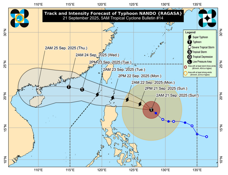
Image: Track and intensity forecast for Typhoon Nando (international name Ragasa) issued by PAGASA at 5 a.m. (Philippine time) on 21 September 2025, showing the system strengthening into a super typhoon as it nears the Batanes group and southern Taiwan, before heading westward towards southern China and Hong Kong by midweek.
Residents in the storm’s projected path — from northern Luzon to southern Taiwan and southern China, including Hong Kong — are urged to closely monitor official bulletins, prepare for destructive winds and flooding, and follow evacuation orders when issued.