
Rethinking the definition of a derecho
A powerful derecho tore across the Midwestern United States in June this year, causing widesperead damage and power outages in multiple states. Derechos like this have a long history in the United States but a recent study has proposed a new definition for these destructive windstorms.
During the evening of June 20 through the morning of June 21, 2025, a derecho raced across North Dakota and northern Minnesota. This system caused widespread damage, power outages and observed wind gusts up to 111 mph.
A derecho is a specific type of windstorm that has been getting more attention lately and with a recent study that was published in January 2025, there is now a modified definition for this type of storm.
Even with a modified definition, there are a few key factors that meteorologists examine to predict these destructive storms that are most common from May through August in the United States.
What does it take for a storm to be classified as a derecho?
The definition of a derecho may have more of an extensive history than you think. In 1888, Dr. Gustavus Hinrichs first proposed the term, derecho, when he was studying the impacts of windstorms that moved across the state of Iowa.
Some 99 years later, Robert Johns and William Hirt dove into a more extensive study that involved looking at 70 different derecho cases in the early 1980s. The study by Johns and Hirt proposed how to forecast these storms and defined a derecho as widespread severe windstorms that originate from a Mesoscale Convective System (MCS). An MCS, according to the American Meteorological Society, is a cloud system that occurs in connection with thunderstorms that produce a contiguous precipitation area that is 100 kilometers (62 miles) or greater in length in one direction.
Fast forward to January 2025, a study by Brian Squitieri, Andrew Wade, and Israel Jirak aimed to redefine what a derecho is. Their new definition states that a derecho is a widespread severe windstorm that’s characterized by groups of destructive downbursts that contain hurricane-force wind gusts derived from an extratropical, cold-pool-driven MCS.
For a non-meteorologist, this may seem like a loaded definition. To help break it down further:
- A downburst is a phenomenon associated with thunderstorms that can create damaging wind gusts due to cool, dense air within a thunderstorm accelerating towards the Earth’s surface.
- Hurricane-force wind gusts must be 74 mph or greater.
- Meteorologists use the term extratropical to reference a low-pressure system that has formed outside of the tropics.
- Lastly, a cold pool occurs when a region of relatively cold air accumulates at the surface, but it is surrounded by warmer air.
What causes a derecho?
Regardless of these definition changes over the years, meteorologists know some of the typical patterns and atmospheric ingredients that lead to derechos forming in the U.S. If there is an upper-air trough or area of lower pressure in the western U.S. with an upper-air ridge or an area of higher pressure in the eastern U.S., the area between the trough and ridge can be favorable for derecho formation.
There are two types of derechos that can form in this favorable region. A progressive derecho will typically form on the northern side of the upper-air ridge along a stationary front. The second type, a serial derecho, will form on the western side of the upper-air ridge and can be much larger in size than a progressive derecho, with multiple bowing segments within the storm.
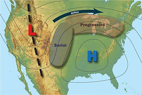
Image: The typical weather pattern setup for progressive and serial derechos to form across the United States. Source: NOAA / NWS
Meteorologists will also look at much more than just the large-scale weather pattern to decipher whether a derecho may form. It requires a range of correct ingredients occurring at the same time for these destructive storms to form.
A recent derecho that occurred in the U.S. happened on June 20-21, 2025. This derecho led to nearly 20 reports of tornadoes in North Dakota as it moved from west to east across the southern half of the state. Wind gusts in excess of 80 mph were reported along its path and some of the highest wind gusts approached 106-111 mph. In addition to the wind gusts and tornadoes, this derecho dropped 2-3-inch hail in some spots as well.
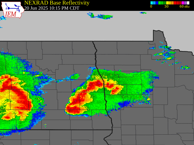
Image: Radar loop showing storms moving through North Dakota and northwest Minnesota that led to a derecho on June 20-21, 2025. Source: Iowa Environmental Mesonet.
Nearly 70% of all derechos in the U.S. occur during the months of May-August. There will likely be more of these destructive storms this summer, but oftentimes it’s difficult to pinpoint exactly where these derechos will form until hours before they hit. This is when a weather radar and official warnings can come in handy to stay up to date on where these storms could track.