
Renewal in large easterly swell for the NSW coastline
A deepening low pressure system off the northern NSW coast will bring a large easterly swell over the coming days, following a very active week of waves.
The NSW coastline has seen a very active period of waves over the last few weeks. In Sydney, the offshore waverider buoy has generally recorded significant wave heights around the 2-metre mark since Saturday 13th, with a brief spike to 3.7 metres on Monday 15th following a vigorous S/SE’ly wind, and some more mellow waves just below the 2-metre mark this weekend. These wave conditions have also been observed across the coast as this prolonged period of swell generation was provided by a broad fetch of E/SE’ly wind across the Tasman Sea as a significant pressure gradient remained very slow moving.
While wave heights may seem to be on the decline, a large pulse of easterly swell is on its way as a low pressure system deepens off the northern NSW coast, and moves southwards over the coming days. Wave height is expected to peak overnight in the 3-to-3.5 metre range across much of the Northern Rivers and Mid North coasts. While the peak may occur overnight, surf conditions will likely become hazardous on Sunday afternoon/evening and linger into Monday morning for areas including Byron Bay, Coffs Harbour and Port Macquarie. Further south, wave heights are expected to reach around 2.5 metres in Sydney on Monday and Tuesday.
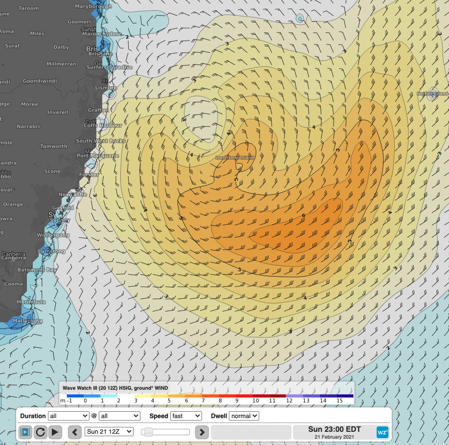
Wave Watch III model run showing Significant Wave Height and Wind with a large easterly swell directed to the entirety of the NSW coastline on Sunday, with waves likely to linger and continue to affect parts of the coastline over the first half of the coming week.
With the bulk of this swell event coming from the east, very few beaches will benefit from the usual headland protection offered from typical large south swell events. This will lead to generally hazardous surf conditions bringing elevated risks to beach goers, rock fishermen and boating enthusiasts. Hazardous Surf Warnings are currently in place for coasts between Byron and Hunter on Sunday, and extending further south to the Illawarra Coast on Monday. Cumulation of the previous week of sizable swell with this strong peak will also enhance beach erosion across usually protected coasts. To see the latest warnings for NSW, please visit: https://www.weatherzone.com.au/warnings.jsp?lt=wzstate&lc=nsw