
Record moisture levels over Brisbane
A weather balloon has uncovered record water vapour levels over Brisbane, as heavy rain pours over southeast Qld.
The balloon was released on Monday night, measuring the atmospheric pressure, temperature, humidity and wind speed at different heights in the atmosphere.
It found that the column above Brisbane airport contained 73.5mm of precipitable water, the highest amount since records began.
Update: An extra weather balloon was sent up this afternoon to sample the atmosphere ahead of expected severe weather. This showed 73.5mm of precipitable water, a new record for Brisbane Airport. Please stay up to date with warnings. Explainer: https://t.co/jyzPPMy6rW pic.twitter.com/6I1Cem7ejy
— Bureau of Meteorology, Queensland (@BOM_Qld) January 29, 2024
The precipitable water is the amount of water vapour in the atmosphere; the higher the value the more water there is available to be potentially rained out.
In Australia, heavy rainfall events have been associated with record-high precipitable water levels, which is why this is examined by meteorologists.
The record moisture levels in the southeast along with a deepening coastal trough have caused some heavy rain to fall in the past 24 hours in southeast Qld.
Dalby airport and St George, to the west of Brisbane both recorded their wettest January day in 20 years, with 73.2mm and 113.4mm respectively falling in the 24 hours leading up to 9am Tuesday, January 30.
Samford to the northwest of Brisbane recorded 123mm in one hour leading up to 2am on Tuesday and 296mm in 3 hours leading up to 3am on Tuesday. This rainfall led to flooding in the area and in Bray Park area.
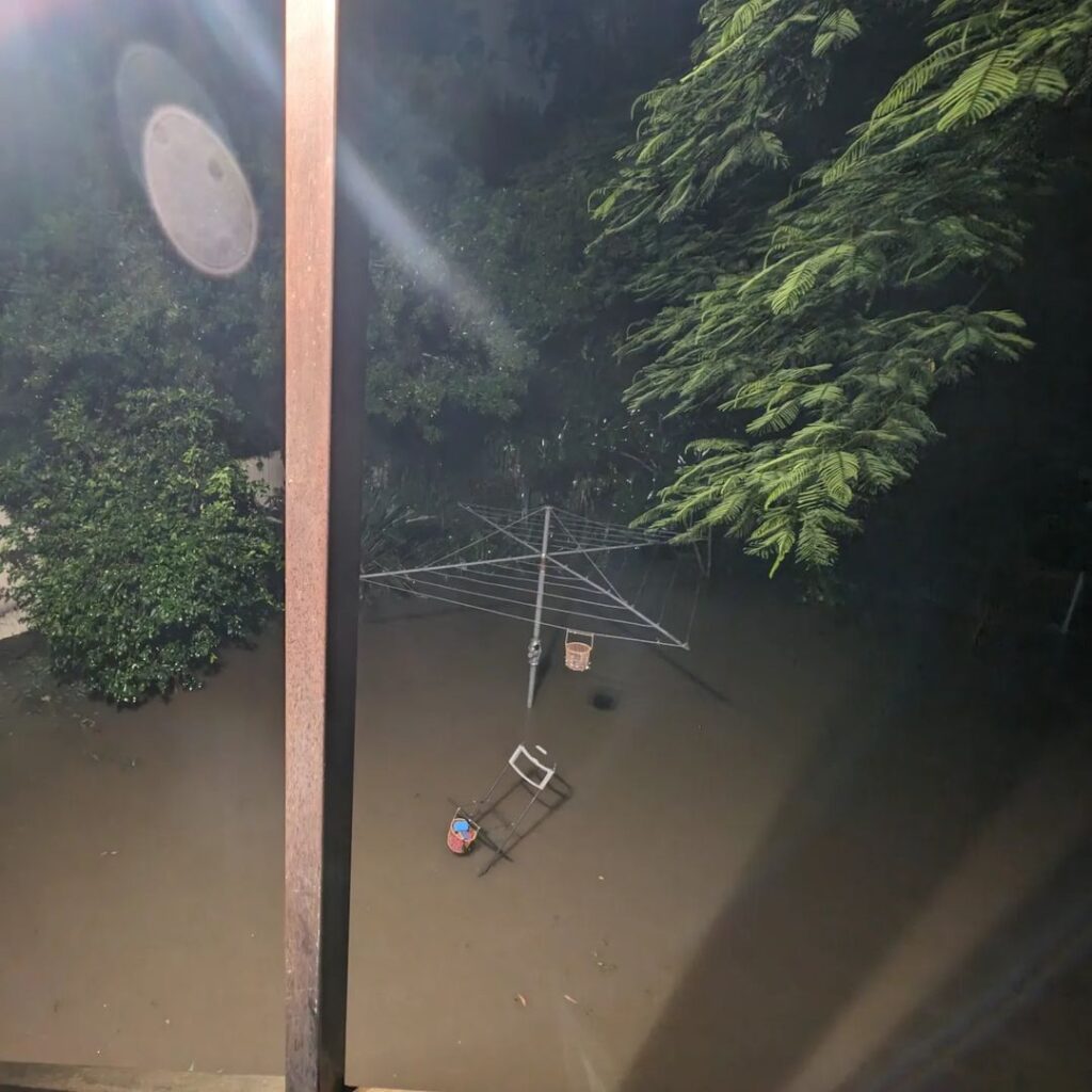
Image: Flooding in Bray Park captured at 2am early Tuesday morning, January 30, Source: @roaster_jase / Instagram.
The heavy rain, humidity and cloud cover also caused several high minimum temperature records to fall overnight:
- St Lawrence broke their all-time record (67-year history) with a minimum of 28.6°C.
- Yamba equalled the hottest January minimum temperature with the temperature failing to fall below 25.6°C, the previous record was set on Sunday night.
The satellite image below shows the rain and cloud continuing to impact southeast Qld on Tuesday morning, as a coastal trough deepens in the region.
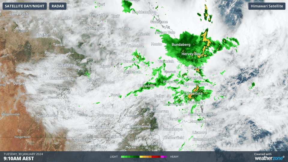
Image: Himawari-9 Satellite and radar on Tuesday morning, January 30.
This trough will bring heavy and intense rainfall, thunderstorms and the potential for flooding to the Wide Bay and Burnett, Darling Downs, Granite Belt and Southeast Coast forecast districts in the next 24 hours. A severe weather warning is current for this area on Tuesday morning.
The maps below show that forecast models are forecasting widespread falls of 100-200mm and isolated falls exceeding 250mm in the next 24 hours.
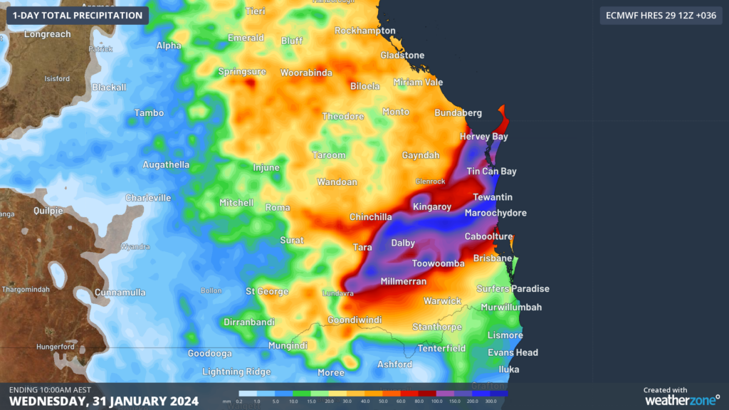
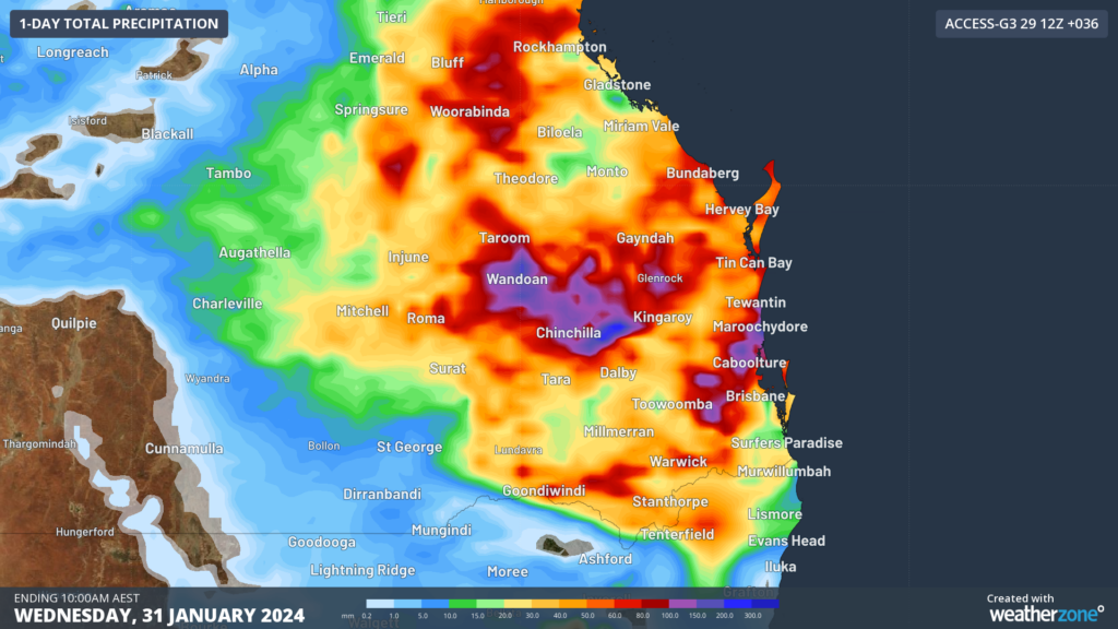
Image: 24- hour accumulated rainfall forecast to 10am AEST on Wednesday, January 31 according to ECMWF (top) and ACCESS-G bottom.
Some of this rainfall could fall in a short period of time, with six hourly rainfall rates of 80mm to 150mm likely, while totals could top 150mm to 200mm in thunderstorms.
A low-pressure system is expected to develop within this trough around Hervey Bay on Tuesday, increasing the rainfall in the region.
This system should move away from the Qld coast on Wednesday evening or Thursday morning easing the rainfall in the region.
Please stay updated with the latest warnings as this system evolves here.