
Record June heat gripping UK, more to come
The United Kingdom has set new maximum and minimum temperature records for June as an extreme heatwave intensifies over parts of Europe. With the heatwave likely to linger for another few days, more record-challenging temperatures are expected in the UK on Thursday and Friday.
Omega block causing extreme heat in the UK
A weather pattern known as an ‘omega block’ has allowed intense heat to build over Western Europe this week.
The term omega block refers to an upper-level weather pattern resembling the Greek letter omega (Ω), featuring a central high pressure system flanked by two areas of low pressure on either side.
These omega block patterns can cause domes of heat to build and intensify over a region for several days in a row. This week’s omega block has caused the UK and other nearby countries to experience heat at levels never before seen in modern weather records.
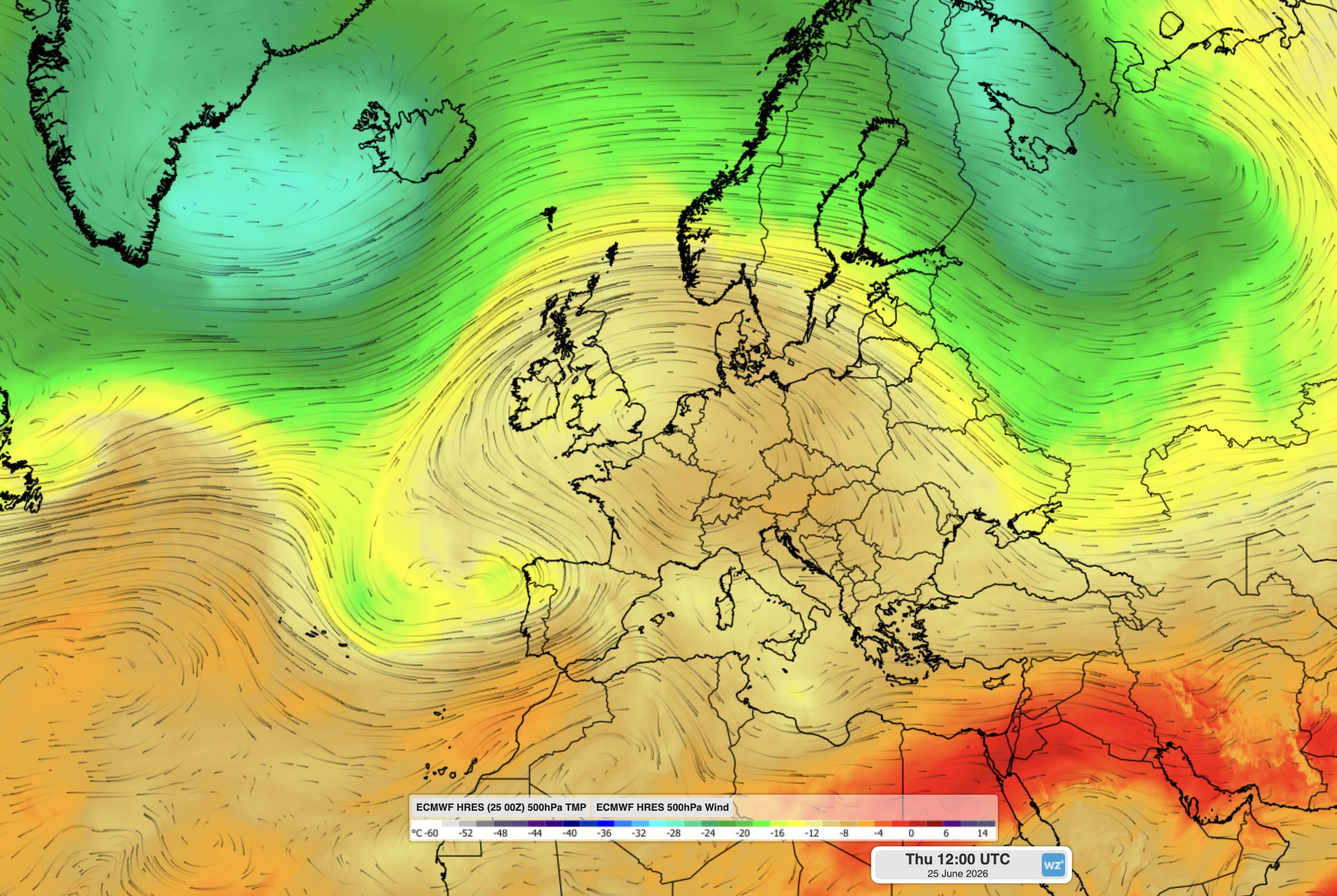
Image: 500 hPa temperature and wind showing an omega block over Europe on Thursday, June 27, 2026. Source: Weatherzone.
Heat records broken in the UK
On Wednesday, June 24, the temperature reached as high as 36.1°C at Gosport in Hampshire. This was the highest June temperature on record for the UK, beating the previous record of 35.6°C, which occurred on June 28, 1976 and June 29, 1957.
Wednesday’s intense daytime heat was followed by oppressive overnight warmth that also broke records in the UK.
A weather station at Bute Park, Cardiff registered a minimum temperature of 23.5°C on Wednesday night into Thursday morning. According to the Met Office, this was the highest June minimum temperature on record for Wales and the UK.
Another notable minimum temperature from Wednesday night was 23.0°C at Plymouth, which was a new June record for England.
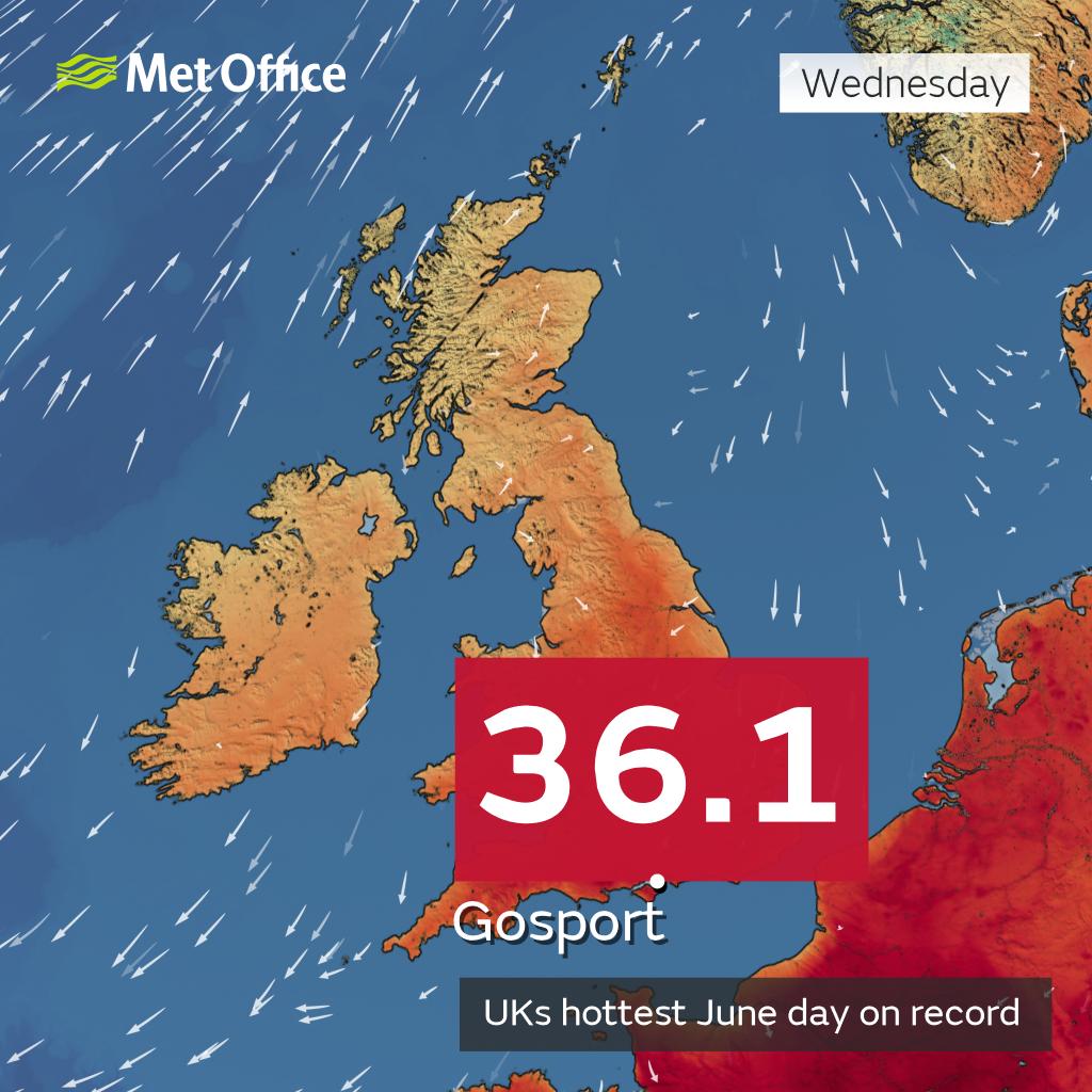
Image: According to the Met Office, Gosport’s 36.1°C on Wednesday, June 24, was a new June maximum temperature record for the UK. Source: Met Office.
These provisional records will be officially verified by the Met Office at the conclusion of this week’s heatwave.
More record-challenging heat ahead for the UK
Extreme heat and high humidity will continue to affect parts of the UK between Thursday and Saturday as the dome of heat lingers over the European region.
Red and Amber warnings have been issued for extreme heat, with temperatures expected to reach 36-37°C in some areas on Thursday and Friday. This means further records could fall before the end of the week.
Severe thunderstorms possible Thursday and Friday
In addition to this week’s heat, parts of the UK could see dangerous thunderstorms on Thursday and Friday as the atmosphere becomes unstable.
Some of these storms have potential to become severe, with heavy rain, gusty winds and lightning. Yellow warnings have been issued for thunderstorms in some areas on Thursday and Friday.
In Ireland, Northern Ireland and Scotland, thunderstorms which form on Thursday and Thursday night will bring the risk of large hail possibly reaching 2-4 cm diameter, strong winds, and very frequent lightning. The high moisture content of the airmass will also lead to the risk of torrential rain and flash flooding.
For South West England and South Wales, thunderstorms may move northwards from France through Thursday evening. These storms may produce severe wind gusts possibly reaching around 60mph.
Isolated thunderstorms could affect other parts of England and Wales overnight Thursday into Friday, although the nature of these storms will be hit and miss, so some locations will remain dry.
Relief on the way
Cooler and calmer weather will return to the UK by early next week as the dome of heat moves further east across Europe, allowing a westerly influence and more typical June temperatures to return to the UK.