
Rare rainfall double as Victoria drenched
Two unusual things happened overnight in Victoria.
Firstly, every one of the state's nine weather districts (or ten if you count the Melbourne metro region as a separate entity) received soaking rain in the 24 hours from 9 am Sunday to 9 am Monday.
That doesn't happen often. Depending on the type of weather system, you'll usually get rain in, say, East Gippsland but not the Mallee - or the other way around.
But to reference the old Tourism Victoria jigsaw puzzle ad, pretty much every piece of Victoria got some love from above from Sunday into Monday morning. As this table shows, 8 mm or more of rain was recorded by at least one weather station in each district.
The second remarkable rainfall stat from the 24 hours to Monday morning is that a Melbourne suburb was officially the wettest weather station in the state. This also happens infrequently.
Image: Melbourne is back on track for a November of close-to-average rainfall after a dry start to the month. Source: supplied.
Normally a mountain weather station will record heavier rain than Melbourne with a state-wide event like this, but Moorabbin Airport in Melbourne's southeast clocked in at 9 am with 63.2 mm in the gauge, which was the most of any Automatic Weather Station in the state.
For the record, it was also pretty much its entire November average rainfall (of 63.8 mm) in under a day.
Other Victorian locations to record high 24-hour rainfalls were Avalon (54 mm), Mt Baw Baw (60.2 mm) and Ballarat Airport (40.8 mm).
As the trough that brought the rain drifts eastwards across the state, attention now shifts to Gippsland and the North East, where the Bureau of Meteorology has issued warnings of heavy rainfall which may lead to flash flooding. Bairnsdale in east Gippsland received 20.6 mm of rain between 09 am and 11 am Monday.
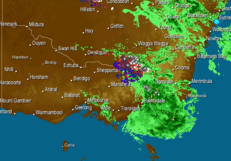
Meanwhile Canberrans also awoke to soggy lawns and wet roads on Monday morning. That is, if they got any sleep.
Extremely loud thunderstorms ripped through the capital around 1 am overnight, dumping 30 mm of rain in most suburbs, with 50.6 mm in the gauge at Mt Ginini in the Brindabellas - at 1760m above sea level, remote Mt Ginini is the ACT's highest Automatic Weather Station and the fourth-highest in the country.
Warmer, drier conditions look likely to return to most of southeast Australia as the week progresses, with hot weather on the cards for the weekend.