
Rainfall exceeds 100mm where three states meet
Extremely heavy rain has fallen in the region around Cameron Corner, the location where the borders of Queensland, New South Wales and South Australia intersect. Parts of the Northern Territory well south of the tropics also saw some very heavy rainfall totals.
Notable rainfall totals in the 24 hours to 9am Tuesday included:
- 120.6mm at Winnathee, a weather station in the far northwest corner of NSW
- 106.6mm at The Garden, a weather station located just northeast of Alice Springs in the NT
- 85mm at Bellalie in the Quilpie Shire in the far southwest corner of Qld
- 43.6mm at Tibooburra Airport in far northwest NSW, which brought the February total to 123.4mm - more than half the average annual rainfall of 215.1mm in the town of approximately 100 residents
- 36mm at Moomba in South Australia
What caused such heavy outback rain?
A slow-moving low pressure system and associated trough has been interacting with a constant feed of tropical moisture from the north.
Tropical low centred over the Simpson Desert on Tuesday morning. pic.twitter.com/9PpqKUQwYv
— Andrew Miskelly (@andrewmiskelly) February 24, 2026
This system will continue to cause heavy rain and thunderstorms over parts of central Australia every day this week, as the low pressure system remains in roughly the same spot for most of the week.
This is very unusual.
As Weatherzone meteorologist Ben Domensino explained on Monday, mid-latitude low pressure systems typically impact an area for only a day or two before weakening or moving away.
But as mentioned, outback areas can expect more rain this week. Wet and stormy weather will also extend towards southern and southeastern Australia at times.
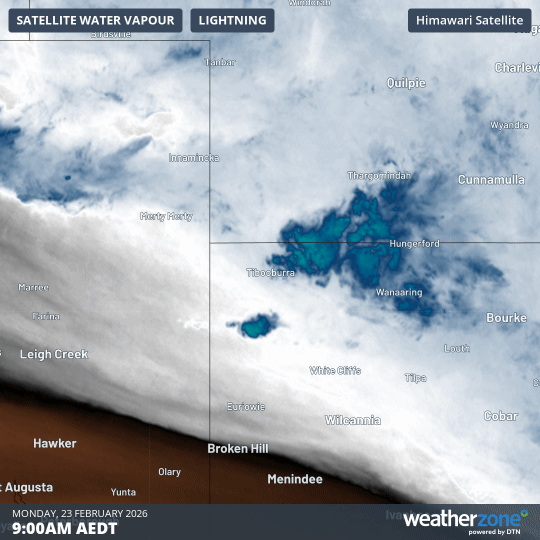
Image: 12-hour loop showing water vapour over the interior of the eastern half of Australia from 9am to 9pm (AEDT) on Monday, February 23, 2026.
You can see the rain and storms developing in the 12-hour loop above from 9am to 9pm on Monday.
What does the water vapour layer show?
As Weatherzone meteorologist Joel Pippard explains, water vapour satellite imagery tracks specific infrared radiation wavelengths that water vapour strongly emits, then converts that into a false colour image.
"The more intense colours correlate with higher layers of moisture, and generally higher concentrations of water vapour," Pippard explains.
"Areas shown in brown indicate that the moisture layer is very low, suggesting drier conditions higher up in the atmosphere."