
Rainband teases Adelaide, dampens other parched areas
The main body of a rainband crossing southeastern Australia has slid agonisingly south of Adelaide, providing only the barest rain relief of 0.6mm relief for the parched SA capital's main West Terrace/ngayirdapira weather station.
- To date in 2026, Adelaide has now received just 3.4mm of rainfall. That rain has fellen on two separate rain days in February.
- January 2026 was totally dry in Adelaide.
- Just 2.8mm was recorded in December 2025, meaning the 2025/26 summer has thus far yielded a paltry 6.2mm of rain, as of 3pm on Tuesday (ACDT).
- Adelaide's driest summer on record was 1905-06 with just 4.0mm, when 1.7mm in December was followed by a dry January and 2.3mm in Feb.
So this summer will not go down in history as Adelaide’s least rainy on record, but it has still been desperately dry. And that’s what makes this Tuesday’s rainband so frustrating for locals.
Anything more than a few drops of rain would have been particularly welcome to Adelaideans after Monday's maximum of 37.3°C and an uncomfortable night afterwards, with the mercury bouncing above 30°C at 1am.
Some suburbs did get a decent drop in storms that passed through about an hour after the main rainband slipped southeast.
Auldana (Seaview) on the eastern fringe of the city at the foot of the Adelaide Hills received 10.8mm within just 15 minutes, while some areas immediately north of the CBD also saw 10-15mm in brief but intense downpours.
However most suburbs saw less than a millimetre of rain, while others received none at all.
If not Adelaide, which areas could see rain today?
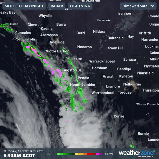
Image: Combined 4-hour radar and satellite loop for SE Australia early on the morning of Tuesday, February 17, 2026.
As you can see on the loop above, parts of southeastern SA and southwestern Vic have saw rain earlier this Tuesday, as the rainband associated with a trough and weak cold front marched east.
Southern Victoria can expect further showers throughout this afternoon, with the cool change and showers reaching Melbourne later today after hot maximums in the mid-to-high 30s across the metropolitan area.
- In the 24 hours to 9am Tuesday, the highest SA rainfall reading was 13mm at Kingscote on Kangaroo Island, where just 1.4mm had fallen previously in 2026.
- On the mainland, the highest reading was 11.6mm at Willunga, about 45 km south of the Adelaide CBD. The town of 3600 had received just 3.6mm previously this summer.
- Between 9am and 11am (ACDT), falls of a few millimetres were recorded in numerous locations in the state’s southeast, as well as in western Victoria.
Heavier falls are still possible in some SA locations this Tuesday due to the relatively well-organised band of storms crossing the Murraylands and Upper South East forecast districts.
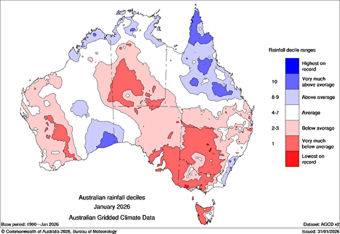
Image: Rainfall deciles across Australia in January 2026, showing how dry the month was in areas that could see some rain this Tuesday, February 17. Source: BoM.
By early afternoon, the rain and storms should have cleared South Australia. Then it will be Victoria’s turn.
As in SA, rainfall accumulations in Victoria should only amount to a few millimetres at most places, however moderate totals of 10mm or more are possible as afternoon storms whip through.
The rain focus will shift to Tasmania later today, with statewide falls likely, heaviest in the west.