
Rain to the left of me, storms to the right, here we are stuck in the middle…
A trough developed across central NSW and Queensland later on Friday, fueled by an upper pool of cool air. This set off widespread showers and isolated heavy falls across central and south-west Queensland. As the trough edged east overnight, low-level south-easterly winds pumped in extra moisture, further boosting rainfall totals.
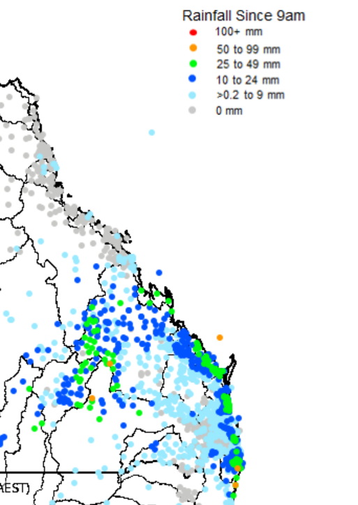
BoM rainfall to 9am on 09/08/2025
In the 24 hours to 9am Saturday, Sandstone Park (central Queensland) recorded 61 mm, while Tyrconnel (south-west Queensland) picked up 59 mm, with most of the region seeing 25–40 mm. In summer, these amounts wouldn’t raise eyebrows, but in August (typically the driest month with Tyrconnel averaging just 22.5 mm) they’re certainly noteworthy.
Meanwhile, along the coast, a separate trough and embedded meso-low brought heavy showers and isolated thunderstorms to the central and southern Queensland coast. Coastal 24-hour totals were generally 30–40 mm.
The coastal trough is moving offshore today, so eastern Queensland can expect gradual improvement if you’re looking for drier conditions. That said, persistent onshore winds will keep coastal showers in play for the rest of the day.
If you are planning on heading to the Ekka at Brisbane's showground today- dont't forget to pack your brolly. Fewer showers expected on Sunday and Monday with a better chance of staying dry.