
Rain, storms and strong winds sweep southern Australia
Steady rain is soaking parched parts of South Australia this Tuesday, with moisture making its way towards Victoria as a complex low pressure system crosses the south of the continent ahead of a cold front.
The loop below shows a rainband tracking in a southeasterly direction across SA on Tuesday morning, generating showers as far north as SA’s North West Pastoral forecast, as far east as the Riverland and Murraylands, and as far south as Adelaide.
The Eyre and Yorke peninsulas are also receiving welcome rainfall, while the state’s wettest corner (the southeast) can expect rainfall from this afternoon onwards.
Image: Three-hour combined satellite and rainfall loop to 9:30am (ACST) on Tuesday, October 21, 2025.
Storms are accompanying the rain at times, as can be seen on the loop above, where pink blobs correspond to areas of lightning activity.
Potentially damaging winds are also likely at times, and numerous wind warnings are in place for coastal parts of SA and Vic for Tuesday and Wednesday – including a severe weather warning issued at 10:39am (ACST) this Tuesday for damaging, locally destructive winds across the southeast.
This rain will be very welcome in both South Australia and in Victoria.
Rainfall totals of around 10-15mm were recorded at multiple locations in SA's Mount Lofty Ranges in the 24 hours to 9am Tuesday, and while these weren’t huge totals, they were the heaviest since winter in what has been a relatively dry spring to date.
Adelaide itself has also had a dry time of late. After the SA capital saw its wettest July in 27 years, the city has endured three months with only around half its average rainfall.
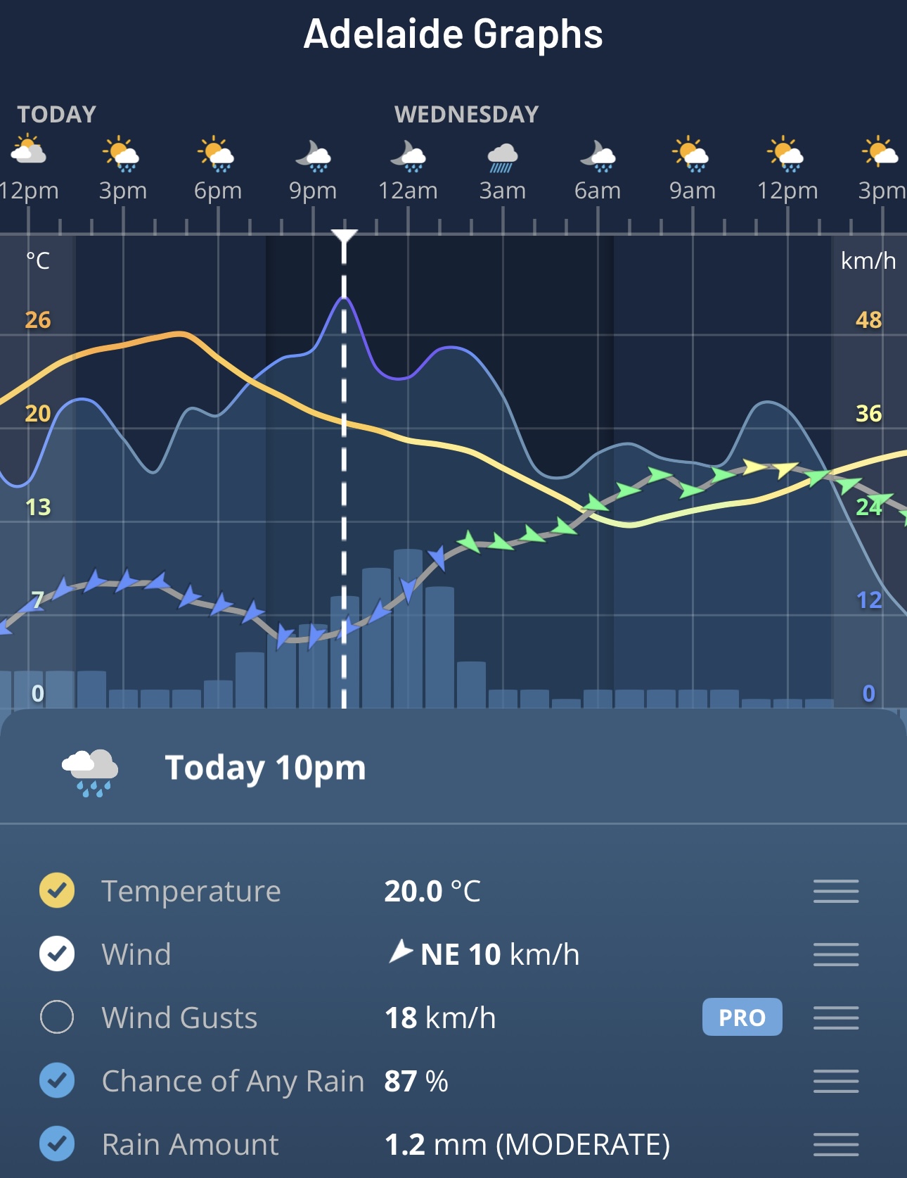
Image: Wind and rain data for Adelaide on Tuesday evening into Wednesday on the Weatherzone app.
While a moderate total of 4mm was recorded overnight, that was the first rain in two weeks and the good news is that moisture continues to stream Adelaide's way. A further 3mm was received between 9am and 11am local time, with a healthy total in the 10-20mm range forecast for today.
Melbourne is another southern capital that has missed out on much of its usual spring rainfall to date, with below-average rainfall totals for each month from July onwards, including the running total for this month as of October 21.
Unfortunately, only relatively light totals of up to 5mm are expected today or tomorrow for Melbourne but western Victoria should see some handy falls.
For example, Horsham in the Wimmera has seen only about a third of its average rainfall in September and the first three weeks of October, but it should receive 5-10mm from the current system.
Some locations could see much heavier falls in downpours during thunderstorms.