
Rain remains elusive for parts of Australia despite expectations of a wet spring
Many Australians that were hoping for a wetter than average spring have been left disappointed by a lacklustre start to the season, despite the emergence of a strong negative Indian Ocean Dipole in recent weeks.
Official rainfall outlooks at the end of August were pointing to a good chance of above average spring rainfall for most of the eastern two-thirds of Australia. This outlook was underpinned by signs of a developing negative Indian Ocean Dipole (IOD), a climate driver that usually boosts spring rainfall over much of the country.
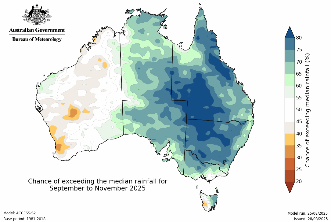
Image: Spring rainfall outlook issued by the Bureau of Meteorology at the end of August 2025. Source: Bureau of Meteorology
The prospect of a wet spring was particularly welcome news for farmers in southern and southeastern Australia that have suffered from severe rainfall deficiencies in recent months and years. This hope was justified, with history showing that these parts of the country typically see decent spring rainfall under the influence of a negative IOD.
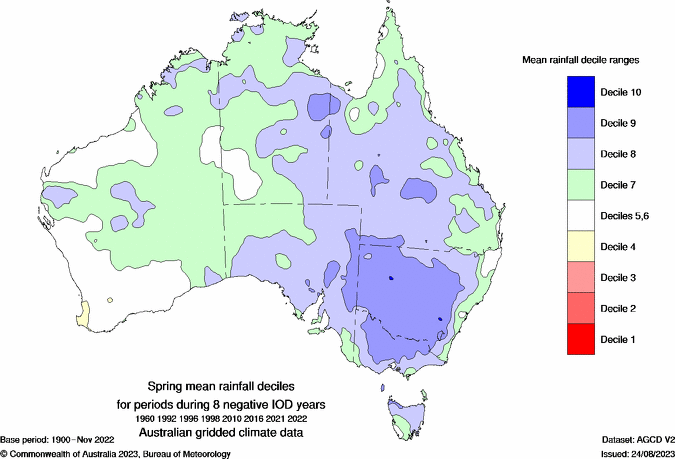
Image: Average spring rainfall deciles observed during 8 negative IOD events between 1960 and 2022. Green and blue shading shows where spring rainfall is usually above average during a negative IOD event. Source: Bureau of Meteorology.
Negative IOD has emerged
As expected, the IOD has entered a strong negative phase in recent weeks, with the IOD index dropping to -1.49°C in the week ending on October 5, 2025. This is the lowest weekly IOD value in more than 20 years according to data on the Bureau of Meteorology’s website.
Unfortunately, despite the anticipated development of a strong negative IOD, rainfall hasn’t been as heavy or widespread as expected in the opening weeks of spring. September was abnormally dry for large areas of southern and eastern Australia and much of the country has been dry in the opening week of October.
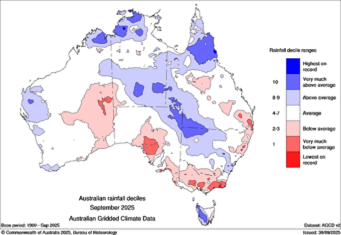
Image: Rainfall deciles during September 2025. The red areas show where rainfall was below average, and the blue areas show where rain was above average. Source: Bureau of Meteorology.
Other factors at play
Negative IOD events usually boost rainfall over Australia by increasing the frequency and strength of northwest cloudbands, which are vast bands of cloud that cause rain to spread across the country from the northwest towards the southeast.
This spring, however, these northwest cloudbands have had little impact on Australian rainfall.
One reason for this has been the atmosphere responding to a rare episode of stratospheric warming above Antarctica in September and early October. This phenomenon, which is extremely difficult to predict ahead of time, has altered weather patterns across the Southern Hemisphere and counteracted the influence of the negative IOD over Australia in recent weeks.
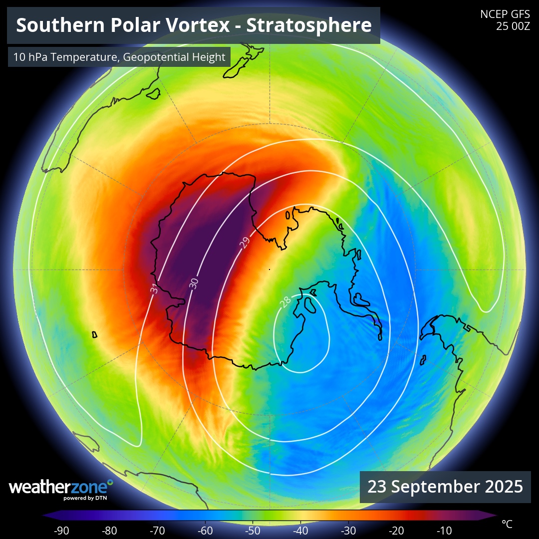
Image: Abnormally warm air in the stratosphere above Antarctica in late September 2025.
The influence of this season’s stratospheric warming over Antarctica has seen rainfall continuing to elude some parched areas of southern and southeastern Australia in recent weeks. It has also kept eastern Australia relatively dry and warm for this time of year, leading to outbreaks of early-season fires in parts of Qld and NSW.
Looking ahead, the IOD is expected to remain in a negative phase for the rest of spring before returning to a neutral phase in early summer. While this negative IOD may continue to be counteracted by the influence of the recent polar stratospheric warming event through the middle of October, there are signs that the IOD will have more or a typical influence on Australia's weather by November.
This season has been a good reminder that seasonal forecasts should be used more as a guide than a definitive forecast. Climate drivers like the IOD and La Niña often have a predictable influence on Australia’s weather, but there are other factors at play that can counteract the influence of these climate drives in any given season. Staying up to date with the latest monthly updates and daily forecasts throughout the season is the best way to stay ahead of any upcoming weather.