
Rain records obliterated in WA Kimberley region
Heavy rain is falling in Western Australia's Kimberley region, with numerous records broken for this time of year, in a part of the country which typically gets almost no rainfall in September, as we told you in this story on Monday, .
September is normally the driest month of the year in the region, with an average monthly rainfall of just 1.0 mm in the town of Derby (population 3300), about two-and-a-half hours northeast of Broome on the Kimberley coast.
But we told you in that Monday story that unseasonable rain could be heading that way, and so it has proven with some pretty amazing falls for this time of year.
- To 9 am this morning, Derby received 28.6 mm.
- By 1 pm today local time, another 35 mm had fallen, which really is exceptional for this time of year.
- Derby Post Office has officially had its heaviest September rainfall in over 100 years of records.
- Even higher totals were recorded at the nearby weather station at the Curtin RAAF base, with 33.2 mm to 9 am and 41.6 mm to 1 pm at a location that on average sees just 0.1 mm in September (as in, virtually nothing).
- The 33.2 mm to 9 am Friday morning was easily the highest September rainfall on record for Curtin. Indeed the previous record was just 1.8 mm!
Like virtually all of northern Australia, the Kimberley region does indeed have a wet season, but it doesn't usually kick in until late November, running through midsummer till early spring.
So what's happening?
A persistent area of low pressure over WA is drawing tropical moisture over central Australia. This will fuel widespread showers and thunderstorms during the first week of October. pic.twitter.com/QUtZMXTMWz
— Andrew Miskelly (@andrewmiskelly) September 30, 2022
As Weatherzone meteorologist James Rout explains, a cut-off low over WA is drawing deep tropical moisture to fuel storms in the area. The moisture has been enhanced by warmer-than-normal water off Australia's northwest coast.
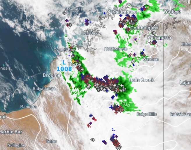
You can see the rain in the Derby area on the radar image above, taken at 12:50 pm local time. You can also see the low pressure system just near Derby, as well as numerous storms extending well inland – the silver crosses are lightning flashes.
The showers and storms are likely to continue into Saturday across the region, with more in store for some areas on Sunday too, before things ease off on Monday, when the end of the dry season will feel like the end of the dry season again – give or take the puddles.