
Rain for every Australian state and territory this week
A dynamic weather pattern will cause rain and thunderstorms over large areas of eastern, southern and western Australia this week. This wet weather will affect part of every state and territory, with heavy falls and flooding possible in at least two states – most likely New South Wales and Tasmania.
This week’s active weather pattern will be driven by a series of slow-moving upper-level troughs and low pressure systems. These are essentially pools of cold upper-level air that cause the atmosphere to become unstable, creating an ideal environment for the development of wet, stormy and windy weather.
Week-long soaking for southeastern Australia
Arguably the most noteworthy synoptic feature that will affect Australia this week will be a series of slow-moving cut-off upper-level low pressure systems that will sit over or near southeastern Australia for the next 8 days.
This slow-moving sequence of upper-level lows will cause rain over parts of SA, Qld, NSW, Victoria, Tasmania, the ACT and the southern NT from Monday to Wednesday. The bulk of the rain is then expected to contract towards eastern Australia on Thursday and Friday, before further showers spread over southeastern Australia over the weekend.
The map below shows how much rain one computer model is predicting over southeastern Australia this week.
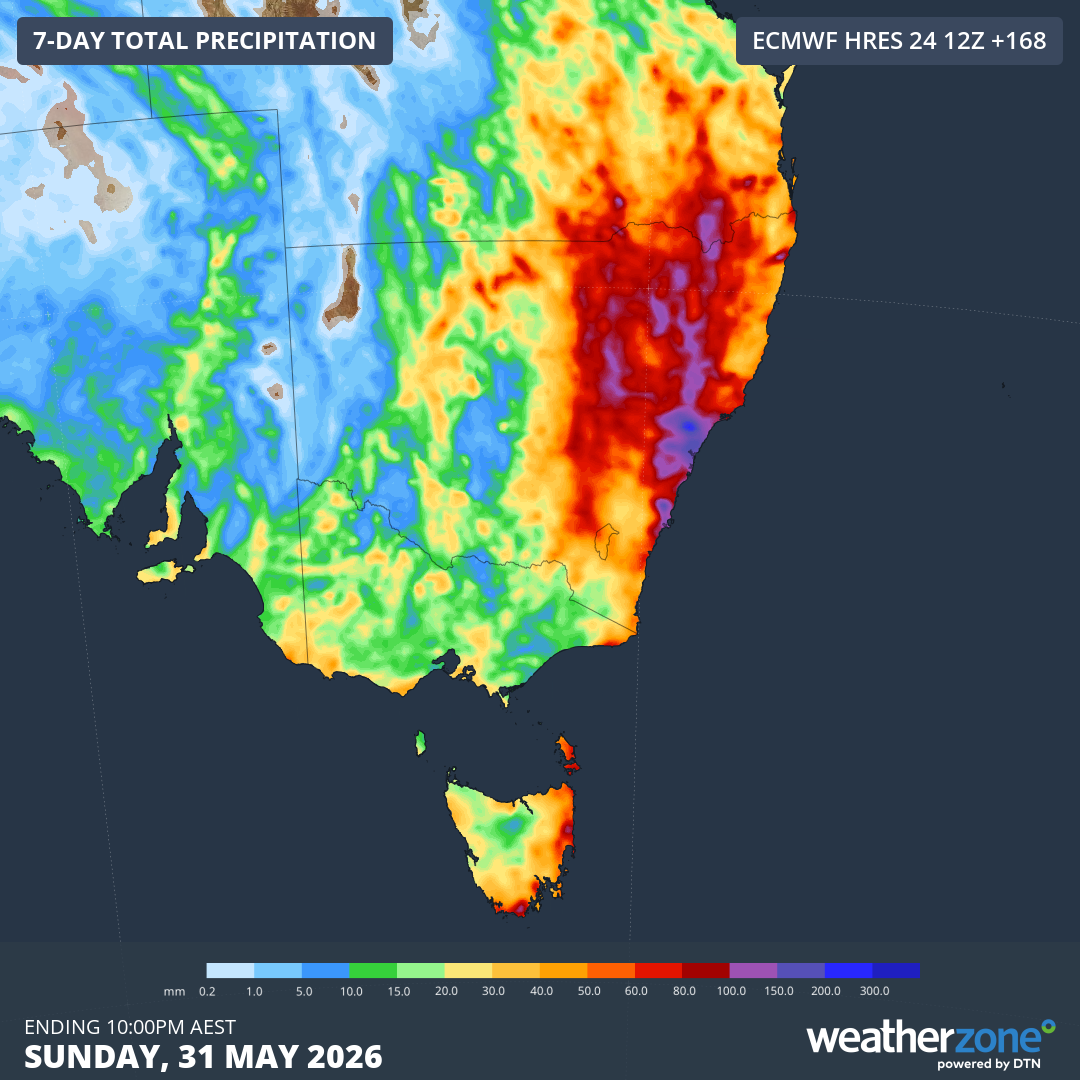
Image: Forecast accumulated rain over southeastern Australia during the seven days ending at 10 pm AEST on Sunday, May 31, 2026. Source: Weatherzone.
It’s currently difficult to predict exactly where and how much rain will fall over the coming week due to the dynamic nature of how the upper-level lows will interact with each other. At this stage, eastern and northern NSW and eastern Tas are two areas that have a good chance of seeing heavy rain and flooding this week. Parts of the ACT, eastern Vic and southern Qld also have a risk of heavy falls.
In addition to the rain, eastern areas of NSW, Vic and Tas are likely to see an increase in wind and waves towards the end of the week as a surface-based low pressure system develops over the Tasman Sea.
Wind, rain and storms coming for Western Australia
Two noteworthy systems will impact WA this week. The first will be a cold front that will deliver a burst of rain, thunderstorms and blustery winds to the state’s southwest on Wednesday and Thursday. This will be a typical winter-style cold front, the type most locals will be accustomed to experiencing at this time of year.
Later in the week, a complex low pressure system could bring another intense round of rain, thunderstorms and blustery winds to the southwest of WA from Saturday to Monday. This system could cause heavy rain, damaging winds and severe thunderstorms.
The map below shows this week’s forecast accumulated rain over southwestern Australia.
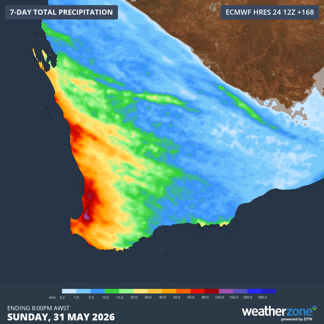
Image: Forecast accumulated rain over southwestern Australia during the seven days ending at 10 pm AEST on Sunday, May 31, 2026. Source: Weatherzone.
Severe weather is possible in multiple Australian states and territories this week. Check the latest forecasts and warnings in your area for the most up-to-date information throughout the week.
If you need emergency assistance due to this week’s weather, contact the SES on 132 500. In life-threatening emergencies, call triple zero.