
Rain clearing NSW, Vic as complex low engulfs Tasman Sea
The system that brought destructive weather to NSW and heavy rain in Vic over the last few days is finally moving away from Australia, forming a colossal low pressure complex that covers most of the Tasman Sea.
The satellite images below show a large multi-centred low pressure complex covering much of the Tasman Sea on Thursday. The clouds being driven towards eastern Victoria and the thick cloud covering New Zealand are all being influenced by the broad area of low pressure spanning the Tasman.
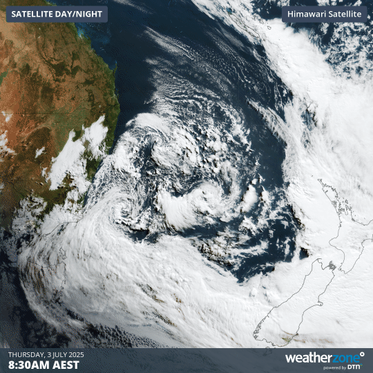
Image: Visible satellite images captured during the four hours ending at 12:30pm AEST on Thursday, July 3, 2025.
This broad region of low pressure is made of up multiple individual low pressure centres, including the one that produced destructive winds, flooding rain and damaging surf in NSW earlier in the week.
Some of the notable falls from the 24 hours to 9am AEST on Thursday included:
Victoria
- Multiple readings between 50mm and 95mm in Victoria's East Gippsland and West and South Gippsland forecast districts.
- 95 mm at Mt Wellington, a 1634m peak not to be confused with the 1271m kunanyi/Mt Wellington above Hobart in Tasmania.
- 15mm in Melbourne.
New South Wales
- 64mm at Jervis Bay, taking their three-day total to 331mm
- 67mm at Point Perpendicular, the third straight day of totals between 66mm and 80mm at that dramatic cliffside location on the northern tip of the entrance to Jervis Bay.
- A further 44 mm at Ulladulla, bringing that South Coast town’s total for the first three days of July to 308 mm. The long-term July monthly average is 87.2mm. https://www.weatherzone.com.au/station/SITE/69138/daily-summaries
With the low now moving away from southeastern Australia, rain is clearing, and wind and swell will continue to ease over the coming days.