
Queensland skies alive with lightning from outback to coast
Central parts of Queensland, from the Northern Territory border to the coastline, are experiencing a late afternoon sky show this Thursday, with storms and lightning strikes stretching across the state.
At 3:48pm (AEST), the BoM issued a severe thunderstorm warning for heavy rainfall for parts of the Central Coast and Whitsundays, Central Highlands and Coalfields, and Capricornia Forecast Districts.
The BoM warned that slow-moving thunderstorms could produce heavy rainfall that may lead to flash flooding in the warning area over the next several hours. Locations which may be affected include Moranbah, Eungella and Nebo.
While the most severe late afternoon storms appear to be in eastern parts of the state, storms have been highly active out west too during Thursday.
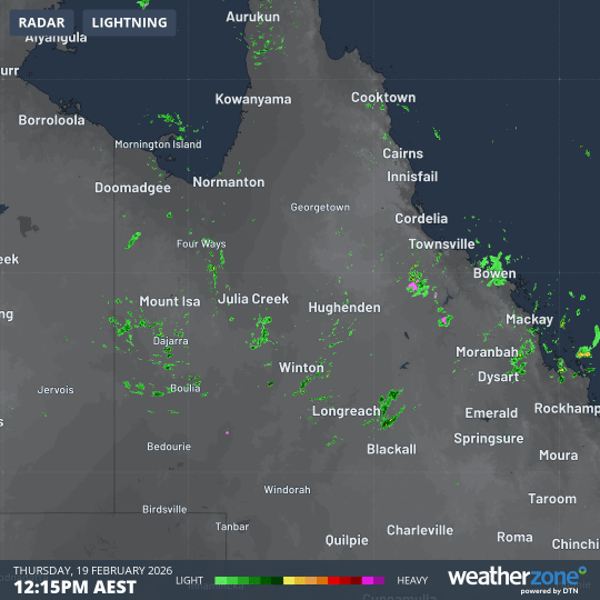
Image: Four-hour radar loop in central Qld on the afternoon of Thursday, February 19, 2026.
You can see the storms developing in the radar loop above, which shows the period from 12:15pm to 4:15pm (AEST). The pink blobs indicate areas where lightning is present.
One feature which is clearly visible on the radar loop is the storm that dumped 34mm of rain on Boulia, a tiny far western Qld town of 300 people about halfway between Mt Isa and Birdsville.
That was more rain in a few hours than the town’s entire monthly average for February of 27.2mm.
What’s causing the widespread storms?
A persistent, near-stationary trough over central Queensland and the eastern NT is causing moist, warm air to rise into a relatively unstable layer of air, producing storms.
While moisture is being provided by a consistent if relatively languid feed of tropical air from the east, the moist landscape is also playing its part, having been saturated in recent weeks.
The image below shows rainfall totals across Australia over the past week.
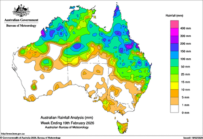
Image: Weekly rainfall totals for Australia for the week ending 9am this Thursday, February 19. Source: BoM.
As you can see, most of Queensland has had a good recent soaking, including all of the areas where storms are forming this Thursday.
Stormy days are set to persist into Friday and the weekend for much of Queensland.