
Queensland flood risk as heavy tropical rain spreads south
Heavy rain has inundated parts of northern Queensland over the last two days, and the state’s southeast could be next in line for heavy falls over the weekend. However, there is a high amount of uncertainty about how much rain will hit southeast Qld over the weekend, which makes it difficult to predict the likelihood of flooding.
Heavy rain in northern Qld
A tropical low has caused intense rainfall over Qld’s North Tropical Coast on Thursday. Some rain gauges in the Daintree region received 300 to 400 mm of rain in the 24 hours to 9am on Friday, including more than 200 mm in six hours.
A rain gauge at Bairds received 240 mm in six hours on Thursday night. Unsurprisingly, the Daintree River level at Bairds rose rapidly in response to this deluge, going from 3.7 metres at 11am AEST on Thursday to 13.9 metres at 11pm, an increase of more than 10 metres in 12 hours. Thursday night’s river level at Bairds exceeded the major flood height by close to 2 metres.
While rain had eased over northern Qld on Friday morning, the tropical low could continue to cause areas of heavy rain into Friday night as it moves over land from the Coral Sea. At 2pm AEST on Friday, a severe weather warning was in place for heavy rainfall in parts of the Peninsula, Gulf Country, North Tropical Coast and Tablelands, Northern Goldfields and Upper Flinders and Herbert and Lower Burdekin Forecast Districts.
Rain risk spreading south this weekend
The surge of tropical moisture that has fuelled heavy rain in northern Qld over the last 24 hours is expected to spread further south this weekend, feeding into a low pressure trough and the remnants of the tropical low. However, there is currently a high amount of uncertainty regarding how far south the rain will spread, and how much will fall.
Some computer models predict that moderate to heavy rain will spread over a broad area of central and southern Qld between now and Monday, with potential for more than 200 mm of accumulated rain in southeast Qld. Other models disagree on the intensity of the rain for the state’s southeast, instead keeping the heavier falls further north over central Qld.
The two maps below show the forecast accumulated rain over the next seven days, highlighting the model disagreement for the state’s southeast.
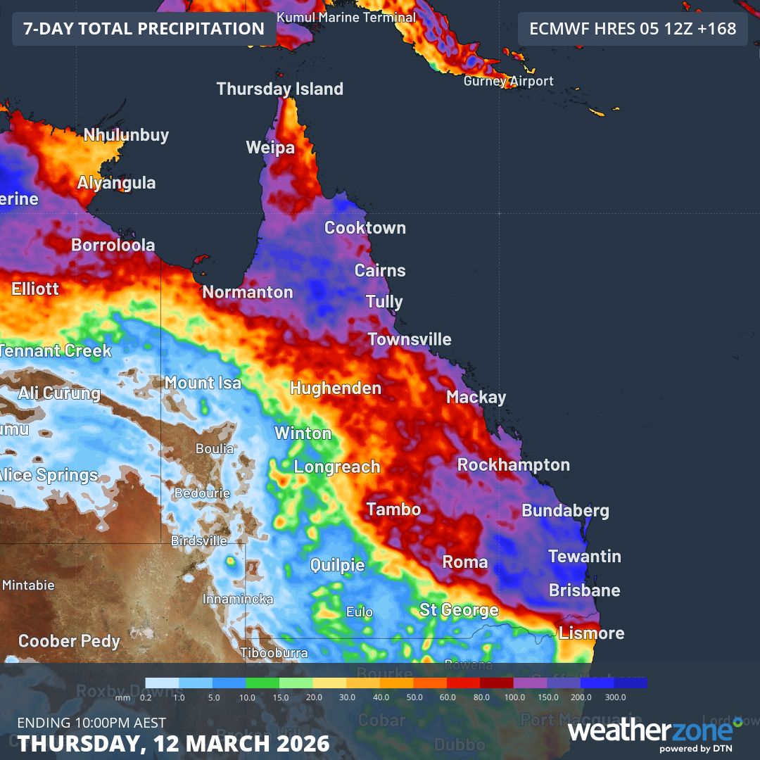
Image: Forecast accumulated rain during the seven days ending at 10pm AEST on Thursday, March 12, 2026, according to the ECMWF model. Weatherzone.
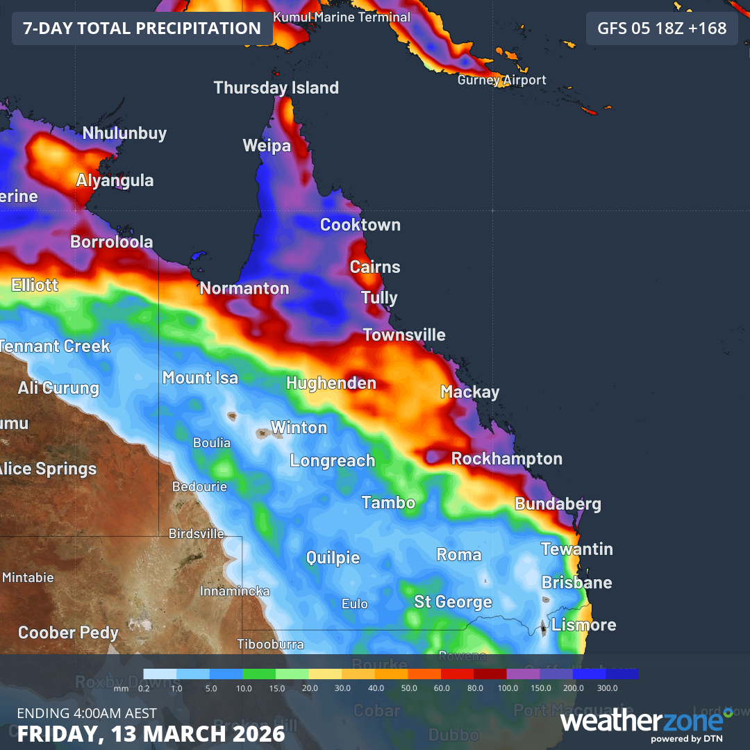
Image: Forecast accumulated rain during the seven days ending at 4am AEST on Friday, March 13, 2026, according to the GFS model. Source: Weatherzone.
The forecast uncertainty for southeast Qld this weekend and early next week will mean daily rainfall predictions will feature large ranges and may jump around in the coming days.
For example, The Bureau of Meteorology’s current rainfall forecast for Brisbane has a range of 15 to 70 mm on Sunday and 10 to 60 mm on Monday. The lower number in these ranges is what is most likely to fall (a 75% chance of at least that amount) each day, while the second number in the range only has a low chance of occurring (25% chance of at least that amount).
Be sure to stay up to date with the latest forecasts and warnings over the coming days if you live in northern, central or eastern Qld.