
Queensland deluge causes major flooding, relief in sight
Intense rain caused flooding in parts of central and southeast Queensland on Monday, but drier weather will return to much of the sodden state from Tuesday.
Abundant atmospheric moisture interacting with a low pressure system and associated trough caused heavy rain to inundate parts of central Qld on Monday.
Colossal rain rates
Rainfall rates exceeded 240 mm in six hours and 180 mm in three hours during the day’s most violent downpours from slow-moving thunderstorms. Some of the standout observations from Monday included:
- Westwood Range: 244 mm in six hours (to 4:15pm), 181 mm in three hours (to 3:30pm) and 82 mm in one hour (to 1:30pm)
- Captain Creek: 217 mm in six hours (to 4:30pm)
- Eden: 146 mm in three hours (to 4:04pm) and 74 mm in one hour (to 2:45pm)
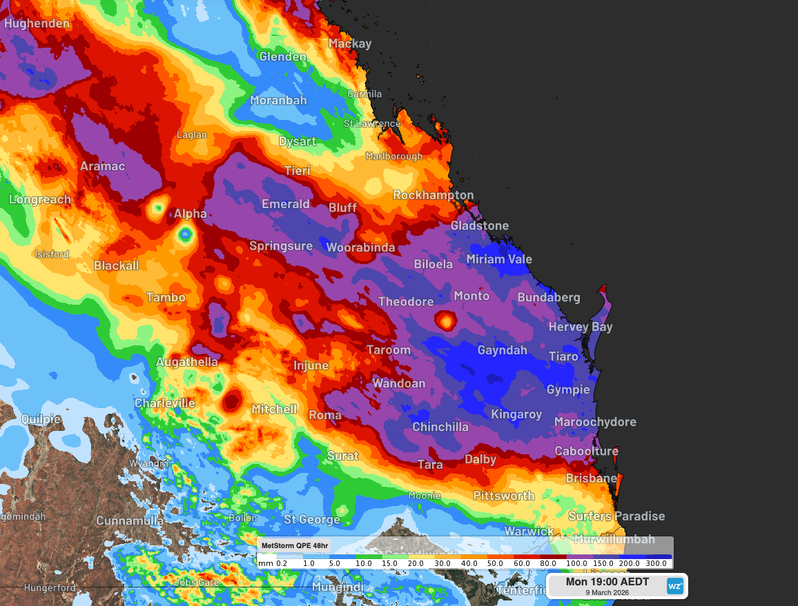
Image: Estimated rainfall during the 48 hours ending at 6pm AEST on Monday, March 9, 2026. Source: Weatherzone.
Rivers flooding rapidly
Monday’s rain caused flash flooding and contributed to major riverine flooding in parts of central and southeast Qld. These floodwaters cut off numerous roads as rivers rose rapidly in response to the intense falls.
The Kroombit Creek, which flows near Biloela, went from 0 metres at 2pm AEST on Monday to 13.3 metres by 6pm. This was well above the major flood height of 4.2 metres and the bridge height of 5.6 metres.
Water levels on Monday evening were also above the major flood level in the Burnett River at Paradise Dam and the Boyne River at Boondooma Dam. Water levels were rising at Wuruma Dam on Monday afternoon, with spills expected to commence on Monday night. Sunwater advised people downstream of the dam that outflows are expected to “increase significantly overnight. People downstream of Wuruma Dam must MONITOR CONDITIONS as they are changing.”
Monday’s heavy rain and flooding come at the tail end of several days of wet weather across Qld, brought on by a tropical low moving over the state from the Coral Sea and dragging a large mass of tropical moisture into a slow-moving low pressure trough.
On Monday afternoon, a flood watch was in place for most of the state due to the risk of widespread minor to moderate flooding and isolated major flooding.
Respite on the way
Fortunately, rain will ease over central and southeast Qld from Tuesday morning as the low pressure system and associated trough move off the coast and over the Coral Sea. However, rain and thunderstorms will continue to affect the state’s far north for the rest of the week.
The Queensland Government advises people in flood-affected areas to:
- Drive to raod conditions and remember if it’s flooded, forget it.
- Visit Qld Traffic to check road closures and traffic conditions before you travel.
- Keep up to date with the latest warnings.
- Visit the Get Ready Qld website for information on preparing your home and family for this severe weather event.