
Queensland bracing for severe tropical cyclone
A tropical cyclone is likely to hit northern Queensland later this week, with the Bureau of Meteorology predicting a category three severe tropical cyclone to make landfall in the state’s north.
Tropical low gaining strength
A tropical low is currently gaining strength over the northern Coral Sea. At 10am AEST, this low was located about 890 km to the east northeast of Willis Island, approximately 1,300 km off the Qld coast.
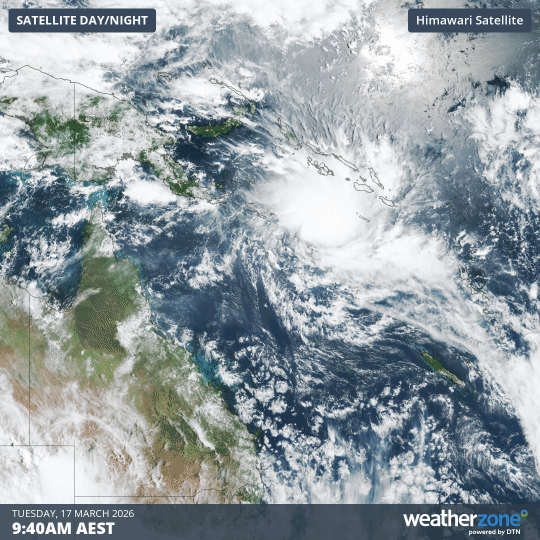
Image: Visible satellite image showing the tropical low spinning over the Coral Sea on Tuesday. March 17, 2026. Source: Weatherzone.
The low pressure system is expected to move towards the west over the next few days, likely gaining strength as it traverses the warm northern Coral Sea and heads towards Qld.
Landfall in Qld possible later this week
The Bureau of Meteorology expects the system to become a tropical cyclone by Wednesday and reach category three strength on Thursday or Friday. Based on the Bureau’s current forecast track, this system could approach the eastern side of the Cape York Peninsula as a category three severe tropical cyclone on Thursday or Friday.
Some forecast guidance even suggests this system could make landfall as a category four tropical cyclone.
If this system does make landfall as a severe tropical cyclone, it would be capable of causing:
- Destructive winds with sustained wind speeds possibly reaching 140 to 160 km/h
- Heavy rainfall causing flash flooding
- Large waves and abnormally high tides that could cause flooding in low-lying coastal areas
Northern Territory next in line
After crossing the Cape York Peninsula and briefly weakening later this week, computer models suggest the system could reintensify over the warm Gulf of Carpentaria and make a second landfall over the eastern Top End in the Northern Territory over the weekend.
It’s too early to know with much confidence where the system will move beyond the weekend. However, some models predict that it will weaken while tracking over the Top End and Kimberley early next week before passing to the north of Western Australia and regaining strength in the middle of next week. If this happens, it may also cause tropical cyclone impacts in parts of northern WA next week.
This system has the potential to cause severe weather in three states this week and next week, so anyone in northern Australia should pay close attention to the latest tropical cyclone advisories and track maps to stay up to date with the most accurate information.
If this system does become a tropical cyclone, it will be named Narelle.