
Prolonged Top End heatwave as Australia’s most reliable cloud appears
Two interesting meteorological phenomena are occurring this week in the Northern Territory’s Top End: an ongoing heatwave, and the seasonal appearance of "Hector the Convector" – a storm cloud that develops over the Tiwi Islands north of Darwin at roughly the same time every day for months on end.
The heatwave
While most southerners would consider the Top End hot year-round, and while October and November are on average the hottest months for maximum temperatures at many locations, the region will be even hotter than usual this week.
- From Wednesday onwards, Darwin is expected to reach 35°C or 36°C for at least the next six days. The October average maximum is 33.4°C.
- Away from the sea breeze in the NT’s third-largest population centre of Katherine, three hours southeast of Darwin, temperatures should nudge 40°C by the end of the week. The October average maximum is 37.6°C.
Minimum temperatures at the above locations will also be a degree above average or slightly higher in the week ahead, prompting the BoM to declare a low intensity heatwave at present – with the heatwave forecast rising to severe and even extreme at some locations by the end of the week.
This is based on the BoM’s definition of heatwaves as a period of three or more consecutive days during which maximum and minimum temperatures are "unusually hot".
Hector the Convector
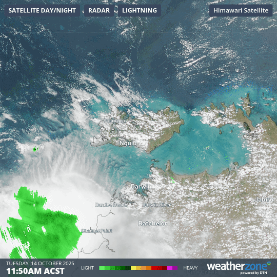
Image: "Hector the Convector" can be seen forming over the Tiwi Islands in this three-hour radar and satellite loop to 2:50pm (ACST).
Thunderstorm clouds form when warm, moisture-laden air rises into higher levels of the atmosphere, then cools as it gets higher. This causes water vapour to condense into liquid drops, producing cloud.
Hector the Convector ("convection" means the vertical rising of air) was named by pilots during World War II who used it for navigation when flying near the Top End, noting how reliable it was in its appearance.
When sea breezes flow over the Tiwi Islands from all directions and clash in the elevated interior of the islands, Hector forms as the converging breezes force air to rise, creating a column of warm and moist air that produces a towering cumulonimbus cloud.
Melville Island – the largest of the Tiwi Islands – cannot quite be seen from Darwin as it’s approximately 60 km north of the city. However, Hector can often be spotted above the island with its towering cumulus clouds, while air passengers flying in and out of Darwin Airport often get a good glimpse too.