
Powerful south-westerly ground swell impacts Tasmania
Very large, long period waves are making for treacherous conditions along the western and northern coastlines of Tasmania.
A series of cold fronts, which have brought gusty winds and cold conditions to much of the southeast, generated these large waves over the last week. Intense south to south-westerly winds over the Southern Ocean directed towards Australia with these fronts built this powerful swell event with passage of each frontal system across an already active sea state.
On Tasmania’s western coast, the Cape Sorell directional wave buoy captured some very large waves bringing dangerous surf. Significant and maximum wave height both rapidly increased over Saturday afternoon as the large groundswell filled in. By Saturday evening, the buoy recorded an initial peak in significant wave height around 9.2 meters, with a maximum wave height of about 17 meters! While swell this large is impressive in its own rights, the peak wave period associated with this peak was very long at just over 22 seconds. A combination of very long period and large swell height makes these waves particularly harmful and conductive to elevated levels of coastal erosion as each wave carries much more energy than lesser period swell waves.
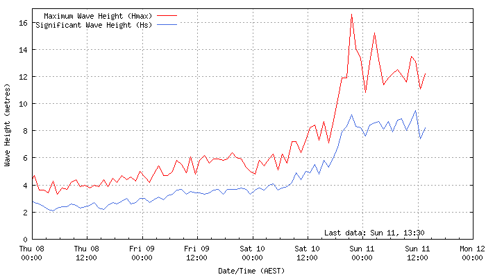
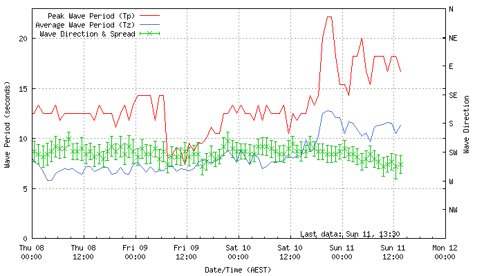
Swell observations, including Significant Wave Height, Maximum Wave Height, Peak Wave Period, Average Wave Period and Wave Direction, recorded at the Cape Sorell Directional Wave Buoy located about 10km offshore, west of Cape Sorell, western Tasmania. (bom.gov.au)
This sizeable swell is also impacting southeast South Australia, parts of Victoria and southern Tasmania. The Cape du Couedic wave observation buoy off Kangaroo Island in South Australia saw significant wave heights rise above 7 meters early this morning, with maximum wave heights above 10 meters recorded at times this morning.
This large swell reached a peak last night, and will gradually ease over the remainder of Sunday. However, this swell will likely remain very large well into the evening before easing more significantly on Monday and Tuesday.